Mapleton, Pennsylvania facts for kids
Quick facts for kids
Mapleton, Pennsylvania
|
|
|---|---|
|
Borough
|
|

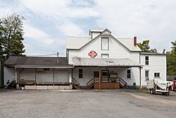
H.O. Andrews Feed Mill on Main Street
|
|

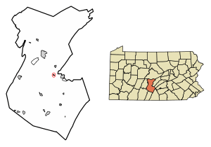
Location of Mapleton in Huntingdon County, Pennsylvania.
|
|
| Country | United States |
| State | Pennsylvania |
| County | Huntingdon |
| Government | |
| • Type | Borough Council |
| Area | |
| • Total | 0.19 sq mi (0.50 km2) |
| • Land | 0.18 sq mi (0.47 km2) |
| • Water | 0.01 sq mi (0.02 km2) |
| Elevation | 594 ft (181 m) |
| Population
(2020)
|
|
| • Total | 418 |
| • Density | 2,284.15/sq mi (882.32/km2) |
| Time zone | UTC-5 (Eastern (EST)) |
| • Summer (DST) | UTC-4 (EDT) |
| Zip code |
17052
|
| Area code(s) | 814 |
| FIPS code | 42-47248 |
| GNIS feature ID | 1215271 |
| Website | http://www.mapleton-pa.com/index.htm |
| Local phone exchanges: 542, 543 | |
Mapleton is a small town, called a borough, in Huntingdon County, Pennsylvania. It's located in the United States. In 2020, about 418 people lived there. Mapleton sits right on the Juniata River, which is a smaller river that flows into the larger Susquehanna River.
History of Mapleton
Mapleton started as a community when the Pennsylvania Railroad decided to extend its tracks to this spot. The town got its name from a group of maple trees that grew nearby where the first buildings were put up.
A special building in Mapleton, the H.O. Andrews Feed Mill, is quite old and important. It was added to the National Register of Historic Places in 1990. This means it's recognized for its historical value.
Mapleton's Geography
Mapleton is located in the eastern part of Huntingdon County. It's on the south side of the Juniata River. The town is right at the western entrance of a "water gap" through Jacks Mountain. A water gap is a place where a river cuts through a mountain ridge.
Pennsylvania Route 655 goes through the middle of Mapleton. This road can take you south about 14 miles to Saltillo. If you go north for about 2 miles, you'll reach U.S. Route 22. From US 22, you can travel east 4 miles to Mount Union or northwest 8 miles to Huntingdon. Huntingdon is the main town, or county seat, for the county.
The United States Census Bureau says that Mapleton covers a total area of about 0.5 square kilometers. A small part of this area, about 0.02 square kilometers, is water.
Mapleton's Population
| Historical population | |||
|---|---|---|---|
| Census | Pop. | %± | |
| 1870 | 389 | — | |
| 1880 | 444 | 14.1% | |
| 1890 | 715 | 61.0% | |
| 1900 | 612 | −14.4% | |
| 1910 | 752 | 22.9% | |
| 1920 | 802 | 6.6% | |
| 1930 | 894 | 11.5% | |
| 1940 | 803 | −10.2% | |
| 1950 | 742 | −7.6% | |
| 1960 | 666 | −10.2% | |
| 1970 | 661 | −0.8% | |
| 1980 | 591 | −10.6% | |
| 1990 | 529 | −10.5% | |
| 2000 | 470 | −11.2% | |
| 2010 | 439 | −6.6% | |
| 2020 | 418 | −4.8% | |
| Sources: | |||
The population of Mapleton has changed over the years. In 2000, there were 473 people living in the borough. These people lived in 191 households, and 135 of these were families.
About 28% of the households in 2000 had children under 18 living with them. Most households, about 58%, were married couples living together. About 22% of all households were made up of people living alone. Around 12% of those living alone were 65 years old or older. On average, there were about 2.48 people in each household.
The people in Mapleton are of different ages. In 2000, about 22% of the population was under 18 years old. About 16.7% of the people were 65 years old or older. The average age in Mapleton was 41 years.
See also
 In Spanish: Mapleton (Pensilvania) para niños
 | Janet Taylor Pickett |
 | Synthia Saint James |
 | Howardena Pindell |
 | Faith Ringgold |


