
Huntingdon, Pennsylvania facts for kids
Quick facts for kids
Huntingdon, Pennsylvania
Standing Stone Village (historical)
|
|||
|---|---|---|---|
|
Borough
|
|||

Presbyterian Church
|
|||
|
|||
| Nickname(s):
Ye Ancient Borough (historical)
|
|||
| Motto(s):
"Our Home, Our Town"
|
|||

Location of Huntingdon in Huntingdon County, Pennsylvania
|
|||

Huntingdon, Pennsylvania
Location in Pennsylvania

Huntingdon, Pennsylvania
Location in the United States
|
|||
| Country | United States | ||
| State | Pennsylvania | ||
| County | Huntingdon | ||
| Plat drawn of streets and lots | 1767 | ||
| Incorporated | 1796 | ||
| Government | |||
| • Type | Borough Council | ||
| Area | |||
| • Total | 3.70 sq mi (9.59 km2) | ||
| • Land | 3.62 sq mi (9.37 km2) | ||
| • Water | 0.08 sq mi (0.22 km2) | ||
| Elevation | 751 ft (229 m) | ||
| Population
(2020)
|
|||
| • Total | 6,827 | ||
| • Density | 1,887.48/sq mi (728.70/km2) | ||
| Time zone | UTC-5 (Eastern (EST)) | ||
| • Summer (DST) | UTC-4 (EDT) | ||
| ZIP Codes |
16652, 16654
|
||
| Area code(s) | 814 | ||
| FIPS code | 42-36368 | ||
| GNIS feature ID | 1215270 | ||


Huntingdon is a borough (a type of town) in Pennsylvania, USA. It is the main town and county seat of Huntingdon County, Pennsylvania. The town is located along the Juniata River, about 32 miles (51 km) east of Altoona and 92 miles (148 km) west of Harrisburg, the state capital.
In 2020, Huntingdon had a population of 6,827 people. It is the largest town near Raystown Lake, a large reservoir that helps control floods.
Huntingdon is on the main railway line used by Norfolk Southern freight trains. This area is known for farming and outdoor activities. It has many forests and natural resources like coal and limestone. In the past, many iron factories operated here. Today, Dairy farms are very important to the local economy.
The town is also a stop for Amtrak passenger trains, connecting Pittsburgh to Philadelphia and New York City. Huntingdon is home to Juniata College, a university founded in 1876.
Contents
History
Early Inhabitants and Founding
The first people to live in the Huntingdon area were the Susquehannock tribe. Sadly, due to wars with other tribes, diseases brought by Europeans, and violence from settlers, the Susquehannock people are no longer a distinct group.
In 1768, a man named Rev. William Smith started selling land lots in the area. He is known as the founder of Huntingdon. The town was built on old corn fields near where Standing Stone Creek flows into the Juniata River.
A tall stone monument stands on Third Street. It was built to celebrate the town's 100th anniversary. This monument looks like an old stone shaft that existed before 1750. Its original purpose is not fully clear, but it might have been a trail marker. Some natural rock formations nearby, called Pulpit Rocks, also stand upright.
The town was named Huntingdon, likely after a town in England, following a common trend for naming Pennsylvania settlements like Bedford and Carlisle. In 1796, Huntingdon officially became a borough.
Industrial Growth and Flooding
Huntingdon was an important meeting point for two railroads: the Huntingdon and Broad Top Mountain Railroad and the Pennsylvania Railroad. It was also a key port on the Pennsylvania Canal, which was a system of waterways for transportation.
Over the years, Huntingdon was home to many factories. They made things like flour, heavy machines, furniture, and shoes. In the 1800s, J. C. Blair became famous for making and selling writing tablets across the country. His factory was first in downtown Huntingdon, then moved to nearby Alexandria.
The Herncane Broom Factory started in 1863. It made many brooms, even supplying the Pennsylvania Railroad Company. The factory employed 14 workers and 3 traveling salespeople. It was destroyed by fire in 1903.
The Huntingdon area has experienced several major floods, including in 1889, 1936, and 1972. More recently, in 2004, Hurricane Ivan caused significant flooding near the town.
The Huntingdon Borough Historic District was recognized as an important historical place in 1986. In June 2017, Huntingdon celebrated its 250th anniversary with special events.
Geography
Location and Area
Huntingdon is located in the northern part of Huntingdon County. It sits on the northeast side of the Juniata River, which flows east into the Susquehanna River.
 |
Tyrone | State College | Lewistown | |
| Altoona | McVeytown | |||
| Johnstown | Hollidaysburg | Harrisburg |
The borough covers a total area of about 3.7 square miles (9.6 square kilometers). Most of this area is land, with a small part being water, mainly from the river.
Neighboring Towns
Huntingdon borders these other towns and townships in Huntingdon County:
- Smithfield Township to the south and west, across the Juniata River.
- Henderson Township to the east.
- Oneida Township to the north and east.
Climate
Huntingdon has a humid continental climate. This means it has warm summers and winters that are moderately cold.
| Climate data for Huntingdon, Pennsylvania | |||||||||||||
|---|---|---|---|---|---|---|---|---|---|---|---|---|---|
| Month | Jan | Feb | Mar | Apr | May | Jun | Jul | Aug | Sep | Oct | Nov | Dec | Year |
| Record high °F (°C) | 79 (26) |
77 (25) |
85 (29) |
95 (35) |
98 (37) |
100 (38) |
105 (41) |
105 (41) |
102 (39) |
97 (36) |
79 (26) |
73 (23) |
105 (41) |
| Mean daily maximum °F (°C) | 38 (3) |
39 (4) |
50 (10) |
62 (17) |
74 (23) |
82 (28) |
85 (29) |
83 (28) |
78 (26) |
66 (19) |
52 (11) |
40 (4) |
62 (17) |
| Mean daily minimum °F (°C) | 19 (−7) |
19 (−7) |
27 (−3) |
36 (2) |
46 (8) |
55 (13) |
59 (15) |
58 (14) |
51 (11) |
39 (4) |
31 (−1) |
22 (−6) |
39 (4) |
| Record low °F (°C) | −29 (−34) |
−23 (−31) |
−10 (−23) |
6 (−14) |
21 (−6) |
29 (−2) |
42 (6) |
36 (2) |
24 (−4) |
13 (−11) |
−10 (−23) |
−22 (−30) |
−29 (−34) |
| Average precipitation inches (mm) | 2.8 (71) |
2.5 (64) |
3.5 (89) |
3.3 (84) |
3.8 (97) |
3.9 (99) |
3.9 (99) |
3.7 (94) |
3.0 (76) |
2.8 (71) |
2.6 (66) |
2.7 (69) |
38.5 (979) |
| Source: Weatherbase | |||||||||||||
Demographics
Population Overview
As of the 2010 census, Huntingdon had 7,093 people living in 2,674 households. About 1,461 of these were families. The population density was about 2,027 people per square mile (782 people per square kilometer).
| Historical population | ||
|---|---|---|
| Year | Pop. | ±% p.a. |
| 1800 | 688 | — |
| 1810 | 676 | −0.18% |
| 1820 | 848 | +2.29% |
| 1840 | 1,145 | +1.51% |
| 1850 | 1,470 | +2.53% |
| 1860 | 1,890 | +2.54% |
| 1870 | 3,634 | +6.76% |
| 1880 | 4,125 | +1.28% |
| 1890 | 5,729 | +3.34% |
| 1900 | 6,053 | +0.55% |
| 1910 | 6,861 | +1.26% |
| 1920 | 7,051 | +0.27% |
| 1930 | 7,558 | +0.70% |
| 1940 | 7,170 | −0.53% |
| 1950 | 7,330 | +0.22% |
| 1960 | 7,234 | −0.13% |
| 1970 | 6,987 | −0.35% |
| 1980 | 7,042 | +0.08% |
| 1990 | 6,843 | −0.29% |
| 2000 | 6,918 | +0.11% |
| 2010 | 7,093 | +0.25% |
| 2020 | 6,827 | −0.38% |
| Sources: Source: |
||
Most residents (94.61%) were White. Other groups included African American (1.93%), Asian (1.51%), and people of two or more races (1.56%). About 1.49% of the population was Hispanic or Latino.
Age and Income
The population was spread out in terms of age. About 17.7% were under 18 years old, and 24.4% were between 18 and 24. The median age was 33 years.
The median income for a household in Huntingdon was $35,057. For families, the median income was $54,621. About 15.3% of the population lived below the poverty line.
Recreation
Huntingdon offers many outdoor and recreational activities. Nearby, in Smithfield Township, are the offices for the Pennsylvania Game Commission and the Bureau of Forestry. State Game Lands 322 is also close by, offering natural areas to explore.
The town has several public parks:
- George N. Weaver Memorial Park, with a ball field and playground.
- Portstown Park, located along the Juniata River.
- Blair Field, next to Standing Stone Creek.
Historic Blair Park is managed by a non-profit group. It features a gazebo and a flat trail for hiking and biking. A small chapel in the park is used by a local church.
Huntingdon is also the closest town to the Allegrippis Trail system. This system is ranked among the best mountain bike trails in the world!
Rankings
Huntingdon has received some special recognitions:
- In 2009, Budget Travel magazine readers voted Huntingdon the 5th Coolest Small Town in the United States.
- In 2015, Niche.com chose Huntingdon as the 7th Best City to Retire in Pennsylvania.
Education
Higher Education
- Juniata College (1700 Moore Street)
Public Schools
- Huntingdon Area Senior High School - for Grades 9-12 (2400 Cassady Avenue)
- Huntingdon Area Middle School - for Grades 6-8 (2500 Cassady Avenue)
- Southside Elementary School - for Grades K-5 (10906 Station Road)
- Standing Stone Elementary School - for Grades K-5 (10 West 29th Street)
Private Schools
- Calvary Christian Academy - for Grades K-12 (300 Standing Stone Avenue)
Public Services
Emergency Services
- Huntingdon Borough Police Department (530 Washington Street)
- Huntingdon Ambulance Services (530 Washington Street)
- Huntingdon County Sheriff's Office (241 Mifflin Street)
Postal Services
- Huntingdon Post Office (401 Washington Street)
- Huntingdon Post Office at Juniata College (1700 Moore Street)
Public Library
- Huntingdon County Library (330 Penn Street)
Transportation
- Huntingdon station (Amtrak) (Fourth & Allegheny streets) - for passenger train service.
Water Source
The drinking water for Huntingdon and Smithfield Township comes from Standing Stone Creek. The water treatment plant is located in the east end of the borough.
Media
Newspapers
- The Daily News
- The Valley Log
Radio
Huntingdon has its own radio stations: WHUN WOWY 103.5 FM and Bigfoot Country 106.3 FM. You can also hear broadcasts from nearby cities:
Television
Huntingdon receives all its television channels from the Johnstown-Altoona-State College media market.
Annual Events
Huntingdon hosts several fun events throughout the year:
- Mayfest - A historical festival held on the last Saturday of April in downtown Huntingdon.
- Memorial Day Parade - Held annually on the last Monday of May.
- Hauntingdon – A series of events leading up to Halloween, including a parade and trick-or-treating.
- Veterans Day Parade - Held in November to honor veterans.
- Tree Lighting Ceremony - Held in the first week of December on Washington Street.
- Christmas Parade - Held on a Saturday night in December.
- Cultural District Walking Tours – Free tours led by volunteers during the summer months.
Non-profit Organizations
Many non-profit groups help the community in Huntingdon:
- Rotary Club of Huntingdon (10305 Raystown Road)
- Kiwanis Club of Huntingdon (2506 Shadyside Avenue)
- Stone Creek Valley Lions Club (5303 Cold Springs Road)
- The Salvation Army (2514 Shadyside Avenue)
- Huntingdon Food Pantry (5th & Mifflin streets)
- Huntingdon House Domestic Violence Shelter (401 7th Street)
- Huntingdon County Humane Society (11371 School House Hollow Road)
Notable People
Many interesting people have connections to Huntingdon:
- Adaline Hohf Beery (1859–1929), author and newspaper editor.
- Stan Belinda, a professional baseball pitcher.
- Jackson Berkey, a composer, pianist, and singer known for his work with Mannheim Steamroller.
- Hugh Brady, a military commander.
- Christina Crosby, author and professor.
- Joseph Dysart, an Iowa farmer and politician.
- Jean Geissinger, a professional baseball player.
- Chuck Knox, a football coach for NFL teams.
- Dylan Lane, a game show host.
- Michael Norell screenwriter, actor, and executive producer.
- Horace Porter, a Civil War general and US diplomat.
- Chris Raschka, a children's book artist and author.
- Joseph Saxton (1799–1873), an inventor, watchmaker, and machinist.
- Richard Murray Simpson, a U.S. congressman.
- William Rudolph Smith (1787–1868), a Pennsylvania State Representative and Senator.
- Robert Elliott Speer, a religious leader.
- William Andrew Wallace (1827–1892), a state and U.S. Senator.
- George Benjamin Wittick, a photographer (1845–1903).
- Curtis Wright, a country songwriter and former member of the band Shenandoah.
- Samuel Zimmerman, a businessman who founded Niagara Falls, Ontario.
Images for kids
-
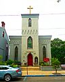
St. Johns Episcopal Church
-
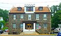
Huntingdon County Sheriff's Office
-
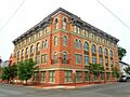
Mutual Benefit Building at 4th and Washington streets
-
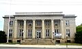
Post office


See also
 In Spanish: Huntingdon (Pensilvania) para niños
