Fulton County, Pennsylvania facts for kids
Quick facts for kids
Fulton County
|
||
|---|---|---|
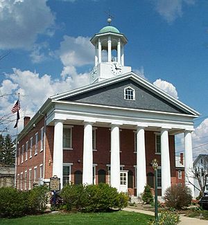
The Fulton County Courthouse
|
||
|
||
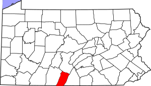
Location within the U.S. state of Pennsylvania
|
||
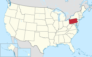 Pennsylvania's location within the U.S. |
||
| Country | ||
| State | ||
| Founded | April 19, 1850 | |
| Named for | Robert Fulton | |
| Seat | McConnellsburg | |
| Largest borough | McConnellsburg | |
| Area | ||
| • Total | 438 sq mi (1,130 km2) | |
| • Land | 438 sq mi (1,130 km2) | |
| • Water | 0.5 sq mi (1 km2) 0.1% | |
| Population
(2020)
|
||
| • Total | 14,556 | |
| • Density | 33/sq mi (13/km2) | |
| Time zone | UTC−5 (Eastern) | |
| • Summer (DST) | UTC−4 (EDT) | |
| Congressional district | 13th | |
Fulton County is a place in Pennsylvania, a state in the United States. In 2020, about 14,556 people lived there. This makes it one of the less crowded counties in Pennsylvania.
The main town and county seat is McConnellsburg. Fulton County was started on April 19, 1850. It was made from a part of Bedford County. The county is named after a famous inventor, Robert Fulton. It is located in the southwest part of Pennsylvania.
Contents
What is Fulton County Like?
Fulton County covers about 438 square miles. Most of this area is land, with only a small amount of water. The county's water flows into the Chesapeake Bay. Most of it goes into the Potomac River. Some northern parts drain into the Juniata River, which then flows into the Susquehanna River.
The county has a climate with warm summers and cold winters. Temperatures in McConnellsburg usually range from about 29°F in January to 73°F in July.
Nearby Counties
Fulton County shares its borders with several other counties:
- Huntingdon County (to the north)
- Franklin County (to the east)
- Washington County, Maryland (to the south)
- Allegany County, Maryland (to the southwest)
- Bedford County (to the west)
How Was Fulton County Formed?
Fulton County is in a region called the Ridge-and-Valley Appalachians. This area has many folded and faulted rocks. These rocks were formed a very long time ago.
The mountains in Fulton County include Rays Hill, Town Hill, Sideling Hill, Scrub Ridge, and Meadow Grounds Mountain. These mountains are made of strong rocks like quartz sandstone. Broad Top, in the northeast, is a flat area with younger rocks.
Fulton County was never covered by glaciers during the Ice Age. However, the weather was very cold. Most of the county was likely a tundra during that time.
There is a Coal Field in the northwest part of the county. It has bituminous coal. Some old mines are there, but they don't cause many environmental problems today.
Who Lives in Fulton County?
| Historical population | |||
|---|---|---|---|
| Census | Pop. | %± | |
| 1850 | 7,567 | — | |
| 1860 | 9,131 | 20.7% | |
| 1870 | 9,360 | 2.5% | |
| 1880 | 10,149 | 8.4% | |
| 1890 | 10,137 | −0.1% | |
| 1900 | 9,924 | −2.1% | |
| 1910 | 9,703 | −2.2% | |
| 1920 | 9,617 | −0.9% | |
| 1930 | 9,231 | −4.0% | |
| 1940 | 10,673 | 15.6% | |
| 1950 | 10,387 | −2.7% | |
| 1960 | 10,597 | 2.0% | |
| 1970 | 10,776 | 1.7% | |
| 1980 | 12,842 | 19.2% | |
| 1990 | 13,837 | 7.7% | |
| 2000 | 14,261 | 3.1% | |
| 2010 | 14,845 | 4.1% | |
| 2020 | 14,556 | −1.9% | |
In 2000, about 14,261 people lived in Fulton County. There were about 5,660 households. The population density was about 33 people per square mile. Most people living here were White (98.25%).
About 31.7% of households had children under 18. Many families (59.5%) were married couples living together. The average household had 2.5 people.
The population was spread out by age. About 24.6% were under 18. About 14.5% were 65 or older. The average age was 38 years. For every 100 females, there were about 100 males.
Most people in Fulton County speak English. They often have a specific way of speaking called the Central Pennsylvania accent.
Population in 2020
| Race | Num. | Perc. |
|---|---|---|
| White (NH) | 13,726 | 94.3% |
| Black or African American (NH) | 124 | 0.85% |
| Native American (NH) | 25 | 0.17% |
| Asian (NH) | 41 | 0.3% |
| Pacific Islander (NH) | 3 | 0.02% |
| Other/Mixed (NH) | 491 | 3.4% |
| Hispanic or Latino | 146 | 1% |
The 2020 census showed that 94.3% of the population was White. About 0.85% were Black or African American. About 1% of the population was Hispanic or Latino.
Schools in Fulton County
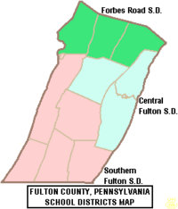
There are three school districts in Fulton County. They serve students from kindergarten to 12th grade:
- Central Fulton School District
- Forbes Road School District
- Southern Fulton School District
How Do People Travel in Fulton County?
Main Roads
Several important highways pass through Fulton County:
 PA 16: This road is called the Buchanan Trail. It starts in McConnellsburg and goes across South-Central Pennsylvania.
 US 30: This is part of the famous Lincoln Highway. It travels across the county. There is a short bypass around McConnellsburg.
 I-70: This interstate highway goes south through the western part of the county. It connects to another interstate in Maryland.
 I-76 / Penna Turnpike: This is part of the Pennsylvania Turnpike, a toll road. It crosses the northern part of the county. There is one exit and a travel center.
 US 522: This road comes from Maryland. It goes through McConnellsburg and is a main north-south road. It passes the county's only shopping center.
Other Transportation
Fulton County is one of only two counties in Pennsylvania that do not have any active railroad lines. The other county is Sullivan County.
Towns and Communities
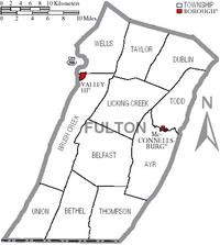
Pennsylvania has different types of towns. In Fulton County, there are boroughs and townships.
Boroughs
- McConnellsburg (This is the county seat)
- Valley-Hi
Townships
- Ayr Township
- Belfast Township
- Bethel Township
- Brush Creek Township
- Dublin Township
- Licking Creek Township
- Taylor Township
- Thompson Township
- Todd Township
- Union Township
- Wells Township
Other Communities
These are smaller places that are not officially boroughs or townships:
- Amaranth
- Big Cove Tannery
- Burnt Cabins
- Crystal Spring
- Dott
- Fort Littleton
- Harrisonville
- Hustontown
- Warfordsburg
- Waterfall
- Wells Tannery
- Wood
Population Ranking of Communities
This table shows the population of some communities based on the 2010 census.
† county seat
| Rank | City/Town/etc. | Municipal type | Population (2010 Census) |
|---|---|---|---|
| 1 | Belfast | Township | 1,448 |
| 2 | † McConnellsburg | Borough | 1,220 |
| 3 | Needmore | CDP | 170 |
| 4 | Valley-Hi | Borough | 15 |
Census-Designated Places
A census-designated place (CDP) is a special area defined by the U.S. Census Bureau. It's like a town but not officially incorporated.
See also
 In Spanish: Condado de Fulton (Pensilvania) para niños
 | William L. Dawson |
 | W. E. B. Du Bois |
 | Harry Belafonte |


