
Sideling Hill facts for kids
Quick facts for kids Sideling Hill |
|
|---|---|
_from_the_Victor_Cushwa_Memorial_Bridge_as_it_passes_through_the_Sideling_Hill_Road_Cut_in_Forest_Park,_Washington_County,_Maryland.jpg)
Interstate 68 road cut in Sideling Hill in western Maryland
|
|
| Highest point | |
| Elevation | 2,311 ft (704 m) |
| Prominence | 280 |
| Geography | |
| Location | West Virginia, Maryland, and Pennsylvania, U.S. |
| Parent range | Ridge-and-Valley province, Appalachian Mountains |
| Topo map | USGS Wells Tannery |
Sideling Hill is a long, narrow mountain ridge found in the Appalachian Mountains in the U.S.. It stretches across parts of Maryland, West Virginia, and Pennsylvania. The highest point on this ridge is called Fisher Point, which is about 2,310 feet (700 m) tall and located in Fulton County, Pennsylvania.
Contents
What is Sideling Hill?
Sideling Hill is a special type of mountain called a syncline mountain. Imagine a giant U-shape in the layers of rock. That's what a syncline is! This mountain formed when rock layers folded downwards.
The very top of the ridge is made of strong, hard rocks. These rocks are called conglomerate and sandstone. They are very tough and don't wear away easily. This hard rock cap helps the mountain keep its shape.
The sides of Sideling Hill are made of softer rocks. These softer rocks wear away much more easily. This is why you see long, narrow valleys running alongside the ridge.
What Animals and Plants Live Here?
Most of the top of Sideling Hill is covered in forests. These forests are full of deciduous trees. Deciduous trees are trees that lose their leaves in the fall. You'll find many types of oak and hickory trees here. Sometimes, you might also see evergreen pine trees. Evergreen trees keep their needles all year round.
How People Cross Sideling Hill
Sideling Hill is a steep mountain. Because of this, only a few major roads, railroads, and canals have been built to cross it. These crossings are amazing examples of engineering!
East Broad Top Railroad Tunnel

The East Broad Top Railroad built a tunnel through Sideling Hill. This happened between 1873 and 1874. The tunnel was part of their main railway line.
This tunnel is single-tracked, meaning only one train could go through at a time. It also has curves at both ends. In the past, the tunnel had special doors. These doors stopped strong winds from blowing through. The wind could cause water inside the tunnel to freeze on the tracks. This ice could make trains derail, or go off the tracks.
The railroad used this tunnel from 1874 until 1956. The tracks are still inside, but trains don't use it anymore. The tunnel and railway line are private property. They are not open for visitors.
Pennsylvania Turnpike (I-76)
The Pennsylvania Turnpike (Interstate 76) crosses Sideling Hill. It goes around two older tunnels that the Turnpike used to use. These tunnels were called the Sideling Hill Tunnel and the Rays Hill Tunnel.
The new bypass opened in 1968. It cost a lot of money to build. The old road through the tunnels is now known as the Abandoned Pennsylvania Turnpike.
Sideling Hill Tunnel (Pennsylvania)

The Sideling Hill Tunnel has an interesting history. It was first started in the 1880s by the South Pennsylvania Railroad. But the railroad project stopped, and the tunnel was left unfinished.
Later, in the 1930s, the Pennsylvania Turnpike Commission decided to use the old railroad path. They finished building the tunnel for highway use. It opened in 1940. This tunnel was the longest of the original seven turnpike tunnels.
By 1968, there was too much traffic on the Turnpike. So, new, wider highways were built to go around the tunnels. The Sideling Hill Tunnel was no longer used for cars. For many years, it was used to test new highway technologies.
In 2001, the tunnel was sold for just $1! Now, a group called the Southern Alleghenies Conservancy takes care of it. They have turned it into a bike trail for people to enjoy.
Sideling Hill Road Cut (I-68 and U.S. 40, Maryland)


The Sideling Hill Road Cut is a huge notch carved into the mountain. It's on Interstate 68 and U.S. Route 40 in Maryland. This cut is about 340-foot (100 m) deep. That's like digging a hole as deep as a 30-story building!
It's an amazing sight to see how people cut through the mountain. It's also one of the best places in the northeastern United States to see rock layers. You can see almost 810 feet (250 m) of rock layers here. These layers are tightly folded into a U-shape, just like the mountain itself.
Rest Stop and Visitor Center
There's a rest stop near the Sideling Hill Road Cut. It has a special bridge for people to walk across Interstate 68. From this bridge, you can get great views of the huge road cut.
The rest stop used to have a museum called the Sideling Hill Exhibit Center. It opened in 1991 and taught visitors about geology. It closed in 2009 to save money. Many of the exhibits from the museum are now at the Hancock Museum nearby. In 2015, the building reopened as a Welcome Center.
National Road (U.S. 40 Scenic)
Before Interstate 68 was built, the old National Road (now U.S. Route 40 Scenic) crossed Sideling Hill. This road had very steep hills on both sides. It also had a sharp, winding turn at the top of the mountain.
Potomac River Water Gap
The Potomac River flows through Sideling Hill. It has carved a "water gap" through the ridge. This gap provides a low-level path for transportation. The CSX Railroad uses it on the West Virginia side of the river. On the Maryland side, you'll find the old Chesapeake and Ohio Canal. This canal is now a national historical park. There's also a former railroad line, now a rail trail, for walking and biking.
Images for kids
-
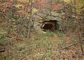
East Broad Top Railroad Tunnel at Sideling Hill, south portal
-
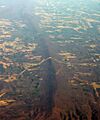
Air photo of Sideling Hill, showing the Interstate 68 roadcut and the path of the National Road.

