
West Virginia facts for kids
Quick facts for kids
West Virginia
|
|||
|---|---|---|---|
|
|||
| Nickname(s):
Mountain State
|
|||
| Motto(s): | |||
| Anthem: Four songs | |||

Location of West Virginia within the United States
|
|||
| Country | United States | ||
| Before statehood | Part of Virginia | ||
| Admitted to the Union | June 20, 1863 (35th) | ||
| Capital (and largest city) |
Charleston | ||
| Largest county or equivalent | Kanawha | ||
| Largest metro and urban areas | Charleston–Huntington (combined) Huntington (metro and urban) |
||
| Legislature | West Virginia Legislature | ||
| • Upper house | Senate | ||
| • Lower house | House of Delegates | ||
| Judiciary | Supreme Court of Appeals of West Virginia | ||
| U.S. senators | Shelley Moore Capito (R) Jim Justice (R) |
||
| U.S. House delegation | 1: Carol Miller (R) 2: Riley Moore (R) (list) |
||
| Area | |||
| • Total | 24,230 sq mi (62,755 km2) | ||
| • Land | 24,078 sq mi (62,361 km2) | ||
| • Water | 152 sq mi (394 km2) 0.6% | ||
| Area rank | 41st | ||
| Dimensions | |||
| • Length | 240 mi (385 km) | ||
| • Width | 130 mi (210 km) | ||
| Elevation | 1,513 ft (461 m) | ||
| Highest elevation | 4,863 ft (1,482 m) | ||
| Lowest elevation
(Potomac River at Virginia border)
|
240 ft (73 m) | ||
| Population
(2025)
|
|||
| • Total | |||
| • Rank | 39th | ||
| • Density | 77/sq mi (29.8/km2) | ||
| • Density rank | 29th | ||
| • Median household income | |||
| • Income rank | 49th | ||
| Demonym(s) | West Virginian, Mountaineer | ||
| Language | |||
| • Official language | De jure: English | ||
| Time zone | UTC−05:00 (Eastern) | ||
| • Summer (DST) | UTC−04:00 (EDT) | ||
| USPS abbreviation |
WV
|
||
| ISO 3166 code | US-WV | ||
| Traditional abbreviation | W.Va. and W.V. | ||
| Latitude | 37°12′ N to 40°39′ N | ||
| Longitude | 77°43′ W to 82°39′ W | ||


.png)
West Virginia is a state in the United States. It is located in the Southern and Mid-Atlantic parts of the country. West Virginia is surrounded by land, meaning it has no coastlines. It shares borders with Pennsylvania, Maryland, Virginia, Kentucky, and Ohio.
West Virginia is the 10th smallest state by land area. It is also the 12th least populated state. About 1.79 million people live there. The capital and largest city is Charleston.
West Virginia became a state on June 20, 1863, during the American Civil War. It was special because it was the only state to break away from a Confederate state (Virginia) to join the Union. Most people in western Virginia were farmers who did not own slaves. They wanted to stay with the Union. The state later made slavery illegal.
The state is famous for its mountains and rolling hills. It has a long history with coal mining and logging. West Virginia is also a great place for outdoor activities. You can go skiing, whitewater rafting, fishing, hiking, mountain biking, and rock climbing there.
Contents
West Virginia's History
West Virginia has a rich history, from ancient times to its founding as a state. Its mountains and rivers have always played a big role in how people lived.
Ancient Times and Native Americans
Long ago, different groups of Native Americans lived in this area. They built large earthen mounds, which you can still see today in places like Moundsville. These mounds show that early people had organized societies and traded goods.
Around the 1670s, the powerful Iroquois tribes from New York used the Ohio Valley as a hunting ground. They pushed out other tribes. Later, different Native American groups settled in West Virginia.
European Exploration and Early Settlements
European explorers started coming to West Virginia in the late 1600s. In 1671, a group led by Thomas Batts and Robert Fallam explored the area. They were the first Europeans to see Kanawha Falls.
In the 1700s, German settlers from Pennsylvania founded New Mecklenburg, which is now Shepherdstown. George Washington also surveyed parts of the land between 1748 and 1751. He noted that many German families were already living there.
During the French and Indian War, Native American allies of the French attacked the small British settlements. Later, during the American Revolutionary War, settlers in western Virginia supported the American cause.
Becoming a Separate State
The people in western Virginia were often unhappy with the government in eastern Virginia. The eastern part of Virginia had more power and was focused on large farms that used enslaved people. Western Virginia had more small farmers and fewer enslaved people. People in the west felt their needs, like building roads, were ignored.
When Virginia decided to leave the Union during the Civil War in 1861, many people in the western counties disagreed. They held meetings and decided to form their own government. This new government, called the "Restored Government of Virginia," chose Francis H. Pierpont as their governor.
On October 24, 1861, people in the western counties voted to create a new state. Even though some votes were questioned because of the war, the new state was approved. A new constitution was written, which included a plan to slowly end slavery. President Abraham Lincoln agreed to let West Virginia join the Union if it abolished slavery.
On June 20, 1863, West Virginia officially became the 35th state. It was the only state to separate from a Confederate state during the war.
Developing Natural Resources
After the Civil War, West Virginia's economy grew because of its rich natural resources.
Salt and Limestone
People had been mining salt in West Virginia since the 1700s. Salt was very important, especially during the Civil War. The state also has a lot of limestone, which was used for farming and building.
The Rise of Coal Mining
The biggest resource was bituminous coal. People had known about coal for a long time, but it was hard to move large amounts. When railroads were built after the war, it became easy to transport coal to other parts of the U.S. and even other countries.
Large railroad companies like the Chesapeake and Ohio Railway (C&O) and Norfolk and Western (N&W) built lines into West Virginia's coalfields. This led to a huge increase in coal mining. New towns like Bluefield grew around the mines.
Mining coal was hard and sometimes dangerous work. There were often disagreements between workers and mining companies about pay and safety. Even today, coal mining safety and its impact on the environment are important issues in West Virginia.
Geography of West Virginia
West Virginia is known as The Mountain State because it is almost entirely covered by mountains. It is part of the Appalachian Mountain range.

Mountains and Rivers
About 75% of West Virginia is part of the Cumberland Plateau and Allegheny Plateau. These areas are very rugged. The average height above sea level in West Virginia is about 1,500 feet (460 meters). This makes it the highest state east of the Mississippi River.
The highest point in the state is Spruce Knob, which is 4,863 feet (1,482 meters) tall. It is covered in dense spruce trees, like forests you might see in northern New England. The New River has carved a deep canyon, called the New River Gorge, which is 1,000 feet (300 meters) deep.

Climate and Nature
West Virginia generally has a humid subtropical climate. This means it has warm to hot, humid summers and chilly winters. Temperatures get colder at higher elevations.
The state's natural beauty is famous. Many people call it Almost Heaven, from the song "Take Me Home, Country Roads" by John Denver. The state is covered in mixed hardwood forests with trees like oak, maple, and beech. It has a lot of different plants and animals.
The rocks under West Virginia were formed millions of years ago. They include sandstone, shale, bituminous coal, and limestone. These layers of rock tell the story of ancient seas and swamps that once covered the area.
Major Cities in West Virginia
The capital city of West Virginia has moved a few times. It started in Wheeling (1863-1870), then moved to Charleston (1870-1875), and back to Wheeling (1875-1885). Since 1885, Charleston has been the permanent capital.
There are 232 cities and towns in West Virginia. Here are some of the largest:
|
Largest cities or towns in West Virginia
Source: |
||
|---|---|---|
| Rank | Name | Pop. |
| 1 | Charleston | 47,215 |
| 2 | Huntington | 46,048 |
| 3 | Morgantown | 30,955 |
| 4 | Parkersburg | 29,675 |
| 5 | Wheeling | 26,771 |
| 6 | Weirton | 18,449 |
| 7 | Fairmont | 18,411 |
| 8 | Martinsburg | 17,465 |
| 9 | Beckley | 16,183 |
| 10 | Clarksburg | 15,480 |
People of West Virginia

In 2020, West Virginia had a population of about 1.79 million people. This was a small decrease from 2010.
Most people in West Virginia are of European descent. The largest ancestry groups include American, English, German, Irish, and Italian. There are also smaller groups of African Americans, Asians, and Native Americans.
West Virginia has the lowest percentage of people born outside the U.S. compared to other states. It also has the lowest percentage of people who speak a language other than English at home.
The state has an older population. In 2010, 16% of residents were 65 or older.
Languages Spoken
Most people in West Virginia speak English. In 2010, about 97.67% of residents aged 5 and older spoke English as their main language. A small number of people speak other languages. The most common non-English languages are Spanish, French, and German.
Religion in West Virginia
Most people in West Virginia identify as Christian. Many different types of Protestant churches are common. The United Methodist Church and American Baptist Churches are among the largest groups. There are also Catholic churches.
Some surveys show that West Virginia is one of the most religious states in the U.S. Many small, independent churches are found in Appalachian communities.
West Virginia's Economy
In 2025, West Virginia's economy produced about $109 billion in goods and services. The state's unemployment rate was 3.8% as of May 2025.
Key Industries

One of the biggest parts of West Virginia's economy is coal. It is one of the top coal-producing states in the U.S. Most of the electricity made in West Virginia comes from coal-fired power plants. The state produces more electricity than it uses and sends it to other states.
West Virginia also has a lot of natural gas. Farming is done in some areas, but the mountains make it harder.
Tourism and Recreation

Tourism is a very important industry in West Virginia. It brings in billions of dollars and provides many jobs. People love to visit for outdoor activities.
- Canaan Valley is popular for winter sports like skiing.
- Seneca Rocks is a famous place for rock climbing.
- The New River Gorge area is great for rock climbing and whitewater rafting.
- The Monongahela National Forest is perfect for hikers, backpackers, hunters, and anglers.
West Virginia also has many state parks and forests. These parks offer beautiful scenery and outdoor fun.
Historic places also attract visitors. Harpers Ferry National Historical Park is a town where the Shenandoah and Potomac rivers meet. It was the site of John Brown's famous raid in 1859.
The The Greenbrier hotel is a historic resort. It has hosted many world leaders and U.S. presidents.
Government in West Virginia

West Virginia's government has three main parts: the legislative, executive, and judicial branches.
Legislative Branch
The West Virginia Legislature makes the laws. It has two parts: the House of Delegates and the Senate. Lawmakers usually meet for 60 days each year. They also have special meetings when needed.
Executive Branch
The governor leads the executive branch. The governor is elected every four years. They can serve two terms in a row. The current governor of West Virginia is Patrick Morrisey.
Judicial Branch
The judicial branch includes the state's courts. West Virginia is one of the states that does not have the death penalty.
The highest court is the Supreme Court of Appeals of West Virginia. It has five justices who are elected for 12-year terms.
Transportation in West Virginia
Highways are the main way people travel in West Virginia. The state has over 37,300 miles (60,000 km) of public roads.

Highways and Bridges
Several Interstate Highways cross West Virginia.
- I-64 goes from east to west.
- I-77 goes from south to north.
- Parts of I-64 and I-77 are combined as the West Virginia Turnpike, which is a toll road.
- I-79 runs through the middle of the state, connecting Pennsylvania to Charleston.
- I-70 and I-81 briefly pass through the state's panhandle regions.
West Virginia has many famous bridges because of its mountains and rivers.
- The New River Gorge Bridge was once the longest steel single-arch bridge in the world. It is shown on the West Virginia state quarter.
- The Wheeling Suspension Bridge was the first bridge built across the Ohio River in 1849. It was the longest suspension bridge in the world for a time.
Other Transportation
Commercial airports are in cities like Charleston, Huntington, and Morgantown. These airports help people travel by air.
Railroads are still important for moving coal. Some old train tracks have been turned into rail trails for hiking and biking. There are also two tourist railroads, the Cass Scenic Railroad and the Potomac Eagle Scenic Railroad.
Education in West Virginia
West Virginia has many colleges and universities. West Virginia University and Marshall University are two of the largest.
Colleges and Universities
- American Public University System
- Appalachian Bible College
- Bethany College
- Bluefield State University
- Blue Ridge Community and Technical College
- BridgeValley Community and Technical College
- Concord University
- Davis and Elkins College
- Eastern West Virginia Community and Technical College
- Fairmont State University
- Future Generations Graduate School
- Glenville State University
- Marshall University
- Mountwest Community and Technical College
- New River Community and Technical College
- Pierpont Community and Technical College
- Potomac State College of West Virginia University
- Salem International University
- Shepherd University
- Southern West Virginia Community and Technical College
- University of Charleston
- West Liberty University
- West Virginia Northern Community College
- West Virginia School of Osteopathic Medicine
- West Virginia State University
- West Virginia University
- West Virginia University at Parkersburg
- West Virginia University Institute of Technology
- West Virginia Wesleyan College
- Wheeling University
Culture of West Virginia
Sports Teams
West Virginia has college sports teams from West Virginia University (Mountaineers) and Marshall University (Thundering Herd). Both play in NCAA Division I. The state also has several professional minor league sports teams.
| Club | Sport | League |
|---|---|---|
| West Virginia Mountaineers | Football / Basketball | Big 12 Conference |
| Marshall Thundering Herd | Football / Basketball | Sun Belt Conference |
| Bluefield Ridge Runners | Baseball | Appalachian League |
| Charleston Dirty Birds | Baseball | Atlantic League of Professional Baseball |
| West Virginia Miners | Baseball | Prospect League |
| West Virginia Black Bears | Baseball | MLB Draft League |
| Wheeling Nailers | Ice hockey | ECHL |
| West Virginia Lightning | Football | Elite Mid-Continental Football League |
| West Virginia United | Soccer | USL League Two |
| West Virginia Bruisers | Football | Women's Football Alliance |
Music and Arts
West Virginia has a rich folk music tradition. It is part of the Appalachian folk music style. This includes fiddling and ballad singing, which come from Scots-Irish music.
- The Appalachian String Band Festival is held every year in Clifftop.
- The Vandalia Gathering in Charleston features traditional Appalachian musicians.
- The Augusta Heritage Center in Elkins helps preserve Appalachian traditions.
The West Virginia Symphony Orchestra was founded in 1939. The state's Cultural Center in Charleston hosts Mountain Stage. This is a live music radio show that is broadcast internationally.
The famous song "Take Me Home, Country Roads" by John Denver describes West Virginia. It mentions the Shenandoah River and the Blue Ridge Mountains. This song became one of West Virginia's official state songs in 2014.
Images for kids
-

Thomas Lee, an early manager of the Ohio Company of Virginia
-
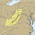
A map showing the proposed state of Westylvania
-
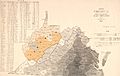
Map of Virginia from 1861, showing slave populations and the proposed state of Kanawha
-
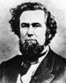
Francis H. Pierpont, a leader during the Second Wheeling Convention
-
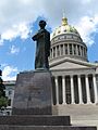
Abraham Lincoln Walks at Midnight, a statue at the West Virginia State Capitol
-
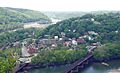
Harpers Ferry changed hands many times during the American Civil War
-
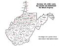
Votes by county in the October 1861 statehood vote
-
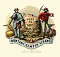
Historical coat of arms of West Virginia (1876)
-
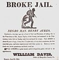
A poster from 1845 about an escaped enslaved person in Hampshire County
-

An enslaved woman caring for a child in West Virginia, 1865
-
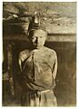
Child labor in West Virginia coal mines, 1908
-

Family of a coal miner, around 1935
-
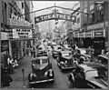
Saturday afternoon street scene in Welch, 1946
-

Bluefield, a major center for coal mining, in 2014
-

A toll plaza on the West Virginia Turnpike
-

The Veterans Memorial Bridge connecting Weirton, WV, to Ohio


_1861_as_first_proposed_(cropped).jpg)


.jpg)


See also
 In Spanish: Virginia Occidental para niños
