Environment of West Virginia facts for kids
The environment of West Virginia is a mix of beautiful landscapes, from flat areas to tall mountains. Most of West Virginia is covered by Appalachian mixed mesophytic forests, which are special types of woodlands. Higher up, near the state's eastern edge, you'll find Appalachian-Blue Ridge forests.
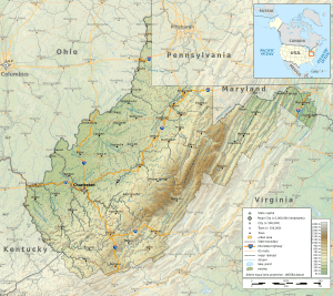
West Virginia is located in the Appalachian Mountains in the eastern part of the United States. It shares borders with Pennsylvania, Maryland, Virginia, Ohio, and Kentucky. A big part of the Appalachian Mountains runs through eastern West Virginia. The tallest mountain in the Allegheny Mountains (a large part of the Appalachians) is Spruce Knob, located in Pendleton County. West Virginia covers about 24,230 square miles (62,750 km²), making it the 41st largest state. It's usually divided into four main areas: the Ohio River Valley, the Allegheny Plateau, the Allegheny Highlands, and the Potomac Section.
Contents
Climate in West Virginia
West Virginia generally has a humid subtropical climate. This means it has warm to hot and humid summers, and cool winters. The weather gets colder the higher up you go in the mountains. Some southern mountain areas have a milder climate, with more moderate winter temperatures and cooler summers. The weather can change quickly across the state.
In the eastern part of the state and along the Ohio River Valley, it's warm enough for some plants that usually grow in warmer, subtropical areas. These include southern magnolia, crepe myrtle, and sweetgum trees.
- In January, average temperatures range from about 26°F (-4°C) near the Cheat River to 41°F (5°C) near the Kentucky border.
- In July, averages range from 67°F (19°C) along the North Branch Potomac River to 76°F (24°C) in the western part of the state. The mountains are always cooler.
- The highest temperature ever recorded was 112°F (44°C) in Martinsburg on July 10, 1936.
- The lowest temperature ever recorded was -37°F (-38°C) in Lewisburg on December 30, 1917.
West Virginia gets a lot of rain and snow. More than half of the rain falls between April and September. Valleys in the east get less rain because the Allegheny mountains block some of the moisture, creating a "rain shadow." Thick fogs are common in many valleys, especially in the Tygart Valley. West Virginia is also one of the cloudiest states. For example, Elkins and Beckley have over 210 cloudy days a year! Snowshoe averages nearly 200 days a year with either rain or snow.
Snow usually melts quickly in lower areas, but it can stay for weeks in the higher mountains. Charleston gets about 34 inches (86 cm) of snow each year. In the Allegheny Highlands, snowfall can be as much as 180 inches (457 cm) per year! Severe weather like tornadoes is less common in West Virginia compared to other eastern states.
Geology: How West Virginia Was Formed
The story of West Virginia's land goes back a very long time! Over a billion years ago, hot lava flowed in the eastern part of the state, forming the oldest rocks we can see today.
Later, about 800 million years ago, a narrow valley began to form in eastern West Virginia. The sea flowed into this valley, and sediment (like sand and mud) started to pile up. Over millions of years, this shallow sea spread westward, covering almost all of West Virginia by the end of the Cambrian period (about 300 million years later).
During this time, for about 370 million years, most of the rocks you see in Jefferson and eastern Berkeley counties were formed from these sea deposits.
- Around the end of the Ordovician period, the Taconic Orogeny (a mountain-building event) created tall mountains east of West Virginia.
- Later, during the Devonian period, another mountain-building event called the Acadian Orogeny created more mountains to the northeast. These events caused a lot of rocky material to be washed into the sea, forming new layers of rock.
- Near the end of the Devonian period, the sea started to disappear from West Virginia, and land-based red rocks were laid down.
The sea returned one more time about 330 million years ago, during the Middle Mississippian period. This led to the formation of the Greenbrier Formation, which is mostly limestone. This was the last time the sea significantly covered West Virginia.
By the early Pennsylvanian Period, about 310 million years ago, West Virginia was mostly dry land. For over 50 million years, the land slowly sank, and new layers of sediment were deposited at about the same rate. During the Permian Period (about 270 to 225 million years ago), the Appalachian Orogeny began, which was a major event that shaped the Appalachian Mountains we see today. The sea has never covered West Virginia since then.
The oldest signs of life in West Virginia are found in rocks about 600 million years old. These ancient Fossils show that life was already quite developed back then. Fossils are found in increasing numbers and show more advanced forms of life in rocks from all periods since the early Cambrian time.
Fauna: Animals of West Virginia
West Virginia is known as the "Mountain State," and its varied landscape, from low-lying valleys to high mountain ridges, creates many different homes for animals.
The state is home to at least 56 different kinds of mammals. You can also find more than 300 types of birds and over 100 species of fish. Many common Insects of the eastern United States live here, including about 15 kinds of beetles, over 70 types of Odonates (like dragonflies), about 18 kinds of spiders, and a dozen kinds of Stoneflys. There are also about 17 types of Moths. In the state's many Caves, you can find over 70 different kinds of invertebrates (animals without backbones).
The West Virginia Division of Wildlife (WVDNR) helps protect animal habitats. They use money from hunting and fishing licenses to do this important work.
Flora: Plants of West Virginia
The Allegheny and Cumberland Plateaus in West Virginia are mostly covered by hardwood forests. However, along the Ohio River and its main branches, much of the valuable timber has been cut down over the centuries to make way for farms and pastures.
Some of the most common trees in these areas include chestnut oaks, walnut trees, yellow poplars, and cherry trees. Southern West Virginia has the largest remaining supply of timber. In the Ridge-and-Valley region, the Eastern Panhandle and Potomac Highlands have forests similar to the plateau. But between these two areas, there's a long stretch where spruce and white pine trees cover the mountain ridges.
Other trees found throughout the state are persimmon, sassafras, and American sycamore (especially in the Ohio and Potomac Valley regions). You'll also find Hickory, chestnut, locust, maple, beech, dogwood, and pawpaw trees.
Common shrubs and vines include blackberry, black and red raspberry, gooseberry, huckleberry, hazel, and wild grape. Ginseng is an important plant used in medicine, and it's mostly harvested in southern West Virginia. Wild ginger, elder, and sumach are also common. Deep in the mountainous areas, you'll see lots of beautiful rhododendrons, mountain laurel, and azaleas.
Geographical Facts About West Virginia
- Highest Point: Spruce Knob on Spruce Mountain in Pendleton County, which is 4,863 feet (1,482 m) above sea level.
- Lowest Point: The Potomac River at Harpers Ferry, which is 240 feet (73 m) above sea level.
- Smallest County: Hancock County, covering 88.2 square miles (229 km²).
- Largest County: Randolph County, covering 1,040 square miles (2,693 km²).
- Oldest County: Hampshire County, created on December 13, 1753.
- Youngest County: Mingo County, created in 1895.
- Most Populous County: Kanawha County, with 200,073 people (as of 2000).
- Least Populous County: Wirt County, with 5,873 people (as of 2000).
- Fastest Growing County: Berkeley County, which grew by 28% between 1990 and 2000.
- Most Populous City: Charleston, with 53,421 people (as of 2000).
- Least Populous City: Thurmond, with only 7 people (as of 2000).
- Oldest City: Romney in Hampshire County, officially recognized on December 23, 1762.
- Geographical Center of State: Near Sutton in Braxton County.
- Center of Population: Near Gassaway in Braxton County.
- West Virginia is the only state with two Panhandles (narrow strips of land sticking out from the main part of the state).
 | Misty Copeland |
 | Raven Wilkinson |
 | Debra Austin |
 | Aesha Ash |


