Cheat River facts for kids
Quick facts for kids Cheat River |
|
|---|---|

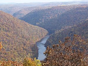
The Cheat River Gorge, as viewed from Cooper's Rock Overlook
|
|

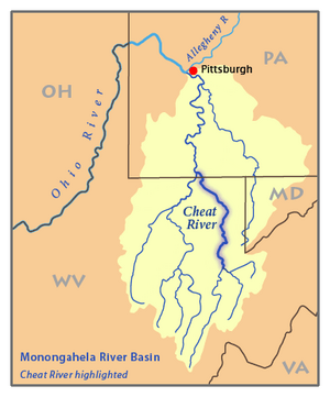
Map of the Monongahela River basin, with the Cheat River highlighted.
|
|
| Country | United States |
| State | Pennsylvania, West Virginia |
| County | Fayette PA, Monongalia WV, Preston WV, Tucker WV |
| Physical characteristics | |
| Main source | Shavers Fork West Virginia 4,620 ft (1,410 m) 38°23′50″N 79°59′09″W / 38.39722°N 79.98583°W |
| 2nd source | Black Fork Hendricks, West Virginia 1,700 ft (520 m) 39°04′20″N 79°37′45″W / 39.07222°N 79.62917°W |
| River mouth | Monongahela River Point Marion, PA 760 ft (230 m) 39°44′34″N 79°54′08″W / 39.74278°N 79.90222°W |
| Length | 78 mi (126 km) |
| Discharge (location 2) |
|
| Basin features | |
| Progression | generally north |
| River system | Monongahela River |
| Basin size | 1,423 sq mi (3,690 km2) |
| Tributaries |
|
The Cheat River is a 78.3-mile-long (126.0 km) river in West Virginia and Pennsylvania, United States. It flows into the Monongahela River. The Monongahela River then joins the Ohio River, and eventually the Mississippi River. This means the Cheat River is part of the huge Mississippi River watershed.
Because it flows through the rugged Allegheny Mountains, much of the Cheat River area is wild and remote. There are not many towns or buildings along its banks. The river starts in the Cheat-Potomac Ranger District of the Monongahela National Forest.
Contents
Exploring the Cheat River
The Cheat River begins in Parsons, West Virginia. It forms where two smaller rivers, Shavers Fork and Black Fork, meet. Black Fork itself gets water from the Blackwater River and three other "Forks": Dry, Glady, and Laurel. These five rivers are often called the "Forks of Cheat."
From Parsons, the Cheat River flows north through Tucker and Preston counties. It passes by towns like Rowlesburg and Albright. After Albright, the river carves an amazing canyon called Cheat Canyon. It then collects water from Big Sandy Creek.
The river then enters Monongalia County. Here, a hydro-electric dam creates a wide area called Cheat Lake. The river then flows a short distance into Fayette County, Pennsylvania. Finally, it joins the Monongahela River at Point Marion, Pennsylvania. The part of the Cheat River above the dam is special because it's one of the largest rivers in the eastern United States without a dam.
A tall, rugged mountain ridge called Cheat Mountain runs for about 50 miles (80 km) near the river.
What's in a Name?
The Delaware (Lenape) Indian people reportedly called the Cheat River Ach-sin-ha-nac. This name meant "stony river."
There are a few ideas about how the name "Cheat River" came to be:
- Some say it was named after a French explorer or an Indian person named Cheat or Chaet.
- Another idea is that it was named for a type of plant called cheat grass that grew along its banks.
- The most common story is that the river has tricky, deep spots and whirlpools. These spots could "cheat" people by being dangerous and causing drownings.
None of these ideas have strong proof, but the last one is told most often.
Older Names for the Cheat River
Over time, the Cheat River has been known by several other names. These include:
- Ach-sin-ha-nac
- Achsinhanac
- Cheal River
- Chealt River
- Eleat River
- Wilmoths River
A Look Back: Cheat River History
The Early Years (1700s)
In 1756, the Eckarly family were the first European settlers in the Cheat River Valley. They settled in a place called Dunkard's Bottom. However, conflicts with Native Americans soon forced them to leave. No one else tried to settle there until after the French and Indian War (1754-1763) ended.
In 1767, Charles Mason and Jeremiah Dixon finished their famous survey of the Mason–Dixon line. This line marks the border between Maryland and Pennsylvania. They extended it to cross the Cheat River.
The Cheat River Valley was part of a large area that Pennsylvania and Virginia both claimed in the 1770s. After more surveys and agreements, it was decided that almost all of the Cheat River was within Virginia. Later, in 1863, the Cheat River Valley became part of the new state of West Virginia.
Changes in the 1800s
In 1806, the Virginia government allowed the first two ferries to operate on the Cheat River. Ferries helped people cross the river. They also approved building mill dams on the Cheat and other rivers. These dams helped power mills.
The Great Flood of 1985
In November 1985, very heavy rains caused a huge flood on the Cheat River. The small town of Albright was almost completely destroyed. The river's flow was estimated to be 190,000 cubic feet per second. This is much, much larger than its normal flow, which is usually between 1,000 and 5,000 cubic feet per second.
The flood also caused the Cheat River to overflow its banks in Rowlesburg. Many businesses were lost, and families had to leave their homes. The flood also destroyed the school in Rowlesburg. This led to schools in the county combining. The main problem was not just the amount of water. It was also because debris (like trees and parts of buildings) got stuck under bridges. This created temporary dams. When these dams broke, a huge rush of water and debris would crash down the river, causing even more damage at the next bridge.
River Health: Pollution and Cleanup

Near Albright, the Cheat River has faced pollution problems. A big issue has been acid mine drainage. This is polluted water that comes from old mines. This pollution has stained the rocks downstream a rusty brown color. It also caused the river to have very few fish below Albright.
However, the water quality has been slowly getting better since the 1990s. A local group called Friends of the Cheat has worked hard to help. They promote cleaning up the river, taking care of it, and teaching people about its importance.
Fun on the Water: Whitewater Adventures
The Cheat Canyon part of the Cheat River is a popular spot for whitewater kayaking and rafting. This section has exciting rapids, some of which are Class IV (and even Class V when the water is high).
Every year on the first weekend in May, people from many states come together for the Cheat Festival. A very popular whitewater race, the Cheat River Race, happens on the Friday of that weekend. This race is special because all participants start at the same time, unlike most whitewater races. For the first few miles, paddlers have to avoid each other and the river's challenges. This race often has about 150 people and is known as one of the biggest whitewater races around!
The Cheat Narrows section of the river, which is upstream from Albright, is also used by whitewater paddlers. It has Class II and III rapids, which are a bit easier but still fun.
 | Roy Wilkins |
 | John Lewis |
 | Linda Carol Brown |


