Point Marion, Pennsylvania facts for kids
Quick facts for kids
Point Marion, Pennsylvania
|
|
|---|---|
|
Borough
|
|
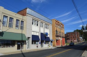
Penn Street in downtown Point Marion
|
|
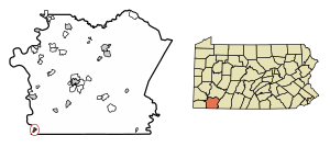
Location of Point Marion in Fayette County, Pennsylvania.
|
|
| Country | United States |
| State | Pennsylvania |
| County | Fayette |
| Established | 1842 |
| Area | |
| • Total | 0.49 sq mi (1.27 km2) |
| • Land | 0.41 sq mi (1.05 km2) |
| • Water | 0.08 sq mi (0.22 km2) |
| Elevation | 810 ft (250 m) |
| Population
(2020)
|
|
| • Total | 1,156 |
| • Density | 2,854.32/sq mi (1,101.94/km2) |
| Time zone | UTC-4 (EST) |
| • Summer (DST) | UTC-5 (EDT) |
| ZIP code |
15474
|
| Area code(s) | 724 |
Point Marion is a small town, called a borough, in Fayette County, Pennsylvania. It is located very close to West Virginia. This town sits where two rivers meet: the Monongahela and the Cheat.
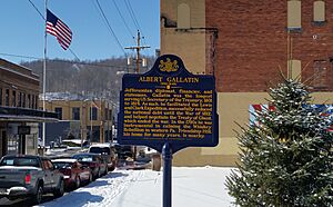
Just a few miles north of Point Marion is Friendship Hill National Historic Site. This was once the home of Albert Gallatin, an important early American politician. Point Marion was settled in the mid-1700s. It got its name in 1842. The name comes from its location (the "point" where rivers meet) and Francis Marion, a hero from the Revolutionary War known as the "Swamp Fox."
In 2020, about 1,152 people lived in Point Marion. This number was a little lower than in 2010. The town is part of the Albert Gallatin Area School District.
Contents
History of Point Marion
Early Inhabitants
The first people to live in this area were Native American tribes. They belonged to the Monongahela culture. These tribes lived here from about 1050 AD to 1635 AD. You can still find signs of their ancient villages nearby.
By the mid-1600s, the Shawnee tribe moved into western Pennsylvania. This included the area that would become Point Marion. It was known as the "Hunting Grounds" for these tribes.
European Settlers Arrive
The first Europeans came to Point Marion in 1723. A French trader named Jacques Cheathe made a deal with the local Native Americans. He set up a trading post and became the first European settler.
More settlers, both English and German, arrived in 1751. After the French and Indian War ended in 1763, Great Britain took control of the region.
Mapping the Land
In 1767, two English surveyors, Mason and Dixon, worked near Point Marion. They were mapping the southern border of Pennsylvania. They crossed the Cheat and Monongahela rivers. Their work helped define the state lines.
At first, Point Marion was part of Virginia. But after the American Revolutionary War, it became part of Pennsylvania. This happened in 1783 when Fayette County was created.
An old church, the Forks of Cheat Baptist Church, was founded nearby in 1775. It is one of the oldest churches still active west of the Allegheny Mountains. Its name refers to the fork of the Cheat and Monongahela rivers.
George Washington's Visit
In 1784, George Washington, who later became the first U.S. President, visited the area. He was checking on land he owned. Washington wrote in his journal about the two rivers. He noted how the Cheat River was dark and the Monongahela was clear.
At that time, Point Marion did not exist as a town. But the Monongahela River was important for travel. Travelers could stop at Morgan's Tavern near the river.
Albert Gallatin and Friendship Hill
Just four years after Washington's visit, Albert Gallatin bought land nearby. He was a Swiss immigrant who became a U.S. Secretary of the Treasury. He built his home, Friendship Hill, which is now a national historic site.
General Lafayette, for whom Fayette County is named, also visited Gallatin. Gallatin's name is still honored by the Albert Gallatin Area School District.
Point Marion Becomes a Town
In 1801, the land at the point was sold to Jacob Sadler. It was later divided into smaller pieces. On March 15, 1842, these pieces were sold to the public. The first buyer, Seth Stafford, got to choose the town's name. He chose "Point Marion" after the Revolutionary War hero, General Francis Marion.
In 1844, Point Marion officially became a "Borough."
River Travel and Growth
In 1847, a ferry service started across the river. This helped people travel between counties. The ferry ran until 1931, when bridges made it unnecessary.
By 1867, Point Marion was growing. Its main business was lumber. Logs were floated down the Cheat River to be processed. The Monongahela River was key for transporting goods.
In 1879, the Point Marion lock was built on the river. This made river travel easier all year. Because of better river and railroad access, Point Marion became a popular summer spot. People from Pittsburgh visited, and hotels and restaurants were built. Steamboats with entertainment often came to town.
In 1890, the McClain brothers started a sand and gravel business. They supplied materials for the railroad and other projects. Their business used barges and steamboats on the rivers.
The 1900s: Industry and Change
A building boom started in 1900, creating a town center. In 1907, Penn Street became the first paved street. Italian immigrants helped with much of this construction. A big fire in 1922 destroyed many buildings, but they were rebuilt.
The glass industry also began in Point Marion in 1900. Many skilled glassmakers from Belgium came to work here. These French-speaking immigrants founded Saint Hubert’s Catholic Church in 1909.
In 1923, Leon Houze, also from Belgium, combined several glass companies. He formed the Houze Convex Glass Company. This became the town's largest employer for over 100 years. Houze Glass made special glass products. Their windows were even in the White House in the 1950s. They made lamps for Woolworths and trays for President Nixon.
The Cheat River Bridge opened in 1909. This was the first bridge into Point Marion. In 1910, plans began for the Lake Lynn Dam and Power Station. This project created Cheat Lake and started producing power in 1926.
In 1926, a new Point Marion Lock and Dam opened on the Monongahela River. It is still used today.
The Albert Gallatin Memorial Bridge was built in 1930. This bridge connected Point Marion directly to Greene County. In 1937, President Franklin D. Roosevelt's train even passed through the town.
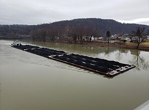
In 1967, the Fort Martin Power Plant opened nearby. It created jobs and changed the landscape. More tugboats carrying coal began traveling the river.
Point Marion Today
Today, Point Marion is still connected to both Pennsylvania and West Virginia. Some people who work in Morgantown, West Virginia, live in Point Marion.
In the early 2000s, both bridges built in the early 1900s were replaced. The old Baltimore and Ohio Railroad line was turned into the Sheepskin Trail in 2008. This is now a path for walking and biking.
In 2011, the Longview Power Plant started operating nearby. This also changed the local scenery.
Recently, more wildlife has been seen around Point Marion. You might spot bald eagles, Canada geese, wild turkeys, coyotes, and even black bears. Bald eagles and Canada geese now live along the Cheat River all year.
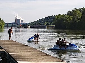
Like many small towns, Point Marion is quieter than it used to be. There are fewer local businesses. However, the Boat Launch at the town park is still popular. People come to boat and fish. Town events like the annual car show and the "Albert Gallatin Regatta" keep the community active. The regatta includes a parade and fireworks.
Geography
Point Marion is in the southwestern part of Fayette County. It is located where the Cheat and Monongahela rivers meet. The Cheat River forms the town's northeastern border. The Monongahela River forms its western border and separates it from Greene County.
U.S. Route 119 goes through Point Marion. It leads northeast about 17 miles to Uniontown. This is the main town of Fayette County. Route 119 also goes south about 10 miles to Morgantown, West Virginia. The border with West Virginia is about 1.5 miles south of the town center.
Pennsylvania Route 88 crosses the Monongahela River from Point Marion. It goes north about 14 miles to Carmichaels.
The United States Census Bureau says Point Marion covers about 0.49 square miles (1.27 square kilometers). Most of this area is land, but about 15.77% is water.
Demographics
| Historical population | |||
|---|---|---|---|
| Census | Pop. | %± | |
| 1880 | 28 | — | |
| 1900 | 575 | — | |
| 1910 | 1,389 | 141.6% | |
| 1920 | 1,607 | 15.7% | |
| 1930 | 2,039 | 26.9% | |
| 1940 | 2,068 | 1.4% | |
| 1950 | 2,197 | 6.2% | |
| 1960 | 1,853 | −15.7% | |
| 1970 | 1,750 | −5.6% | |
| 1980 | 1,642 | −6.2% | |
| 1990 | 1,344 | −18.1% | |
| 2000 | 1,333 | −0.8% | |
| 2010 | 1,159 | −13.1% | |
| 2020 | 1,152 | −0.6% | |
| 2021 (est.) | 1,135 | −2.1% | |
| Sources: | |||
Based on the 2000 census, Point Marion had 1,333 people. There were 572 households, and 374 families lived in the borough. The population density was about 3,142 people per square mile.
About 22.3% of the people were under 18 years old. About 20.3% were 65 years or older. The average age in the borough was 40 years. For every 100 females, there were about 102 males.
See also
 In Spanish: Point Marion para niños
 | Claudette Colvin |
 | Myrlie Evers-Williams |
 | Alberta Odell Jones |


