
Preston County, West Virginia facts for kids
Quick facts for kids
Preston County
|
|||
|---|---|---|---|
|
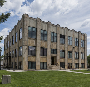
Preston County Courthouse
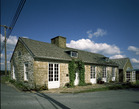
James Clark McGrew House in Kingwood
|
|||
|
|||

Location of Preston County in West Virginia
|
|||

West Virginia's location within the U.S.
|
|||
| Country | |||
| State | |||
| Founded | January 19, 1818 | ||
| Named for | James Patton Preston | ||
| Seat | Kingwood | ||
| and Largest city | |||
| Area | |||
| • Total | 1,690 km2 (651 sq mi) | ||
| • Land | 1,680 km2 (649 sq mi) | ||
| • Water | 7 km2 (2.6 sq mi) 0.4% | ||
| Area rank | 8th | ||
| Population
(2020)
|
|||
| • Total | 34,216 | ||
| • Estimate
(2021)
|
34,358 |
||
| • Rank | 15th | ||
| • Density | 20.293/km2 (52.56/sq mi) | ||
| Time zone | UTC−5 (Eastern) | ||
| • Summer (DST) | UTC−4 (EDT) | ||
| Area code(s) | 304, 681 | ||
| Congressional district | 2nd | ||
| Senate district | 14th | ||
| House of Delegates district | 83rd, 84th | ||
| Website | http://www.prestoncountywv.org/ | ||


Preston County is a place in West Virginia, USA. In 2020, about 34,216 people lived there. Its main town, called the county seat, is Kingwood.
The county was created in 1818 from Monongalia County. It was named after James Patton Preston, who was a governor of Virginia. Preston County is near Morgantown and is also part of the Pittsburgh media area. It is famous for The Buckwheat Festival, a county fair known for making delicious buckwheat pancakes.
Contents
History of Preston County
Native Americans lived in and traveled through the area that is now Preston County. They moved between the Ohio River and the Chesapeake Bay areas. European traders and explorers started living here around 1736. A special stone, the Fairfax Stone, was placed in 1746 to mark a boundary.
More white settlers began arriving in 1766, especially after the American Revolutionary War. These settlers traveled by foot or horseback and built their own log cabins. The county grew more after 1818 when the National Road was built nearby. When the first railroads arrived in 1851, the population grew by 70% in just ten years, and industries began to develop.
Preston County During the Civil War
During the American Civil War, more men from Preston County joined the Union army than the Confederate army. There were very few slave owners in Preston County, and therefore, very few enslaved people. Records from 1830 show that Preston County had 125 enslaved people and 27 free Black people. This was the highest number of enslaved people ever recorded in the county.
On June 20, 1863, Preston County became part of the new state of West Virginia. West Virginia was formed from 50 counties that separated from Virginia and joined the Union. Later that year, counties were divided into smaller areas called townships to help with local government. This didn't work well in rural West Virginia, so in 1872, townships became "magisterial districts." Preston County had eight districts: Grant, Kingwood, Lyon, Pleasant, Portland, Reno, Union, and Valley. These stayed mostly the same until the 1990s, when they were combined into five new districts.
Geography of Preston County
Preston County covers about 651 square miles. Most of this (649 square miles) is land, and a small part (2.6 square miles) is water.
In January 1977, Terra Alta in Preston County had a record snowfall of 104 inches. This was the most snow recorded in West Virginia during that month.
Main Roads in Preston County
 Interstate 68
 U.S. Highway 50
 U.S. Route 219
 West Virginia Route 7
 West Virginia Route 24
 West Virginia Route 26
 West Virginia Route 72
 West Virginia Route 92
Neighboring Counties
Preston County shares borders with these other counties:
- Fayette County, Pennsylvania (north)
- Garrett County, Maryland (east)
- Tucker County (south)
- Barbour County (southwest)
- Taylor County (west)
- Monongalia County (northwest)
- Grant County (southeast)
Protected Natural Areas
- Monongahela National Forest (part)
- Cathedral State Park (also a National Natural Landmark)
- Fairfax Stone State Park
People of Preston County
| Historical population | |||
|---|---|---|---|
| Census | Pop. | %± | |
| 1820 | 3,422 | — | |
| 1830 | 5,144 | 50.3% | |
| 1840 | 6,866 | 33.5% | |
| 1850 | 11,708 | 70.5% | |
| 1860 | 13,312 | 13.7% | |
| 1870 | 14,555 | 9.3% | |
| 1880 | 19,091 | 31.2% | |
| 1890 | 20,355 | 6.6% | |
| 1900 | 22,727 | 11.7% | |
| 1910 | 26,341 | 15.9% | |
| 1920 | 27,996 | 6.3% | |
| 1930 | 29,043 | 3.7% | |
| 1940 | 30,416 | 4.7% | |
| 1950 | 31,399 | 3.2% | |
| 1960 | 27,233 | −13.3% | |
| 1970 | 25,455 | −6.5% | |
| 1980 | 30,460 | 19.7% | |
| 1990 | 29,037 | −4.7% | |
| 2000 | 29,334 | 1.0% | |
| 2010 | 33,520 | 14.3% | |
| 2020 | 34,216 | 2.1% | |
| 2021 (est.) | 34,358 | 2.5% | |
| U.S. Decennial Census 1790–1960 1900–1990 1990–2000 2010–2020 |
|||
2020 Census Information
In 2020, there were 34,216 people living in Preston County. There were 12,510 households, which are groups of people living together. Most people (90.1%) were White. About 6% were African American, and smaller numbers were Asian or Native American. About 2% of the population was Hispanic or Latino.
The average household had 3.04 people. The average age in the county was 43.5 years old. About 19% of the people were under 18. The average income for a household was $55,755. About 14.4% of the people lived below the poverty line.
2010 Census Information
In 2010, there were 33,520 people in Preston County. Most people (97.6%) were White. About 1.1% were Black or African American. The main backgrounds of people included German (29.4%), Irish (14.3%), American (9.5%), and English (8.9%).
About 29% of households had children under 18. The average age was 42.0 years. The average income for a household was $40,753. About 13.9% of the population lived below the poverty line.
Towns and Communities
City
- Kingwood (the county seat)
Towns
Magisterial Districts
These are areas within the county used for local government.
Current Districts
- First
- Second
- Third
- Fourth
- Fifth
Historic Districts
- Grant
- Kingwood
- Lyon
- Pleasant
- Portland
- Reno
- Union
- Valley
Census-Designated Place
Unincorporated Communities
These are smaller communities that are not officially cities or towns.
- Afton
- Alpine Lake
- Amboy
- Arthurdale
- Austen
- Borgman
- Bretz
- Bull Run
- Cascade
- Clifton Mills
- Colebank
- Corinth
- Cuzzart
- Denver
- Eglon
- Etam
- Evansville
- Fellowsville
- Gladefarms
- Hardman (partial)
- Hazelton
- Herring
- Hopemont
- Hopewell
- Horse Shoe Run
- Howesville
- Independence
- Lenox
- Little Sandy
- Manheim
- Macomber
- Manown
- Marquess
- Mount Olivet
- Mount Vernon
- Orr
- Pisgah
- Pleasantdale
- Preston
- Rockville
- Rodemer
- Rohr
- Ruthbelle
- Saint Joe
- Scotch Hill
- Sell
- Silver Lake
- Sinclair
- Snider
- Stevensburg
- Sugar Valley
- Thornton
- Threefork Bridge
- Turner Douglass
- Valley Point
- Victoria
- West End
- White Oak Springs
- Zevely
Images for kids
-
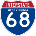
Interstate 68 sign
-
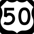
U.S. Highway 50 sign
-
U.S. Route 219 sign
-

West Virginia Route 7 sign
-

West Virginia Route 24 sign
-

West Virginia Route 26 sign
-
West Virginia Route 72 sign
-

West Virginia Route 92 sign
.svg)


See also
 In Spanish: Condado de Preston para niños
