Brandonville, West Virginia facts for kids
Quick facts for kids
Brandonville, West Virginia
|
|
|---|---|

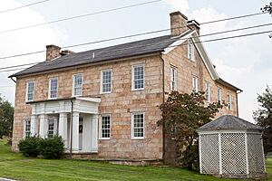
Hagans Homestead (1830)
|
|

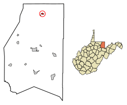
Location of Brandonville in Preston County, West Virginia.
|
|
| Country | United States |
| State | West Virginia |
| County | Preston |
| Area | |
| • Total | 0.39 sq mi (1.00 km2) |
| • Land | 0.39 sq mi (1.00 km2) |
| • Water | 0.00 sq mi (0.00 km2) |
| Elevation | 1,805 ft (550 m) |
| Population
(2020)
|
|
| • Total | 136 |
| • Estimate
(2021)
|
136 |
| • Density | 272.73/sq mi (105.19/km2) |
| Time zone | UTC-5 (Eastern (EST)) |
| • Summer (DST) | UTC-4 (EDT) |
| ZIP code |
26525
|
| Area code(s) | 304 |
| FIPS code | 54-09844 |
| GNIS feature ID | 1553965 |
| Website | https://local.wv.gov/brandonville/Pages/default.aspx |
Brandonville is a small town in the northern part of Preston County, West Virginia, United States. In 2020, about 136 people lived there. It is part of the larger Morgantown metropolitan area.
Contents
History of Brandonville
Brandonville was created in 1827 by a person named Jonathan Brandon. The town was named after him.
A historic building called the Hagans Homestead was added to the National Register of Historic Places in 1993. This means it is an important place to protect.
In 1987, the town's mayor, Clarence Fike, made news around the world. For the town's election, he gave out ballots that did not have any names on them. He told everyone that they could vote for themselves. This was a very unusual way to hold an election!
Where is Brandonville?
Brandonville is located at 39°39′59″N 79°37′17″W / 39.66639°N 79.62139°W.
The United States Census Bureau says the town covers about 0.39 square miles (1.00 square kilometer). All of this area is land.
People Living in Brandonville
| Historical population | |||
|---|---|---|---|
| Census | Pop. | %± | |
| 1860 | 165 | — | |
| 1870 | 100 | −39.4% | |
| 1880 | 107 | 7.0% | |
| 1890 | 82 | −23.4% | |
| 1900 | 68 | −17.1% | |
| 1910 | 96 | 41.2% | |
| 1920 | 67 | −30.2% | |
| 1930 | 82 | 22.4% | |
| 1940 | 113 | 37.8% | |
| 1950 | 100 | −11.5% | |
| 1960 | 109 | 9.0% | |
| 1970 | 82 | −24.8% | |
| 1980 | 92 | 12.2% | |
| 1990 | 73 | −20.7% | |
| 2000 | 102 | 39.7% | |
| 2010 | 101 | −1.0% | |
| 2020 | 136 | 34.7% | |
| 2021 (est.) | 136 | 34.7% | |
| U.S. Decennial Census | |||
Brandonville in 2010
In 2010, there were 101 people living in Brandonville. These people lived in 47 households, and 29 of those were families. The town had about 259 people per square mile.
Most of the people in town, 95%, were White. About 5% were from other backgrounds. Also, 5% of the people were Hispanic or Latino.
- About 23% of households had children under 18 living with them.
- Around 43% were married couples living together.
- About 15% had a female head of household with no husband.
- Around 4% had a male head of household with no wife.
- About 38% were not families.
The average household had 2.15 people. The average family had 2.62 people.
The average age in Brandonville was 41.9 years old.
- About 18% of residents were under 18.
- 6% were between 18 and 24.
- Nearly 29% were between 25 and 44.
- About 24% were between 45 and 64.
- Another 24% were 65 or older.
The town had slightly more females (52.5%) than males (47.5%).
Famous People from Brandonville
- George Bird Evans: He was an artist, wrote mystery novels, and wrote about hunting dogs. He also bred dogs.
- Mrs. A. Elmore: She was a writer, editor, and worked to promote temperance (avoiding alcohol). She also helped others.
See also
 In Spanish: Brandonville (Virginia Occidental) para niños
 | Isaac Myers |
 | D. Hamilton Jackson |
 | A. Philip Randolph |

