Rowlesburg, West Virginia facts for kids
Quick facts for kids
Rowlesburg, West Virginia
|
||
|---|---|---|

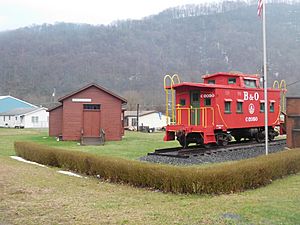
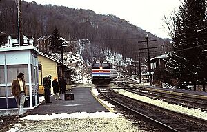
The former Baltimore and Ohio Railroad and Amtrak station in March 2017
|
||
|
||

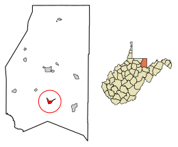
Location of Rowlesburg in Preston County, West Virginia.
|
||
| Country | United States | |
| State | West Virginia | |
| County | Preston | |
| Area | ||
| • Total | 1.10 sq mi (2.84 km2) | |
| • Land | 1.01 sq mi (2.62 km2) | |
| • Water | 0.09 sq mi (0.22 km2) | |
| Elevation | 1,385 ft (422 m) | |
| Population
(2020)
|
||
| • Total | 438 | |
| • Density | 565.78/sq mi (218.55/km2) | |
| Time zone | UTC-5 (Eastern (EST)) | |
| • Summer (DST) | UTC-4 (EDT) | |
| ZIP code |
26425
|
|
| Area code(s) | 304 | |
| FIPS code | 54-70588 | |
| GNIS feature ID | 1552749 | |
| Website | https://www.townofrowlesburg.com/ | |
Rowlesburg is a small town in Preston County, West Virginia, United States. It is located along the Cheat River. In 2020, about 438 people lived there. Rowlesburg is part of the larger Morgantown metropolitan area.
This town used to be very important for railroads. It is home to the Downtown Rowlesburg Historic District, which has many old and important buildings. Rowlesburg also played a role in the American Civil War.
Contents
History of Rowlesburg
Rowlesburg became an official town in 1858. It was named after Thomas Rowles, who was a railroad engineer.
Rowlesburg During the Civil War
During the American Civil War, Rowlesburg was very important. It had two Baltimore and Ohio Railroad bridges. These bridges crossed the Cheat River and Tray Run. They were key for moving supplies and soldiers.
In 1861, Confederate troops tried to reach Rowlesburg but failed. Later, in 1863, Confederate General William E. Jones led a raid that reached the town. However, Union soldiers and local townsmen worked together. They defended the town and the important railroad lines. General Jones had to retreat.
Historic Downtown Area
The Downtown Rowlesburg Historic District is a special area in town. It was added to the National Register of Historic Places in 2005. This means it has many buildings and places that are important to history.
Geography and Location
Rowlesburg is located at 39°21′0″N 79°40′22″W / 39.35000°N 79.67278°W.
The United States Census Bureau says the town covers about 1.10 square miles (2.84 square kilometers). Most of this area is land, with a small part being water.
Rowlesburg's Climate
Rowlesburg has a climate where summers are warm and winters are cold. It gets enough rain all year round. In winter, the rain often turns into snow or sleet. This type of weather is called a continental climate.
| Climate data for Rowlesburg, West Virginia (1991–2020 normals, extremes 1942–present) | |||||||||||||
|---|---|---|---|---|---|---|---|---|---|---|---|---|---|
| Month | Jan | Feb | Mar | Apr | May | Jun | Jul | Aug | Sep | Oct | Nov | Dec | Year |
| Record high °F (°C) | 80 (27) |
79 (26) |
85 (29) |
93 (34) |
92 (33) |
98 (37) |
98 (37) |
98 (37) |
101 (38) |
93 (34) |
83 (28) |
80 (27) |
101 (38) |
| Mean daily maximum °F (°C) | 38.3 (3.5) |
42.5 (5.8) |
51.4 (10.8) |
64.2 (17.9) |
72.3 (22.4) |
79.1 (26.2) |
82.2 (27.9) |
81.7 (27.6) |
76.2 (24.6) |
65.0 (18.3) |
53.1 (11.7) |
42.5 (5.8) |
62.4 (16.9) |
| Daily mean °F (°C) | 29.3 (−1.5) |
32.4 (0.2) |
40.1 (4.5) |
50.8 (10.4) |
60.2 (15.7) |
67.9 (19.9) |
71.8 (22.1) |
71.0 (21.7) |
64.9 (18.3) |
53.2 (11.8) |
42.1 (5.6) |
33.9 (1.1) |
51.5 (10.8) |
| Mean daily minimum °F (°C) | 20.2 (−6.6) |
22.2 (−5.4) |
28.7 (−1.8) |
37.4 (3.0) |
48.1 (8.9) |
56.7 (13.7) |
61.3 (16.3) |
60.4 (15.8) |
53.6 (12.0) |
41.4 (5.2) |
31.2 (−0.4) |
25.3 (−3.7) |
40.5 (4.7) |
| Record low °F (°C) | −21 (−29) |
−19 (−28) |
−5 (−21) |
12 (−11) |
22 (−6) |
32 (0) |
40 (4) |
38 (3) |
29 (−2) |
11 (−12) |
0 (−18) |
−13 (−25) |
−21 (−29) |
| Average precipitation inches (mm) | 4.37 (111) |
4.10 (104) |
5.00 (127) |
4.93 (125) |
5.44 (138) |
5.49 (139) |
6.57 (167) |
4.71 (120) |
4.37 (111) |
3.89 (99) |
3.72 (94) |
4.67 (119) |
57.26 (1,454) |
| Average snowfall inches (cm) | 19.7 (50) |
13.3 (34) |
10.2 (26) |
0.8 (2.0) |
0.0 (0.0) |
0.0 (0.0) |
0.0 (0.0) |
0.0 (0.0) |
0.0 (0.0) |
0.1 (0.25) |
2.2 (5.6) |
10.6 (27) |
56.9 (145) |
| Average precipitation days (≥ 0.01 in) | 18.6 | 14.7 | 15.0 | 13.9 | 15.0 | 13.8 | 13.8 | 12.0 | 11.6 | 11.4 | 12.8 | 17.4 | 170.0 |
| Average snowy days (≥ 0.1 in) | 9.0 | 7.2 | 3.8 | 1.0 | 0.0 | 0.0 | 0.0 | 0.0 | 0.0 | 0.1 | 1.4 | 7.1 | 29.6 |
| Source: NOAA | |||||||||||||
Flood History
The Cheat River at Rowlesburg is considered to be flooding when the water level reaches 16 feet. Here are some of the highest flood levels recorded:
| Date | Gauge Height in feet |
|---|---|
| July 6, 1844 | 24.30 |
| July 18, 1888 | 23.6 |
| October 16, 1954 | 24.05 |
| November 4, 1985 | 36.9 |
| February 9, 1994 | 23.9 |
| May 8, 1994 | 20.94 |
| January 19, 1996 | 25.40 |
| May 17, 1996 | 17.5 |
| July 19, 1996 | 19.5 |
Population and People
| Historical population | |||
|---|---|---|---|
| Census | Pop. | %± | |
| 1880 | 402 | — | |
| 1890 | 560 | 39.3% | |
| 1900 | 652 | 16.4% | |
| 1910 | 936 | 43.6% | |
| 1920 | 1,225 | 30.9% | |
| 1930 | 1,573 | 28.4% | |
| 1940 | 1,452 | −7.7% | |
| 1950 | 1,299 | −10.5% | |
| 1960 | 970 | −25.3% | |
| 1970 | 829 | −14.5% | |
| 1980 | 966 | 16.5% | |
| 1990 | 648 | −32.9% | |
| 2000 | 613 | −5.4% | |
| 2010 | 584 | −4.7% | |
| 2020 | 438 | −25.0% | |
| U.S. Decennial Census | |||
What the 2010 Census Showed
The census in 2010 counted 584 people living in Rowlesburg. There were 255 households, and 163 of these were families. The town had about 578 people per square mile.
Most of the people (99.5%) were White. A very small number were from other races or mixed races.
- 23.1% of households had children under 18.
- 51.4% were married couples.
- About 36.1% were not families.
- 32.9% of households had only one person living there.
- 19.2% of households had someone 65 years or older living alone.
The average age in Rowlesburg was 48 years old.
- 18.8% of residents were under 18.
- 5.7% were between 18 and 24.
- 20.4% were between 25 and 44.
- 35.1% were between 45 and 64.
- 20% were 65 or older.
The town had slightly more females (51.7%) than males (48.3%).
Famous People From Rowlesburg
- William G. Brown Sr. (1800–1884), a politician and lawyer.
- Jock Menefee (1868–1953), a baseball pitcher.
See also
 In Spanish: Rowlesburg (Virginia Occidental) para niños
 | Anna J. Cooper |
 | Mary McLeod Bethune |
 | Lillie Mae Bradford |


