
Garrett County, Maryland facts for kids
Quick facts for kids
Garrett County
|
|||
|---|---|---|---|

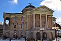
Garrett County Courthouse in December 2013
|
|||
|
|||

Location within the U.S. state of Maryland
|
|||
 Maryland's location within the U.S. |
|||
| Country | |||
| State | |||
| Founded | November 4, 1872 | ||
| Named for | John Work Garrett | ||
| Seat | Oakland | ||
| Largest town | Mountain Lake Park | ||
| Area | |||
| • Total | 656 sq mi (1,700 km2) | ||
| • Land | 647 sq mi (1,680 km2) | ||
| • Water | 8.6 sq mi (22 km2) 1.3% | ||
| Population
(2020)
|
|||
| • Total | 28,806 | ||
| • Estimate
(2023)
|
28,423 |
||
| • Density | 43.91/sq mi (16.954/km2) | ||
| Time zone | UTC−5 (Eastern) | ||
| • Summer (DST) | UTC−4 (EDT) | ||
| Congressional district | 6th | ||


Garrett County (/ɡɛrɪt/) is the westernmost county in the state of Maryland. It is completely located within the Appalachian Mountains. In 2020, about 28,806 people lived here. This makes it the third least populated county in Maryland.
The main town, or county seat, is Oakland. The county is named after John W. Garrett, who was the president of the Baltimore and Ohio Railroad. Garrett County was formed from Allegany County in 1872. It was the very last county created in Maryland.
Garrett County is part of the Western Maryland region. It shares borders with four counties in West Virginia. To the north, it meets the Maryland–Pennsylvania border, known as the Mason–Dixon line. The Potomac River and the state of West Virginia are to the south and west.
The county is in the Allegheny Mountains, which are part of the larger Appalachian Mountain Range. The highest point in Maryland, called Hoye-Crest, is in Garrett County. It's on Backbone Mountain and stands at 3,360 feet high.
An important natural feature is the Eastern Continental Divide. This line runs along parts of Backbone Mountain. Water on the west side of this divide flows towards the Mississippi River. Water on the east side flows towards the Chesapeake Bay. Garrett County is the only part of Maryland where water flows into the Mississippi River system.
There are 20 historic places in Garrett County listed on the National Register of Historic Places. One of these is the Casselman Bridge, National Road, which is a very important national landmark.
Contents
History of Garrett County

In the early 1900s, the popularity of railroads and tourism started to decrease. Coal mining and timber production also slowed down. Today, tourism has grown a lot in the county. Logging and farming are also big parts of the local economy. Garrett County has a cool climate and no very large cities. Because of this, it has remained a quiet, rural area with fewer people.
Exploring Garrett County's Geography
Garrett County covers a total area of 656 square miles. About 647 square miles are land, and 8.6 square miles are water. It is the second largest county in Maryland by land area.
The county is entirely within the Appalachian Mountains. This area is also called the Allegheny Mountains or the Allegheny Plateau. The highest points are along four flat-topped ridges. The highest is Hoye-Crest on Backbone Mountain, which is 3,360 feet (1,024 meters) high. Below these ridges, you'll find wide flat areas about 500 feet (152 meters) lower. River valleys are usually narrow and deep, often 1,000 to 1,800 feet (305 to 549 meters) below the nearby peaks.
Garrett County has over 76,000 acres of parks, lakes, and public forests. Two main river systems drain the county: the Potomac and the Youghiogheny. The Savage River, which flows into the Potomac, drains about one-third of the county. The Casselman River flows north into Pennsylvania and then joins the Youghiogheny. The Youghiogheny River itself drains the western part of the county. It also flows north into Pennsylvania, eventually joining the Monongahela River near Pittsburgh.
Cool Geological Spots
The Glades
The Glades cover 601 acres and are very interesting to scientists. This area is a special type of wetland called an "ombrotrophic system." This means it gets all its water only from rainwater. It has peat layers up to 9 feet thick. It is one of the oldest mountain peatlands in the Appalachians.
Near Bittinger, Maryland, which is named after its first settler, you can find one of the largest "glades" areas. This area seems to have been shaped by the last great ice sheet in North America. There is a large deposit of peat moss nearby.
Loess Dunes
In the Casselman River valley, about one mile south of Grantsville, Maryland, you can see signs of the last great ice sheet. There are low mounds in the fields that are made of "loess." Loess is fine earth blown by the wind. These are believed to be the only ones still visible in northern Garrett County.
These mounds formed when a glacier lake was in the Casselman valley. As the ice around the lake melted, wind blew fine dirt into the water. This dirt sank to the bottom, creating the mounds we see today.
Mountains of Garrett County
| Mountain | Elevation (feet) |
|---|---|
| Backbone Mountain | 3,360 |
| Big Savage Mountain | 2,991 |
| Blossom Hill | 2,620 |
| Contrary Knob | 2,680 |
| Conway Hill | 2,760 |
| Dung Hill | 2,732 |
| Elbow Mountain | 2,694 |
| Elder Hill | 2,826 |
| Fort Hill | 2,600 |
| George Mountain | 3,004 |
| Lewis Knob | 2,960 |
| Little Mountain | 2,920 |
| Little Savage Mountain | 2,817 |
| Marsh Hill | 3,073 |
| Meadow Mountain | 2,959 |
| Mount Nebo | 2,604 |
| Negro Mountain | 3,075 |
| Pine Hill | 2,500 |
| Rich Hill | 2,842 |
| Ridgley Hill | 2,617 |
| River Hill | 2,700 |
| Roman Nose Mountain | 3,140 |
| Roth Rock Mountain | 2,860 |
| Salt Block Mountain | 2,707 |
| Snaggy Hill | 3,040 |
| Walnut Hill | 2,629 |
| Winding Ridge | 2,775 |
| Whites Knob | 2,940 |
| Zehner Hill | 3,000 |
Creeks of Garrett County
- Bear Creek
- Beaver Creek
- Cherry Creek
- Church Creek
- Crabtree Creek
- Deep Creek (formerly Green Glades Creek)
- Fork Creek
- Georges Creek
- Herrington Creek
- Middle Fork Creek
- Muddy Creek
- North Fork Creek
- Rhine Creek
- Snowy Creek
- South Fork Crabtree Creek
- South Fork Creek
Lakes of Garrett County
- Deep Creek Lake is the largest freshwater body in Maryland. It is 11.6 miles (18.7 km) long.
Waterfalls of Garrett County
- Gap Falls
- Muddy Creek Falls is the highest free-falling waterfall in Maryland at 54 feet.
- Swallow Falls
- Tolliver Falls
Forests, Rivers, and Caves
To learn more about the natural areas of Garrett County, check out these articles:
- List of Maryland state forests
- List of rivers of Maryland
- Caves of Maryland (Crabtree is the largest cave in Maryland)
Parks and Recreation

Garrett County has over 76,000 acres of parks, lakes, and public forests. Many fun activities are popular here. These include camping, hiking, rock climbing, skiing (both downhill and cross-country), snowmobiling, hunting, and fishing. You can also enjoy whitewater canoeing, kayaking, rafting, boating, swimming, sailing, horseback riding, and water skiing.
State Parks
There are seven state parks in Garrett County. All of them have picnic areas and places to fish. All but Casselman River State Park have hiking trails. You can find mountain bike paths, swimming areas, and boat launches at Deep Creek, Herrington Manor, and New Germany state parks. You can also rent cabins at Herrington Manor and New Germany state parks. Canoeing is available at Big Run, Deep Creek, Herrington Manor, and New Germany state parks. Campsites are at Big Run, Deep Creek, New Germany, and Swallow Falls state parks.
- Big Run State Park
- Casselman River Bridge State Park (Grantsville)
- Deep Creek Lake State Park (Swanton)
- Herrington Manor State Park (Oakland)
- New Germany State Park (Grantsville)
- Sang Run State Park
- Swallow Falls State Park
County Parks
Garrett County has four county park sites and fifteen recreation facilities. Local groups help maintain these parks. The recreation areas are next to public schools and colleges. The Garrett County Board of Education takes care of them.
Town Parks
The parks in Garrett County's towns offer sports fields, hiking and biking paths, playgrounds, picnic spots, boat ramps, and fishing areas.
- Kitzmiller Parks & Recreation Dept.
- Oakland Broadford Park has swimming, picnic tables, fishing, a boat ramp, playgrounds, and sports fields.
Libraries and Museums
The Ruth Enlow Library started in 1915 as the Oakland Free Public Library. Now, it has four more locations in Accident, Friendsville, Grantsville, and Kitzmiller.
The Garrett County Historical Society and Museums include a Historical Museum, a Transportation Museum, the Grantsville Museum, and the Leo Beachley Photographic Archives.
Neighboring Counties
- Fayette County, Pennsylvania (northwest)
- Somerset County, Pennsylvania (north)
- Allegany County, Maryland, (east)
- Grant County, West Virginia (south)
- Mineral County, West Virginia (southeast)
- Preston County, West Virginia (west)
Population and People
| Historical population | |||
|---|---|---|---|
| Census | Pop. | %± | |
| 1880 | 12,175 | — | |
| 1890 | 14,213 | 16.7% | |
| 1900 | 17,701 | 24.5% | |
| 1910 | 20,105 | 13.6% | |
| 1920 | 19,678 | −2.1% | |
| 1930 | 19,908 | 1.2% | |
| 1940 | 21,981 | 10.4% | |
| 1950 | 21,259 | −3.3% | |
| 1960 | 20,420 | −3.9% | |
| 1970 | 21,476 | 5.2% | |
| 1980 | 26,498 | 23.4% | |
| 1990 | 28,138 | 6.2% | |
| 2000 | 29,846 | 6.1% | |
| 2010 | 30,097 | 0.8% | |
| 2020 | 28,806 | −4.3% | |
| 2023 (est.) | 28,423 | −5.6% | |
| U.S. Decennial Census 1790-1960 1900-1990 1990-2000 2010 2020 |
|||
2020 Census Information
In 2020, Garrett County had 28,806 people. Most people (about 95%) identified as White. About 0.8% were Black or African American, and 0.3% were Asian. About 2.3% of people identified as being of two or more races. People of Hispanic or Latino origin made up about 1.1% of the population.
2010 Census Information
In 2010, there were 30,097 people living in Garrett County. There were 12,057 households. About 30% of households had children under 18. Most households (56.4%) were married couples living together.
The average age of people in Garrett County was 42.7 years. The average income for a household was $45,760. For families, the average income was $56,545. About 12.5% of the population lived below the poverty line. This included 19.2% of those under 18.
Economy of Garrett County
Garrett County is the only county in Maryland that produces natural gas. A lot of the money made in the area comes from tourism. In the winter, people visit the Wisp ski resort in Oakland. They also enjoy cross-country skiing at New Germany State Park. Deep Creek Lake is very popular in the summer. State parks in the county are visited all year round. During the Covid-19 Pandemic, tourism grew a lot. Many people from cities like Washington, DC, Baltimore, and Pittsburgh came to get away from the city.
Getting Around Garrett County
Main Roads
Here are some of the main highways in Garrett County:
 I-68
I-68 US 40
US 40
US 40 Alt. US 50
US 50 US 219
 US 219 Bus.
 MD 38
MD 38 MD 39
MD 39 MD 42
MD 42 MD 135
 MD 495
 MD 546
 MD 560
 MD 669
 MD 946
Airport
Garrett County Airport (2G4) is a small airport. It is surrounded by the mountains of Western Maryland. The airport helps the area's tourism. It also provides emergency air services and landing spots for small planes.
Media and News
Garrett County is part of the Pittsburgh, Pennsylvania television market. TV stations like KDKA-TV and WTAE-TV from Pittsburgh, Pennsylvania, and WJAC-TV from Johnstown, Pennsylvania, serve Oakland. Oakland also has an educational TV station, WGPT, which is part of Maryland Public Television.
The county has a weekly newspaper called the Garrett County Republican. NCWV Media bought it in 2017.
Fun Events
Every year, Garrett County hosts several fun events. These include the Autumn Glory Festival, the Scottish Highland Festival, and the Garrett County Agricultural Fair.
Communities in Garrett County

_from_the_overpass_for_Maryland_State_Route_495_(Bittinger_Road)_just_southwest_of_Grantsville_in_Casselman,_Garrett_County,_Maryland.jpg)
Towns
- Accident
- Deer Park
- Friendsville
- Grantsville
- Kitzmiller
- Loch Lynn Heights
- Mountain Lake Park
- Oakland (county seat)
Census-Designated Places (CDPs)
These are areas that the U.S. Census Bureau identifies for statistics.
Other Communities
Garrett County also has many smaller, unincorporated communities. Some of these include:
- Altamont
- Asher Glade
- Avilton
- Bethel
- Bevansville
- Bittinger
- Blooming Rose
- Casselman
- Cove
- East Vindex
- Elder Hill
- Engle Mill
- Fairview
- Floyd
- Fort Pendleton
- Foxtown
- Fricks Crossing
- Gortner
- Gravel Hill
- Green Glade
- Hazelhurst
- Herrington Manor
- Hi-Point
- High Point
- Hoyes
- Hoyes Run
- Kaese Mill
- Kearney
- Keeler Glade
- Kempton
- Kendall
- Keysers Ridge
- Lake Ford
- Locust Grove
- McComas Beach
- McHenry
- Merrill
- Mineral Spring
- Mitchell Manor
- New Germany
- North Glade
- Piney Grove
- Redhouse
- Ryan's Glade
- Sand Spring
- Sang Run
- Schell
- Selbysport
- Shallmar
- Standard
- Stanton Mill
- Steyer
- Strawn
- Strecker
- Sunnyside
- Table Rock
- Tasker Corners
- Thayerville
- Wallman
- West Vindex
- Wilson (two locations)
- Winding Ridge
Education in Garrett County
Garrett College is a public community college located in McHenry, Maryland. It also has outreach centers in Accident, Grantsville, and Oakland.
Garrett County Public Schools manages the public schools in the county. There are two public high schools: Southern Garrett High School and Northern Garrett High School. There are also two public middle schools: Southern Garrett Middle School and Northern Garrett Middle School.
The county has seven public elementary schools: Accident Elementary School, Broad Ford Elementary School, Crellin Elementary School, Friendsville Elementary School, Grantsville Elementary School, Route 40 Elementary School, and Yough Glades Elementary School. Swan Meadow School is a public school that teaches students from kindergarten through 8th grade.
Images for kids
-

Flag of Garrett County
-

Seal of Garrett County
-
Garrett County Courthouse in December 2013
See also
 In Spanish: Condado de Garrett para niños
