
Accident, Maryland facts for kids
Quick facts for kids
Accident, Maryland
|
||
|---|---|---|

James Drane House in 2012
|
||
|
||

Location of Accident, Maryland
|
||

Accident, Maryland
Location in Maryland

Accident, Maryland
Location in the United States

Accident, Maryland
Location in North America
|
||
| Country | ||
| State | ||
| County | ||
| Patented | 1786 | |
| Incorporated | 1916 | |
| Area | ||
| • Total | 0.49 sq mi (1.28 km2) | |
| • Land | 0.49 sq mi (1.28 km2) | |
| • Water | 0.00 sq mi (0.00 km2) | |
| Elevation | 2,356 ft (718 m) | |
| Population
(2020)
|
||
| • Total | 338 | |
| • Density | 684.21/sq mi (263.97/km2) | |
| Demonym(s) | Accidental | |
| Time zone | UTC-5 (Eastern (EST)) | |
| • Summer (DST) | UTC-4 (EDT) | |
| ZIP code |
21520
|
|
| Area codes | 301, 240 | |
| FIPS code | 24-00225 | |
| GNIS feature ID | 2390695 | |

Accident is a small town located in Garrett County, Maryland, in the United States. In 2020, about 338 people lived there. This town is famous for its very unusual name! People who live in Accident are sometimes called "Accidentals."
Contents
History of Accident
Accident was one of the first places settled in the western part of Maryland. The town's name came about around 1786, when land was being surveyed. No one knows for sure how it got its name. But there's a popular story about two friends, Brooke Beall and William Deakins, Jr. They were both surveying land in the area. The story says that Deakins "by accident" claimed land that Beall had already surveyed!
Back in the 1770s, a leader named Lord Baltimore allowed people to settle in this area. Brooke Beall got permission to survey a large piece of land. He was given very specific instructions on where to start his survey.
Years later, in 1786, the land was officially given to William Deakins. The next year, more land around the town was surveyed into "military lots." These lots were given to soldiers from Maryland who fought in the American Revolutionary War. Each soldier who served for two years received one lot of 50 acres. Officers received four lots of 50 acres each.
Two important historic buildings in Accident are the Kaese Mill and the James Drane House. Both of these places are listed on the National Register of Historic Places. This means they are special and protected because of their history.
Geography of Accident
The town of Accident covers a total area of about 0.49 square miles (1.28 square kilometers). All of this area is land.
Accident is located in the plateau region of the Appalachian Mountains. These are a large system of mountains in eastern North America.
People of Accident
| Historical population | |||
|---|---|---|---|
| Census | Pop. | %± | |
| 1880 | 114 | — | |
| 1940 | 236 | — | |
| 1950 | 242 | 2.5% | |
| 1960 | 237 | −2.1% | |
| 1970 | 237 | 0.0% | |
| 1980 | 246 | 3.8% | |
| 1990 | 349 | 41.9% | |
| 2000 | 353 | 1.1% | |
| 2010 | 325 | −7.9% | |
| 2020 | 311 | −4.3% | |
| U.S. Decennial Census | |||
In 2010, there were 325 people living in Accident. There were 141 households, which are groups of people living together. Most of the people living in the town were White. A small number of people were Native American or Asian.
About one-third of the households had children under 18 living with them. Many households were married couples. Some households had a single parent. About 19% of households had someone living alone who was 65 years old or older.
The average age of people in Accident was about 34.5 years old. About 26% of residents were under 18. About 16% were 65 years or older.
Getting Around Accident
_just_north_of_Cemetery_Road_in_Accident,_Garrett_County,_Maryland.jpg)
The main way to travel to and from Accident is by road. U.S. Route 219 is a major highway that goes right through the middle of town. It follows Main Street.
If you go north on US 219, you can connect to Interstate 68 and U.S. Route 40. It also leads to the town of Grantsville and then into Pennsylvania. If you head south on US 219, you will find other Maryland routes. It also connects to the towns of Oakland and Mountain Lake Park. After that, it goes into West Virginia.
Notable People
- Wendell R. Beitzel: He was a member of the Maryland House of Delegates. This is part of the state's government.
- James Drane: He built the historic Drane House and was its first owner.
Images for kids
-
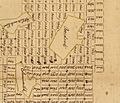
A detail from an old map from 1787, showing land lots near Accident.

See also
 In Spanish: Accident (Maryland) para niños
