Savage Mountain facts for kids
Quick facts for kids Savage Mountain |
|
|---|---|

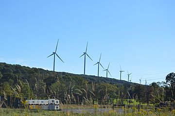
Wind farm on the summit, near Pleasant Union, Pennsylvania
|
|
| Highest point | |
| Peak | (High Point) |
| Elevation | 2,667 ft (813 m) |
| Dimensions | |
| Length | 30 mi (48 km) |
| Naming | |
| Etymology | eponym: John Savage |
| Geography | |
| Country | United States |
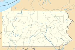
| Range coordinates | 39°53′11″N 78°44′10″W / 39.88639°N 78.73611°W |
| Parent range | Ridge-and-Valley Appalachians |
| Geology | |
| Orogeny | Alleghenian orogeny (the western edge of the Allegheny Formation "shows along the eastern slope of Savage Mountain".) |
| Type of rock | Carboniferous: "Mauch Chunk Red Shales and Limestones" |
Savage Mountain is a long ridge of land that stretches from Bedford County, Pennsylvania southwest into Western Maryland. It is like a big, upward fold in the Earth's rock layers, called an anticline. This mountain is part of the Ridge-and-Valley Appalachians. The eastern part of the ridge forms the border between Garrett and Allegany Counties in Maryland.
In Maryland, Savage Mountain actually has two main parts: Little Savage Mountain and Big Savage Mountain. Some parts of Savage Mountain are on the Eastern Continental Divide. This means that rain falling on one side flows towards the Ohio River, and rain falling on the other side flows towards the Potomac River. Water to the northwest of Savage Mountain drains into the Casselman River. The North Branch Potomac River watershed covers the southwestern and eastern parts of the ridge.
Contents
History of Savage Mountain
People have traveled through the Savage Mountain area for a very long time. Early paths like Nemacolin's Path and the first survey of the Potomac River (done between 1736 and 1737) went through here.
Early Roads and Surveys
The Braddock Road was opened over the ridge in 1757. This was an important road for travel and trade. By 1767, the famous Mason–Dixon line survey placed special markers, called milestones, across the ridge. Later, the National Road was finished through the area by 1818.
Tunnels and Trails
In 1911, construction began on two important tunnels: the Borden Tunnel and the Big Savage Tunnel. These tunnels were built for the Western Maryland Railway to help trains travel through the mountains. In the 1930s, the Civilian Conservation Corps (a group that helped people find work during the Great Depression) built a connecting road. This road is now a 6.4-mile trail called the Monroe Run Trail, which is great for hiking.
Water Control and Highways
The Savage River Dam and Reservoir were built in 1952. They are located just southwest of the ridge. Their main purpose is to control flooding along the Savage River and North Branch Potomac River. They also provide water to nearby towns.
On August 13, 1976, a new freeway opened through the ridge. This freeway later became Interstate 68. Because of thick fog that often happens along this part of the highway, Maryland installed its first "fog warning system" in 2003. This system was put in place after a serious crash in May 2003 that caused two deaths and injured about 100 people.
Forest Studies
In 2001, scientists studied the history of fires and the growth of oak trees on Savage Mountain. This helped them understand the forest better. Later, in 2007, about 2,600 new trees were planted in a special area called the Savage Mountain Demonstration Plot #2.
Wind Power on Savage Mountain
In 2006, a company called U.S. WindForce suggested building a wind farm on Savage Mountain. This wind farm would have 40 megawatts of power and would be built on a site where strip-mining used to happen. A study for a project to transmit this wind power, called the Savage Mountain Transmission Main Project, began in 2008.
Important Locations on Savage Mountain
| Point | Location | Elevation |
|---|---|---|
| CSX Transportation railroad | 39°48′30″N 78°57′27″W / 39.80833°N 78.95750°W | 2,430 feet (741 m) |
| Big Savage Mountain | 39°47′40″N 78°49′47″W / 39.79444°N 78.82972°W | 2,566 feet (782 m) |
| Big Savage Tunnel | 39°44′27″N 78°53′37″W / 39.74083°N 78.89361°W | 2,400 feet (732 m) (above tunnel) |
| Little Savage Mountain | 39°43′49″N 78°55′11″W / 39.73028°N 78.91972°W | 2,820 feet (860 m) |
| Maryland/Pennsylvania state line (Mason–Dixon line) | 39°43′21″N 78°54′51″W / 39.72250°N 78.91417°W | 2,840 feet (866 m) |
| U.S. Route 40 Alternate | 39°40′56″N 78°58′01″W / 39.68222°N 78.96694°W | 2,847 feet (868 m) |
| Interstate 68/U.S. Route 40 | 39°40′23″N 78°57′46″W / 39.67306°N 78.96278°W | 2,830 feet (863 m) |
| Elbow Mountain | 39°34′06″N 79°05′10″W / 39.56833°N 79.08611°W | 2,740 feet (835 m) |
 | William L. Dawson |
 | W. E. B. Du Bois |
 | Harry Belafonte |


