Nemacolin's Path facts for kids
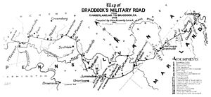
Nemacolin's Trail was an ancient Native American path. It crossed the big Allegheny Mountains through a Mountain pass called the Cumberland Narrows. This trail connected the Potomac River and the Monongahela River areas. Today, these are in the United States. Nemacolin's Trail linked what are now Cumberland, Maryland and Brownsville, Pennsylvania.
Contents
What Was Nemacolin's Trail?
This path was actually a network of trails. Native American people had used these trails for a very long time. This was even before European settlers arrived. Nemacolin's Path started near present-day Cumberland, Maryland. It then went on to Brownsville, Pennsylvania. The trail ended in a neighborhood now called Redstone. This area is at the mouth of Redstone Creek. Long ago, this spot was known as Redstone Old Fort. It had a defensive structure there.
Improving the Trail
In 1749 and 1750, an important project began. A Delaware Indian chief named Nemacolin worked with Maryland frontiersman Thomas Cresap. They were asked by Christopher Gist to improve the trail for the Ohio Company. They created the basic path that later became known as the eastern part of Braddock's Road.
Braddock's Road Connection
In 1755, during the French and Indian War, the English General Edward Braddock used this path. He used the eastern part of Nemacolin's Path as a military route. His goal was to capture Fort Duquesne, which the French held. This fort later became the city of Pittsburgh.
Crossing the Mountains
Crossing the Allegheny Mountains was a huge challenge. Even into the 1800s, it took a lot of planning, time, and hard work. East-west highways were not built across the border between Virginia and West Virginia until much later. These two regions were separated by some of the toughest mountain terrain.
Without using the Cumberland Narrows, travelers would have to go hundreds of miles. They would need to travel far north or south to get through the mountains. This is because the ridgelines run north-south and are almost impossible to cross.
The Trail's Legacy
Nemacolin's Trail was improved many times over the years. It became the Cumberland Road, then the National Road, and also the National Pike. Eventually, it became U.S. Route 40, or the National Highway. U.S. Route 40 was one of the first official highways in the United States.
The earlier road, known as the Cumberland Road/National Road, used a special bridge. It ran on the Dunlap's Creek Bridge, which was the first cast iron bridge built in the United States. Nemacolin's Trail became a very important route. It was the main way settlers in Conestoga wagons or stage coaches reached the lands west of the Appalachian mountains.
 | Jewel Prestage |
 | Ella Baker |
 | Fannie Lou Hamer |


