
Cumberland, Maryland facts for kids
Quick facts for kids
Cumberland, Maryland
|
|||
|---|---|---|---|

Downtown Cumberland
|
|||
|
|||
| Nicknames:
"Queen City"
|
|||
| Motto(s):
"Come for a Visit, Stay for Life!"
|
|||

Location in Allegany County and in Maryland
|
|||

Cumberland, Maryland
Location in Maryland

Cumberland, Maryland
Location in the United States
|
|||
| Country | |||
| State | |||
| County | |||
| Founded | 1787 | ||
| Incorporated | January 23, 1815 | ||
| Government | |||
| • Type | Council-CEO | ||
| Area | |||
| • Total | 10.12 sq mi (26.22 km2) | ||
| • Land | 10.06 sq mi (26.04 km2) | ||
| • Water | 0.07 sq mi (0.18 km2) | ||
| Elevation | 640 ft (200 m) | ||
| Population
(2020)
|
|||
| • Total | 19,076 | ||
| • Density | 1,897/sq mi (732/km2) | ||
| • Demonym | Cumberlander | ||
| Time zone | UTC−5 (Eastern (EST)) | ||
| • Summer (DST) | UTC−4 (EDT) | ||
| ZIP Codes |
21501–21505
|
||
| Area code(s) | 301, 240 | ||
| FIPS code | 24-21325 | ||
| GNIS feature ID | 2390580 | ||


Cumberland is a city in Allegany County, Maryland, United States. It's the main city of the county. In 2020, about 19,075 people lived there. Cumberland is located on the Potomac River and is a major business and shopping area for Western Maryland and nearby West Virginia. It's the main city of the Cumberland metropolitan area, which had about 95,044 residents in 2020.
Historically, Cumberland was called the "Queen City" because it was once the second-largest city in Maryland. It was an important stopping point for people traveling west through the Appalachian Mountains in the early 1800s. This helped people settle in new lands like the Ohio Country. Cumberland also became an industrial center, connected by major roads, railroads, and the Chesapeake and Ohio Canal. Today, Interstate 68 runs through the city.
After World War II, many industries in Cumberland closed. This caused the city's population to shrink.
Contents
History of Cumberland
Cumberland got its name from Prince William, the Duke of Cumberland, who was the son of King George II. The city was built where Fort Cumberland once stood in the mid-1700s. This fort was a starting point for British General Edward Braddock during the French and Indian War. This war was a big fight between the French and British in North America.
Colonel George Washington also used Fort Cumberland as an outpost during the French and Indian War. His first military headquarters was built here. Later, as President, Washington returned to Cumberland in 1794. He came to check on troops who were stopping the Whiskey Rebellion.
During the 1800s, Cumberland became a very important place for roads, railroads, and canals. It grew to be the second-largest city in Maryland, after Baltimore. This is why it was nicknamed "The Queen City." Cumberland was the end point of the Cumberland Road, which started in 1811 and went west to the Ohio River. This road later became part of the National Road, reaching states like Ohio and Illinois.
In the 1850s, many enslaved people seeking freedom found help in Cumberland. They used a network of tunnels under the Emmanuel Episcopal Church as a stop on the Underground Railroad. An abolitionist pastor helped them before they made the final trip to freedom in Pennsylvania.
The hills around Cumberland had coal and iron ore, and lots of timber. These resources helped fuel the Industrial Revolution. The Chesapeake and Ohio Canal also ended here. It was built to move goods between the Midwest and Washington, D.C. However, railroads became more popular because they were faster and could carry more goods. Cumberland grew into a big manufacturing center, making things like glass, beer, fabrics, tires, and tinplate.
After World War II, many large factories in the area closed down. This caused Cumberland to lose many jobs. As a result, the city's population has dropped by almost half since 1940.
Geography of Cumberland
Cumberland is located in the Ridge-and-Valley Appalachians where the North Branch Potomac River and Wills Creek meet. Most of the city is in a valley formed by these two waterways. Interstate 68 runs through the city from east to west. Alternate U.S. 40, also known as the Old National Road, also passes through. U.S. Highway 220 runs north and south. Parts of Wills Mountain, Haystack Mountain, and Shriver Ridge are also within the city limits. Across the Potomac River from Cumberland is Ridgeley, West Virginia.
The old Chesapeake and Ohio Canal is now part of the Chesapeake and Ohio Canal National Historical Park. You can walk, ride a horse, or bike on the canal's towpath for about 185 miles (298 km) between Cumberland and Washington, D.C.. A newer trail, called the Great Allegheny Passage, connects Cumberland to Pittsburgh. This combined trail is over 300 miles long!
The city covers about 10.15 square miles (26.29 km2) of land and a small amount of water.
Cumberland's Climate
Cumberland has four clear seasons. Summers are hot and humid, while winters are moderate with less snow compared to nearby areas. Temperatures in July average around 75.8 °F (24.3 °C), and in January, they average about 30.8 °F (−0.7 °C). It can get hotter than 90 °F (32 °C) on about 34 days a year, and colder than 10 °F (−12 °C) on about 7 nights each winter. The average snowfall is about 28.7 inches (73 cm) per year.
| Climate data for Cumberland 2, Maryland (1991−2020 normals, extremes 1974−present) | |||||||||||||
|---|---|---|---|---|---|---|---|---|---|---|---|---|---|
| Month | Jan | Feb | Mar | Apr | May | Jun | Jul | Aug | Sep | Oct | Nov | Dec | Year |
| Record high °F (°C) | 75 (24) |
83 (28) |
90 (32) |
96 (36) |
98 (37) |
103 (39) |
105 (41) |
105 (41) |
102 (39) |
94 (34) |
87 (31) |
80 (27) |
105 (41) |
| Mean daily maximum °F (°C) | 39.2 (4.0) |
43.4 (6.3) |
53.0 (11.7) |
66.3 (19.1) |
74.6 (23.7) |
82.5 (28.1) |
87.1 (30.6) |
85.4 (29.7) |
78.5 (25.8) |
66.8 (19.3) |
53.9 (12.2) |
42.9 (6.1) |
64.5 (18.1) |
| Daily mean °F (°C) | 30.8 (−0.7) |
33.7 (0.9) |
42.1 (5.6) |
53.6 (12.0) |
62.9 (17.2) |
71.3 (21.8) |
75.8 (24.3) |
74.0 (23.3) |
66.8 (19.3) |
55.0 (12.8) |
43.7 (6.5) |
35.0 (1.7) |
53.7 (12.1) |
| Mean daily minimum °F (°C) | 22.5 (−5.3) |
23.9 (−4.5) |
31.2 (−0.4) |
40.9 (4.9) |
51.2 (10.7) |
60.1 (15.6) |
64.4 (18.0) |
62.7 (17.1) |
55.0 (12.8) |
43.2 (6.2) |
33.5 (0.8) |
27.1 (−2.7) |
43.0 (6.1) |
| Record low °F (°C) | −14 (−26) |
−3 (−19) |
3 (−16) |
20 (−7) |
25 (−4) |
39 (4) |
46 (8) |
38 (3) |
31 (−1) |
20 (−7) |
10 (−12) |
−8 (−22) |
−14 (−26) |
| Average precipitation inches (mm) | 2.79 (71) |
2.38 (60) |
3.42 (87) |
3.41 (87) |
4.22 (107) |
3.87 (98) |
3.73 (95) |
3.40 (86) |
3.55 (90) |
2.82 (72) |
2.58 (66) |
3.05 (77) |
39.22 (996) |
| Average snowfall inches (cm) | 8.2 (21) |
7.7 (20) |
6.8 (17) |
0.1 (0.25) |
0.0 (0.0) |
0.0 (0.0) |
0.0 (0.0) |
0.0 (0.0) |
0.0 (0.0) |
0.0 (0.0) |
0.5 (1.3) |
5.4 (14) |
28.7 (73) |
| Average precipitation days (≥ 0.01 in) | 12.6 | 10.9 | 12.1 | 12.6 | 14.4 | 12.4 | 10.9 | 10.7 | 10.0 | 9.4 | 9.1 | 11.3 | 136.4 |
| Average snowy days (≥ 0.1 in) | 3.5 | 3.4 | 2.1 | 0.1 | 0.0 | 0.0 | 0.0 | 0.0 | 0.0 | 0.0 | 0.3 | 2.1 | 11.5 |
| Source: NOAA | |||||||||||||
People of Cumberland
| Historical population | |||
|---|---|---|---|
| Census | Pop. | %± | |
| 1840 | 2,428 | — | |
| 1850 | 6,073 | 150.1% | |
| 1860 | 4,078 | −32.9% | |
| 1870 | 8,056 | 97.5% | |
| 1880 | 10,693 | 32.7% | |
| 1890 | 12,729 | 19.0% | |
| 1900 | 17,128 | 34.6% | |
| 1910 | 21,839 | 27.5% | |
| 1920 | 29,837 | 36.6% | |
| 1930 | 37,747 | 26.5% | |
| 1940 | 39,483 | 4.6% | |
| 1950 | 37,679 | −4.6% | |
| 1960 | 33,415 | −11.3% | |
| 1970 | 29,724 | −11.0% | |
| 1980 | 25,933 | −12.8% | |
| 1990 | 23,706 | −8.6% | |
| 2000 | 21,518 | −9.2% | |
| 2010 | 20,859 | −3.1% | |
| 2020 | 19,076 | −8.5% | |
| 2022 (est.) | 18,769 | −10.0% | |
| U.S. Decennial Census | |||

In 2010, there were 20,859 people living in Cumberland. About 25.9% of homes had children under 18. The average age in the city was 41.4 years. About 20.9% of residents were under 18, and 19.6% were 65 or older.
The population of Cumberland has been decreasing since 1950. This happened because many factories closed down after World War II. The closing of the Kelly Springfield Tire Plant in 1987 was a big moment, as it was the last major factory in the city to shut down.
Cumberland's Economy
Cumberland has several important employers. Here are some of the top ones:
| Employer | Employees (2021) |
|---|---|
| Western Maryland Regional Medical | 2,200 |
| Frostburg State University | 1,005 |
| CSX Transportation | 635 |
| Western Correctional Institution | 588 |
| North Branch Correctional Institution | 574 |
| WebstaurantStore | 438 |
| Conduent | 380 |
| Rocky Gap Casino Resort | 337 |
| ASPIRA Association | 325 |
Arts and Culture in Cumberland

Fun Places to Visit
Western Maryland Railway Station
At the Western Maryland Railway Station, you can find the Western Maryland Scenic Railroad. This train takes you on fun trips through the area.
Arts and Entertainment District
Cumberland has a special arts and entertainment district. Here you can find places like the Saville Gallery, the Allegany Museum, and the Cumberland Theatre. There are also art galleries, music academies, and unique shops. You can enjoy events like the Cumberland Comes Alive music series and Saturday Arts Walks.
Canal Place Heritage Area

The Chesapeake and Ohio Canal National Historical Park starts at Canal Place. This is where the canal, railroad, and the Allegheny Highlands Trail of Maryland all meet. It's a great spot to explore history and nature.
Allegany Museum

The Allegany Museum has many exhibits about local history. You can learn about prehistoric life, the glass industry, and the history of brewing in Cumberland. They also have folk art on display.
The Narrows and Lovers Leap
The Narrows is a narrow valley that Wills Creek has carved into Wills Mountain. The National Road (U.S. Route 40) and train tracks pass through this rocky valley.
On the side of Wills Mountain, there's a rocky spot called Lover's Leap. It's named after an old Native American legend about a jilted lover. From the top, you can see amazing views of the Allegheny Mountains, the city of Cumberland, and parts of Pennsylvania and West Virginia. Lover's Leap is about 1,652 feet (504 m) above sea level.
Other Fun Spots
- Constitution Park
- Cumberland Theatre Company, which puts on plays all year.
- Gene Mason Sports Complex
- New Embassy Theater
Nearby Places to Explore
- The Thrasher Carriage Museum in Frostburg, Maryland, has a large collection of old horse-drawn vehicles. You can see everything from milk carts to fancy carriages.
- The Paw Paw Tunnel is one of the longest canal tunnels in the world. It was an amazing engineering achievement when it was built.
- The Sideling Hill road cut is a 340-foot (100 m) deep cut where Interstate 68 goes through Sideling Hill. It's a cool place to see different layers of rock.
- Dan's Mountain State Park
Famous Buildings and Landmarks


Many beautiful and important homes are in the Washington Street Historic District. This area was where the city's most important people lived when Cumberland was doing very well. Important public buildings include the Allegany County Courthouse and the Emmanuel Episcopal Church.
The 1850 Emmanuel Episcopal Church is a great example of early Gothic Revival architecture. It has three large Tiffany windows and tunnels from the old Fort Cumberland underneath. The Allegany County Courthouse stands out in the city's skyline. It was designed in 1893. The Queen City Hotel was a grand hotel built in the 1870s, but it was torn down in 1972. Temple B'er Chayim's building from 1865 is one of the oldest synagogue buildings still standing in the United States.
Other notable places include the Western Maryland Scenic Railroad, the Chesapeake and Ohio Canal National Historical Park, the Allegheny Highlands Trail of Maryland, and Rocky Gap State Park.
Education in Cumberland
In 1864, money was set aside to help fund schools for African Americans. The first public school for African Americans in Cumberland was called the Mary Hoye school. In 1923, a new school for Black students was built and later renamed George Washington Carver School. Many Black students from nearby West Virginia also came to Carver because their local schools were not as good. Schools in Cumberland became integrated in 1955.
The main offices for Allegany County Public Schools are in Cumberland. There are two public high schools in the city for grades 9-12: Allegany High School and Fort Hill High School. These high schools are fed by two middle schools, Braddock Middle School and Washington Middle School, for grades 6-8. Public elementary schools in Cumberland include John Humbird Elementary, South Penn Elementary, and West Side Elementary.
Cumberland also has two private schools. Bishop Walsh School is a Catholic school for grades K-12. Lighthouse Christian Academy is a Christian school for grades K-12.
Many people in Allegany County have library cards. Libraries include the Washington Street Library and the Lavale Public Library.
Media in Cumberland
Cumberland has several local media options. The Cumberland Times-News is the daily newspaper for the area.
Cumberland's Infrastructure
Utilities
The City of Cumberland provides water and sewer services. The water comes from two lakes, Gordon and Koon. Electricity is supplied by the Potomac Edison Company, and natural gas by Columbia Gas of Maryland. Hospitals in the area include UPMC Western Maryland.
Transportation
Air Travel
The Greater Cumberland Regional Airport (CBE) provides local air transportation. It's located in Wiley Ford, West Virginia, just south of the Potomac River.
Roads and Highways
_at_its_interchange_with_U.S._Route_220_from_the_overpass_for_Fletcher_Drive_in_Cumberland,_Allegany_County,_Maryland.jpg)
Several main highways serve Cumberland. The most important is Interstate 68, which runs with U.S. Route 40 through the city. Eastward, I-68 and US 40 connect to Interstate 70. Westward, I-68 goes to Morgantown, West Virginia, and US 40 goes into southern Pennsylvania.
U.S. Route 220 also passes through Cumberland. To the north, US 220 heads towards Bedford, Pennsylvania, and to the south, it reaches Keyser.
Other important roads include U.S. Route 40 Alternate and several Maryland Route roads.
Public Transport
Allegany County Transit provides bus service in Cumberland. This service covers most areas of the city. Amtrak, the national passenger train system, offers train service to Cumberland. The Capitol Limited train runs between Washington, D.C., and Chicago. The Cumberland Amtrak Station is downtown. The Western Maryland Scenic Railroad runs fun steam and diesel train trips from Cumberland to Frostburg and back.
Famous People from Cumberland
Sister Cities
Images for kids
-
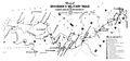
Map of Braddock's Military Road
-
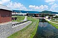
Terminus of the Chesapeake and Ohio Canal in Cumberland. Highway bridge is Interstate 68. Canal Place Museum is the brick building behind bridge.


See also
 In Spanish: Cumberland (Maryland) para niños
