Ridgeley, West Virginia facts for kids
Quick facts for kids
Ridgeley, West Virginia
|
||
|---|---|---|

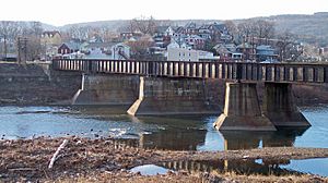
Ridgeley and the North Branch of the Potomac River, as viewed from Cumberland, Maryland, in 2007
|
||
|
||

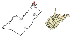
Location of Ridgeley in Mineral County, West Virginia.
|
||
| Country | United States | |
| State | West Virginia | |
| County | Mineral | |
| Government | ||
| • Type | Mayor/council | |
| Area | ||
| • Total | 0.30 sq mi (0.78 km2) | |
| • Land | 0.29 sq mi (0.75 km2) | |
| • Water | 0.01 sq mi (0.02 km2) | |
| Elevation | 689 ft (210 m) | |
| Population
(2020)
|
||
| • Total | 590 | |
| • Estimate
(2021)
|
584 | |
| • Density | 2,137.93/sq mi (824.66/km2) | |
| Time zone | UTC-5 (Eastern (EST)) | |
| • Summer (DST) | UTC-4 (EDT) | |
| ZIP code |
26753
|
|
| Area code(s) | 304 | |
| FIPS code | 54-68260 | |
| GNIS feature ID | 2391388 | |
Ridgeley is a town located in Mineral County, West Virginia, in the United States. It is part of the larger Cumberland area. In 2020, about 590 people lived here.
Ridgeley was first called St. Clairsville. It got its name from Sir John St Clair, a British military officer. The town was officially formed and named Ridgeley on November 28, 1914. It was named after the people who used to own the land where the town now stands.
Contents
Exploring Ridgeley's Location
Ridgeley is found along the North Branch of the Potomac River. It sits right across the river from Cumberland, Maryland.
The United States Census Bureau says the town covers about 0.30 square miles (0.78 square kilometers). Most of this area is land, with a small part being water.
Getting Around Ridgeley
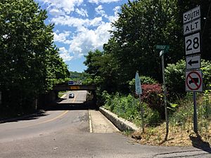
The main road in Ridgeley is West Virginia Route 28 Alternate. This road goes south to connect with West Virginia Route 28, which leads to Romney. If you head north on WV 28 Alt, you can cross the Blue Bridge into Cumberland, Maryland. Bigger highways like Interstate 68, U.S. Route 40, and U.S. Route 220 are all found in Cumberland.
Ridgeley's Unique Rocks
The town of Ridgeley is known for a special type of rock called the Ridgeley Member of the Old Port Formation. This name was given to local sandstone because Ridgeley, West Virginia, is at the eastern edge of where this rock formation is found. This sandstone is often dug up and used from local quarries.
Who Lives in Ridgeley?
| Historical population | |||
|---|---|---|---|
| Census | Pop. | %± | |
| 1920 | 1,709 | — | |
| 1930 | 1,972 | 15.4% | |
| 1940 | 1,907 | −3.3% | |
| 1950 | 1,754 | −8.0% | |
| 1960 | 1,229 | −29.9% | |
| 1970 | 1,112 | −9.5% | |
| 1980 | 994 | −10.6% | |
| 1990 | 779 | −21.6% | |
| 2000 | 762 | −2.2% | |
| 2010 | 675 | −11.4% | |
| 2020 | 590 | −12.6% | |
| 2021 (est.) | 584 | −13.5% | |
| U.S. Decennial Census | |||
Ridgeley's Population in 2010
In 2010, there were 675 people living in Ridgeley. These people lived in 301 households, with 180 of them being families. The town had about 2,328 people per square mile.
Most of the people in Ridgeley were White (92.4%). There were also smaller groups of African American, Native American, and Asian residents. About 2.5% of the population identified as being from two or more races.
About 26% of households had children under 18. Many households (43.5%) were married couples. The average household had 2.24 people, and the average family had 2.86 people. The average age in Ridgeley was 40.8 years old.
Learning in Ridgeley
Ridgeley is part of the Mineral County Schools district. Students in grades 9-12 attend Frankfort High School, which is located near Short Gap.
Ridgeley's Past: A Look Back
The land where Ridgeley stands was first given to George Mason in 1749. In 1750, the very first fort on the frontier, Fort Ohio, was built here. It was known as the "New Store" settlement and was the westernmost outpost of colonial life.
The New Store was a trading post created by the Ohio Company. Important people like George Mason and Lawrence Washington were part of this company. Christopher Gist oversaw the building of the "New Store," which was close to where the Blue Bridge is today. From 1750 to 1763, it was a base for traders and trappers. It also served as a fort to protect travelers and workers from Native American attacks. At that time, there were no white settlers in the area. It was truly on the "outskirts of civilization."
In May 1754, George Washington came to Fort Ohio with his troops. He was supposed to meet Colonel Joshua Fry, who was to lead the forces on the frontier. Sadly, Fry died after falling from his horse on the way to the fort. Washington then took command, which was his first military leadership role.
Washington led an attack from Fort Ohio against a group of French soldiers. This fight led to the death of a French diplomat, Ensign Joseph Coulon de Jumonville. This event is seen as the first shot fired in the French and Indian War.
In 1755, Washington returned to the area to help prepare for General Edward Braddock's attack on Fort Duquesne. This event is often called Braddock's March. Both Fort Cumberland and Fort Ohio were used for planning this attack. A young Daniel Boone and Daniel Morgan also worked in the area during this time.
After Fort Cumberland was mostly left empty in 1763, the Ohio Company sold the land. Over time, the land was passed down through different owners. In 1803, Captain George Calmes bought the land and built a large house there. Later in the 1800s, parts of the town began to be divided up for homes and businesses. From 1905 to 1919, the Calmes Mansion was leased and became the Potomac Club, a popular tennis and boating club.
In 1887, the West Virginia Central and Pittsburg Railway built train yards and tracks in Ridgeley. In 1904, this railway became the Western Maryland Railroad. Ridgeley grew into a community where many people worked for the railroad. For a long time, the town was called "St. Clairsville" or "Sinclairsville." But when it officially became a town in 1914, it was renamed Ridgeley after Charles Ridgeley, an important early resident and businessman.
Ridgeley continued to grow in the early 1900s, becoming a busy community with schools, churches, and businesses. Flooding from the Potomac River was a big problem until the Army Corps of Engineers finished a large flood control project in the 1950s. Later, in the 1970s and 1980s, all the schools in Ridgeley closed as the Mineral County Schools system combined schools in the area.
Famous People from Ridgeley
- John Lookabaugh (1922–1993), an American football player.
- Grant Noel (born 1980), another American football player.
- William E. Shuck Jr. (1926–1952), a United States Marine.
See also
 In Spanish: Ridgeley (Virginia Occidental) para niños
 | Percy Lavon Julian |
 | Katherine Johnson |
 | George Washington Carver |
 | Annie Easley |


