
Old Port Formation facts for kids
Quick facts for kids Old Port FormationStratigraphic range: Early Devonian |
|
|---|---|

Ridgeley Member of the Old Port Formation
|
|
| Type | sedimentary |
| Unit of | Helderberg Group |
| Sub-units | Ridgeley, Shriver, Mandata, Corriganville, and New Creek Members |
| Underlies | Onondaga Formation |
| Overlies | Keyser Formation |
| Thickness | 150 to 190 ft (Mifflintown Quadrangle in PA) |
| Lithology | |
| Primary | limestone, sandstone |
| Other | chert, shale |
| Location | |
| Region | Appalachian Mountains |
| Extent | Pennsylvania, Maryland, Virginia, West Virginia |
| Type section | |
| Named by | Conlin and Hoskins, 1962 |
The Old Port Formation is a type of rock layer found in Pennsylvania, USA. It formed a long, long time ago during the early Devonian Period. Geologists (scientists who study rocks) use this name mainly for rocks in Pennsylvania. However, similar rock layers can be found in nearby states too.
Contents
What is the Old Port Formation?
The Old Port Formation is made up of different kinds of rocks. These include limestone, sandstone, shale, and chert.
Layers of the Old Port Formation
The Old Port Formation is like a big sandwich of different rock layers. Each layer is called a "member." These members are stacked on top of each other. From oldest (bottom) to youngest (top), they are:
- New Creek Member (mostly limestone)
- Corriganville Member (mostly limestone)
- Mandata Member (mostly shale)
- Shriver Member (limestone with lots of chert)
- Ridgeley Member (mostly sandstone)
Sometimes, a rock layer called the Licking Creek Limestone can take the place of the Shriver Chert. Scientists named this whole formation in 1962.
Ridgeley Member: The Glass Maker
The Ridgeley Member is a special part of the Old Port Formation. It was first described in 1913. It's mostly a sandy rock that can sometimes turn into a sandy limestone. You can find it in places like Ridgeley, West Virginia.
This sandstone is very pure. It has a lot of quartz, which is great for making glass. In fact, the glass from this sandstone was even used to make lenses for the Hubble Space Telescope!
Shriver Member: Chert and Shale
The Shriver Member is made of dark, sandy shale with lots of black, lumpy chert. Chert is a hard, glass-like rock. This member was also first described in 1913. It's named after Shriver Ridge in Allegany County, Maryland.
You can find the Shriver Member in different rock groups depending on where you are. In Maryland and West Virginia, it's part of the Helderberg Group. In central Pennsylvania, it's part of the Old Port Formation.
Mandata Member: The Shale Layer
The Mandata Member is a layer of shale. It was named in 1938 after a place called Mandata, Pennsylvania. You can see where it was first studied near Route 225 in Mandata.
Corriganville Member: Gray Limestone
The Corriganville Member is a gray limestone that often contains chert. It was first described in 1972 in Allegany County, Maryland. Scientists later mapped it as part of the Old Port Formation in Pennsylvania. Its original study site is near Corriganville, Maryland.
New Creek Member: Another Limestone Layer
The New Creek Member is a thick layer of limestone. It sits on top of another rock layer called the Keyser Formation. This member was also mapped as part of the Old Port Formation in Pennsylvania.
Licking Creek Member: Chert and Limestone
The Licking Creek Limestone was first described in 1938. It's made of layers and lumps of black chert mixed with light-gray limestone. You can find where it was first studied near Licking Creek (Potomac River) in Franklin County, Pennsylvania.
Where Can You See These Rocks?
You can see parts of the Old Port Formation in several places:
- An old quarry in Tyrone, Pennsylvania, near Sink Run and U.S. Route 22.
- Two spots in Everett, Pennsylvania:
- A road cut along U.S. Route 30 in Pennsylvania (Everett Bypass).
- Another spot along Business Route 30 on the west side of Everett.
- The Sinnett-Thorn Mountain Cave System is formed in the New Creek and Corriganville Limestone Members.
Fossils Found in the Old Port Formation
Scientists have found some cool fossils in the Old Port Formation!
- In the Ridgeley Member, you can sometimes find many brachiopods. Brachiopods are small sea creatures with two shells, a bit like clams.
- The Shriver Member also has brachiopods like Costispirifer arenosus and Chonetes hudsonicus. Tiny creatures called ostracods (which are like small crustaceans) have also been found here.
- The Old Port Formation also contains conodonts, which are tiny, tooth-like fossils from ancient eel-like creatures.
How Old is the Old Port Formation?
Scientists use different methods to figure out the age of rocks. The Old Port Formation formed during the early Devonian Period. It usually sits directly on top of the Keyser Formation. It is typically found below the Needmore Formation or the Onondaga Formation.
Why is the Old Port Formation Important?
The Ridgeley Member of the Old Port Formation is important because it is mined a lot in Pennsylvania and Maryland. As mentioned, its pure quartz sandstone is valuable for making glass and other products.
Images for kids
-
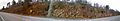
A panorama of a roadcut through the Ridgeley Member along U.S. Route 522 north of Shirleysburg, Pennsylvania, April 2011
-
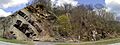
A panorama of outcrop of Keyser Formation (left) and Corriganville and New Creek Members in Everett, Pennsylvania along Business Route 30 (West Main Street), facing north, April 2011
