Shirleysburg, Pennsylvania facts for kids
Quick facts for kids
Shirleysburg, Pennsylvania
|
|
|---|---|
|
Borough
|
|

|
|

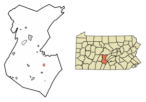
Location of Shirleysburg in Huntingdon County, Pennsylvania.
|
|
| Country | United States |
| State | Pennsylvania |
| County | Huntingdon |
| Government | |
| • Type | Borough Council |
| Area | |
| • Total | 0.16 sq mi (0.41 km2) |
| • Land | 0.16 sq mi (0.41 km2) |
| • Water | 0.00 sq mi (0.00 km2) |
| Elevation | 584 ft (178 m) |
| Population
(2010)
|
|
| • Total | 150 |
| • Estimate
(2019)
|
139 |
| • Density | 868.75/sq mi (335.98/km2) |
| Time zone | UTC-5 (Eastern (EST)) |
| • Summer (DST) | UTC-4 (EDT) |
| ZIP code |
17260
|
| Area code(s) | 814 |
| FIPS code | 42-70408 |
| GNIS feature ID | 1215280 |
| Local phone exchanges: 447, 448 | |
Shirleysburg is a small town, also called a borough, located in Huntingdon County, Pennsylvania, in the United States. In 2010, about 150 people lived there. It's a place with a lot of history, especially from the time of early American conflicts.
Contents
Discover Shirleysburg's Past
Shirleysburg gets its name from Fort Shirley. This fort was an important place during the French and Indian War. This war was a big conflict between Great Britain and France, with their Native American allies, in North America.
Fort Shirley: A Frontier Outpost
In 1754, a Native American chief named Monacatoocha (also known as Scarouady) led about 200 Native Americans to a trading post. These groups included the Oneida, Lenape, and Shawnee people. They were seeking safety at a trading post owned by George Croghan. Croghan then built a strong, fenced-in building called "Croghan's Fort."
After a major defeat of British forces in 1755, the governor ordered the fort to be renamed Fort Shirley. Several other forts were built nearby. These forts created a defensive line to protect settlers from attacks. However, Fort Shirley was later left empty in 1756. It was thought to be too hard to defend.
Becoming a Borough and the Railroad's Arrival
Shirleysburg officially became a borough on April 3, 1837. By 1840, its population had grown to 247 people.
A special kind of train track, called a narrow gauge railroad, was built through Shirleysburg in 1873. This was part of the East Broad Top Railroad (EBT). The railroad served the town for 83 years, stopping operations in 1956.
Since 1960, the EBT has run tourist trains. These trains travel from Rockhill to Colgate Grove, just south of Shirleysburg. The old, unused tracks still pass through the town on their way to Mount Union.
Historic Buildings in Shirleysburg
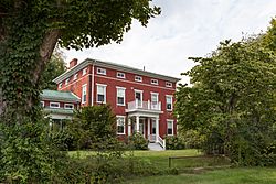
The Benjamin B. Leas House is a very old and important building in Shirleysburg. It was added to the National Register of Historic Places in 1984. This means it is recognized for its historical value.
Exploring Shirleysburg's Geography
Shirleysburg is located in the southeastern part of Huntingdon County. It sits in a valley near Aughwick Creek. To the east, you can see Blacklog Mountain, and to the west is Jacks Mountain.
Roads and Waterways
U.S. Route 522 is a main road that goes right through Shirleysburg. If you drive north on this road, you'll reach Mount Union in about 6 miles. If you drive south, you'll get to Orbisonia, near Rockhill, in about 4 miles.
The borough covers a total area of about 0.4 square kilometers (0.16 square miles). All of this area is land. The western edge of Shirleysburg follows Aughwick Creek. This creek flows north and eventually joins the Juniata River.
Shirleysburg's Population Over Time
| Historical population | |||
|---|---|---|---|
| Census | Pop. | %± | |
| 1840 | 247 | — | |
| 1850 | 361 | 46.2% | |
| 1860 | 354 | −1.9% | |
| 1870 | 320 | −9.6% | |
| 1880 | 367 | 14.7% | |
| 1890 | 325 | −11.4% | |
| 1900 | 230 | −29.2% | |
| 1910 | 256 | 11.3% | |
| 1920 | 200 | −21.9% | |
| 1930 | 217 | 8.5% | |
| 1940 | 242 | 11.5% | |
| 1950 | 241 | −0.4% | |
| 1960 | 170 | −29.5% | |
| 1970 | 238 | 40.0% | |
| 1980 | 147 | −38.2% | |
| 1990 | 140 | −4.8% | |
| 2000 | 140 | 0.0% | |
| 2010 | 150 | 7.1% | |
| 2019 (est.) | 139 | −7.3% | |
| Sources: | |||
According to the census from 2000, there were 140 people living in Shirleysburg. These people lived in 61 households. The population density was about 878.5 people per square mile.
Who Lives in Shirleysburg?
The population in 2000 included people of different ages. About 25.7% of the residents were under 18 years old. About 16.4% were 65 years old or older. The average age of people in Shirleysburg was 42 years. For every 100 females, there were 100 males.
See also
 In Spanish: Shirleysburg para niños
 | Madam C. J. Walker |
 | Janet Emerson Bashen |
 | Annie Turnbo Malone |
 | Maggie L. Walker |


