
Romney, West Virginia facts for kids
Quick facts for kids
Romney, West Virginia
|
|
|---|---|

National Building in downtown Romney
|
|
| Motto(s):
"First in West Virginia – Est. 1762"
|
|

Location of Romney in Hampshire County, West Virginia
|
|

Romney, West Virginia
Location in Romney, West Virginia

Romney, West Virginia
Location in Eastern Panhandle of West Virginia

Romney, West Virginia
Location in West Virginia

Romney, West Virginia
Location in the United States
|
|
| Country | United States |
| State | West Virginia |
| County | Hampshire |
| Incorporation | December 23, 1762 |
| Government | |
| • Type | Mayor–council |
| • Body | Romney Town Council |
| Area | |
| • Total | 0.96 sq mi (2.49 km2) |
| • Land | 0.96 sq mi (2.49 km2) |
| • Water | 0.00 sq mi (0.00 km2) |
| Elevation | 804 ft (245 m) |
| Population
(2020)
|
|
| • Total | 1,722 |
| • Estimate
(2021)
|
1,717 |
| • Density | 1,763.79/sq mi (681.32/km2) |
| Time zone | UTC-5 (EST) |
| • Summer (DST) | UTC-4 (EDT) |
| ZIP code |
26757
|
| Area code(s) | 304 |
| FIPS code | 54-70084 |
| GNIS feature ID | 2390646 |
Romney is a town in West Virginia, United States. It is the main town and county seat of Hampshire County, West Virginia. In 2020, about 1,722 people lived there.
Romney is part of the larger Winchester, Virginia metropolitan area. It was founded in 1762. Along with Shepherdstown, Romney is one of the two oldest towns in West Virginia.
Contents
History of Romney
Romney was officially created by the government on December 23, 1762. This happened through special laws passed by the Virginia House of Burgesses. At the same time, another town called Mecklenburg (now Shepherdstown) was also established. This makes Romney and Shepherdstown the two oldest towns in West Virginia.
Early Settlement and Naming
Romney was first settled in 1725 by hunters and traders. Back then, it was known as Pearsall's Flats. During the French and Indian War, a fort called Fort Pearsall was built here.
The town was named "Romney" by Thomas Fairfax, 6th Lord Fairfax of Cameron. He named it after the town of Romney in Kent, England. You can still find names in Romney today that connect to its colonial past. For example, Marsham Street is named after Robert Marsham, a famous person from that time.
Romney is also home to the West Virginia Schools for the Deaf and Blind. It also has the nation's First Confederate Memorial, located in Indian Mound Cemetery.
Education in Early Romney
The Romney Academy was started in 1814. It was one of the first places for higher education in what is now West Virginia. The academy later became the Romney Classical Institute in 1846. This institute taught both boys and girls to prepare them for college. However, it closed in 1866 because many students left to fight in the American Civil War.
Romney During the Civil War
Romney played a role in the early American Civil War. The Romney Expedition was a military movement by the Confederate States Army. It was part of Stonewall Jackson's plan to clear Union Army troops from the Shenandoah Valley.
Jackson's army moved towards Cumberland, Maryland. But they had to turn back from Romney because of very bad winter weather. During the war, both Union and Confederate soldiers occupied Romney many times.
West Virginia Schools for the Deaf and Blind
The West Virginia Schools for the Deaf and the Blind was founded in 1870. It was built on the same land where the Romney Classical Institute used to be.
Geography and Climate
Romney covers an area of about 0.96 square miles (2.49 square kilometers). All of this area is land.
What is Romney's Climate Like?
Romney has a climate with hot, humid summers. The winters are generally cold. This type of weather is called a humid continental climate. You can find detailed weather information for Romney in the table below.
| Climate data for Romney, West Virginia (1991–2020 normals, extremes 1891–present) | |||||||||||||
|---|---|---|---|---|---|---|---|---|---|---|---|---|---|
| Month | Jan | Feb | Mar | Apr | May | Jun | Jul | Aug | Sep | Oct | Nov | Dec | Year |
| Record high °F (°C) | 79 (26) |
85 (29) |
94 (34) |
101 (38) |
101 (38) |
104 (40) |
107 (42) |
109 (43) |
104 (40) |
98 (37) |
85 (29) |
80 (27) |
109 (43) |
| Mean daily maximum °F (°C) | 40.2 (4.6) |
44.2 (6.8) |
53.1 (11.7) |
66.1 (18.9) |
74.6 (23.7) |
82.2 (27.9) |
86.3 (30.2) |
84.8 (29.3) |
78.4 (25.8) |
67.0 (19.4) |
54.7 (12.6) |
43.9 (6.6) |
64.6 (18.1) |
| Daily mean °F (°C) | 30.5 (−0.8) |
33.6 (0.9) |
41.2 (5.1) |
52.2 (11.2) |
61.6 (16.4) |
69.7 (20.9) |
73.2 (22.9) |
72.4 (22.4) |
65.4 (18.6) |
54.1 (12.3) |
42.8 (6.0) |
34.4 (1.3) |
52.6 (11.4) |
| Mean daily minimum °F (°C) | 20.8 (−6.2) |
23.0 (−5.0) |
29.4 (−1.4) |
38.3 (3.5) |
48.6 (9.2) |
57.1 (13.9) |
61.3 (16.3) |
60.0 (15.6) |
52.4 (11.3) |
41.1 (5.1) |
30.9 (−0.6) |
25.0 (−3.9) |
40.7 (4.8) |
| Record low °F (°C) | −20 (−29) |
−20 (−29) |
−4 (−20) |
7 (−14) |
23 (−5) |
29 (−2) |
38 (3) |
35 (2) |
24 (−4) |
13 (−11) |
−1 (−18) |
−15 (−26) |
−20 (−29) |
| Average precipitation inches (mm) | 2.41 (61) |
2.19 (56) |
3.24 (82) |
3.36 (85) |
3.84 (98) |
3.56 (90) |
4.72 (120) |
3.72 (94) |
3.58 (91) |
2.84 (72) |
2.18 (55) |
2.60 (66) |
38.24 (971) |
| Average snowfall inches (cm) | 7.0 (18) |
9.7 (25) |
7.5 (19) |
0.1 (0.25) |
0.0 (0.0) |
0.0 (0.0) |
0.0 (0.0) |
0.0 (0.0) |
0.0 (0.0) |
0.0 (0.0) |
1.0 (2.5) |
3.8 (9.7) |
29.1 (74) |
| Average precipitation days (≥ 0.01 in) | 8.6 | 7.9 | 9.5 | 11.5 | 13.5 | 11.9 | 11.0 | 10.3 | 9.5 | 9.0 | 7.6 | 7.9 | 118.2 |
| Average snowy days (≥ 0.1 in) | 3.7 | 3.4 | 2.1 | 0.2 | 0.0 | 0.0 | 0.0 | 0.0 | 0.0 | 0.0 | 0.5 | 1.6 | 11.5 |
| Source: NOAA | |||||||||||||
People Living in Romney
| Historical population | |||
|---|---|---|---|
| Census | Pop. | %± | |
| 1850 | 456 | — | |
| 1860 | 569 | 24.8% | |
| 1870 | 482 | −15.3% | |
| 1880 | 371 | −23.0% | |
| 1890 | 451 | 21.6% | |
| 1900 | 580 | 28.6% | |
| 1910 | 1,112 | 91.7% | |
| 1920 | 1,028 | −7.6% | |
| 1930 | 1,441 | 40.2% | |
| 1940 | 2,013 | 39.7% | |
| 1950 | 2,059 | 2.3% | |
| 1960 | 2,203 | 7.0% | |
| 1970 | 2,364 | 7.3% | |
| 1980 | 2,094 | −11.4% | |
| 1990 | 1,966 | −6.1% | |
| 2000 | 1,940 | −1.3% | |
| 2010 | 1,848 | −4.7% | |
| 2020 | 1,722 | −6.8% | |
| 2021 (est.) | 1,717 | −7.1% | |
| U.S. Decennial Census 2013 Estimate |
|||
What the 2010 Census Showed
In 2010, there were 1,848 people living in Romney. They lived in 843 households, and 410 of these were families. The population density was about 1,925 people per square mile.
Most of the people (95.8%) were White. About 2.7% were African American. A small number were Native American or Asian. About 1.4% of the population was Hispanic or Latino.
About 23.7% of households had children under 18. About 31.2% were married couples. Many households (46.5%) were made up of single individuals. About 26.2% of people living alone were 65 or older. The average household had 2.01 people.
The average age in Romney was 41.9 years. About 23.6% of residents were under 18. About 23.6% were 65 or older. The town had more females (55.9%) than males (44.1%).
Schools and Fun Activities
Romney has several places for education, sports, and recreation.
- Hampshire High School Sports Complex, US Route 50 East
- This complex has fields for baseball, soccer, and softball. It also has running tracks and cross-country trails.
- Hampshire Park & 4-H Camp, South Branch River Road (CR 8)
- Here you can find picnic areas, a baseball field, and courts for basketball, volleyball, and tennis.
- Old Romney High School, 111 School Street
- This location has a baseball field, basketball courts, a football field, and a running track.
- Romney Recreation Center, 260 School Street
- This center offers swimming facilities for everyone to enjoy.
- West Virginia Schools for the Deaf and Blind Grounds, East Main Street
- The school grounds have a baseball field, basketball courts, picnic spots, a running track, a soccer field, and swimming facilities.
Getting Around Romney
_at_Bolton_Street_in_Romney,_Hampshire_County,_West_Virginia.jpg)
Romney is served by two main highways. The most important one is U.S. Route 50. This road goes east towards Winchester. To the west, US 50 connects with U.S. Route 220.
The other main highway is West Virginia Route 28. This road goes south towards Moorefield. It goes north towards Cumberland.
For a fun trip, you can also ride the Potomac Eagle Scenic Railroad. Its station is located right here in Romney.
Famous People from Romney
Many notable people have connections to Romney. Here are a few:
- Stephen Ailes, who was the 8th United States Secretary of the Army.
- John J. Cornwell, who served as the 15th Governor of West Virginia.
- Howard Hille Johnson, who founded the West Virginia Schools for the Deaf and Blind.
- Ann Pancake, a well-known author.
- Sam Pancake, an actor.
- Robert White, who was the Attorney General of West Virginia.
Images for kids
-
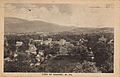
Early 20th Century view of Romney
-
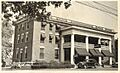
Romney's New Century Hotel, East Main Street, 1948
-
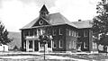
Old Romney High School, originally Romney Public School.
-
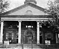
The old Hampshire County Courthouse, built in 1833


See also
 In Spanish: Romney (Virginia Occidental) para niños
