
Moorefield, West Virginia facts for kids
Quick facts for kids
Moorefield, West Virginia
|
||
|---|---|---|

Hardy County Courthouse in Moorefield
|
||
|
||

Location of Moorefield in Hardy County, West Virginia.
|
||
| Country | United States | |
| State | West Virginia | |
| County | Hardy | |
| Government | ||
| • Type | Mayor-council | |
| Area | ||
| • Total | 2.77 sq mi (7.17 km2) | |
| • Land | 2.72 sq mi (7.04 km2) | |
| • Water | 0.05 sq mi (0.13 km2) | |
| Elevation | 810 ft (247 m) | |
| Population
(2020)
|
||
| • Total | 2,527 | |
| • Estimate
(2021)
|
2,487 | |
| • Density | 889.30/sq mi (343.37/km2) | |
| Time zone | UTC-5 (Eastern (EST)) | |
| • Summer (DST) | UTC-4 (EDT) | |
| ZIP code |
26836
|
|
| Area code(s) | 304 | |
| FIPS code | 54-55588 | |
| GNIS feature ID | 1543520 | |

Moorefield is a town in West Virginia, United States. It is the main town, or county seat, of Hardy County. Moorefield is special because it sits where two rivers meet: the South Branch Potomac River and the South Fork South Branch Potomac River.
The town was officially started in 1777. It got its name from Conrad Moore, who owned the land where the town was built. In 2020, about 2,527 people lived in Moorefield.
Contents
Exploring Moorefield's Past
Moorefield is located in the beautiful South Branch Valley. This area has been home to people for thousands of years. Long ago, Native American tribes lived here. They farmed near the river and hunted in the mountains around them.
Early Native American Life
The Shawnee people lived here when the first European settlers arrived in the early 1700s. These settlers were looking for good farmland. The first main settlement was called Old Fields. This was about five miles north of where Moorefield is today.
Forts and Battles
During the French and Indian War, there were fights between the British settlers and Native American groups. To protect the valley, two forts were built near Moorefield. Fort Buttermilk was built in 1756. Fort Pleasant was also built to guard the northern part of the valley. Soldiers from these forts fought against Shawnee warriors in a battle called the Battle of the Trough in 1756.
Founding the Town
Conrad Moore owned the land where Moorefield was planned. In 1777, the government of Virginia officially made Moorefield a town. At that time, it was part of Hampshire County. Later, in 1785, Hardy County was created, and Moorefield became its county seat. Many old houses in Moorefield were built around this time. They show a mix of Federal and Greek Revival designs.
Moorefield During the Civil War
During the American Civil War, Moorefield was the site of a cavalry battle. On August 7, 1864, Union General William W. Averell's soldiers defeated Confederate General John McCausland's troops. This battle was part of the Valley Campaigns of 1864.
Getting Around Moorefield
Moorefield is connected by several important roads. U.S. Route 48 runs through the area from west to east. U.S. Route 220 goes from south to north. West Virginia Route 55 and West Virginia Route 28 also serve the town, often running alongside the U.S. highways.
Moorefield's Geography
Moorefield is located at 39°4′N 78°58′W / 39.067°N 78.967°W.
Land and Water
The town covers about 2.40 square miles (6.22 square kilometers). Most of this area is land, about 2.35 square miles (6.09 square kilometers). A small part, about 0.05 square miles (0.13 square kilometers), is water.
What's the Climate Like?
Moorefield has a climate with hot, humid summers. The winters are usually mild to cool. This type of weather is known as a humid subtropical climate.
| Climate data for Moorefield, West Virginia (1991–2020 normals, extremes 1892–1933, 1947–1959, 1967–present) | |||||||||||||
|---|---|---|---|---|---|---|---|---|---|---|---|---|---|
| Month | Jan | Feb | Mar | Apr | May | Jun | Jul | Aug | Sep | Oct | Nov | Dec | Year |
| Record high °F (°C) | 81 (27) |
86 (30) |
93 (34) |
98 (37) |
98 (37) |
105 (41) |
109 (43) |
112 (44) |
106 (41) |
102 (39) |
87 (31) |
81 (27) |
112 (44) |
| Mean daily maximum °F (°C) | 42.2 (5.7) |
46.3 (7.9) |
54.5 (12.5) |
66.9 (19.4) |
75.3 (24.1) |
83.1 (28.4) |
87.0 (30.6) |
85.5 (29.7) |
79.4 (26.3) |
68.6 (20.3) |
56.0 (13.3) |
45.7 (7.6) |
65.9 (18.8) |
| Daily mean °F (°C) | 31.3 (−0.4) |
34.2 (1.2) |
41.5 (5.3) |
52.2 (11.2) |
61.9 (16.6) |
70.4 (21.3) |
74.1 (23.4) |
72.8 (22.7) |
65.9 (18.8) |
54.6 (12.6) |
42.9 (6.1) |
34.7 (1.5) |
53.0 (11.7) |
| Mean daily minimum °F (°C) | 20.3 (−6.5) |
22.1 (−5.5) |
28.5 (−1.9) |
37.6 (3.1) |
48.5 (9.2) |
57.6 (14.2) |
61.3 (16.3) |
60.1 (15.6) |
52.4 (11.3) |
40.6 (4.8) |
29.8 (−1.2) |
23.7 (−4.6) |
40.2 (4.6) |
| Record low °F (°C) | −27 (−33) |
−25 (−32) |
−9 (−23) |
12 (−11) |
25 (−4) |
29 (−2) |
39 (4) |
38 (3) |
27 (−3) |
13 (−11) |
−1 (−18) |
−26 (−32) |
−27 (−33) |
| Average precipitation inches (mm) | 2.17 (55) |
1.71 (43) |
2.86 (73) |
3.09 (78) |
3.78 (96) |
3.69 (94) |
4.37 (111) |
3.26 (83) |
3.45 (88) |
2.47 (63) |
2.04 (52) |
2.30 (58) |
44.02 (1,118) |
| Average snowfall inches (cm) | 6.6 (17) |
4.9 (12) |
4.2 (11) |
0.0 (0.0) |
0.0 (0.0) |
0.0 (0.0) |
0.0 (0.0) |
0.0 (0.0) |
0.0 (0.0) |
0.0 (0.0) |
0.8 (2.0) |
4.9 (12) |
21.4 (54) |
| Average precipitation days (≥ 0.01 in) | 7.6 | 6.8 | 9.2 | 10.7 | 12.3 | 10.8 | 10.4 | 9.9 | 8.4 | 7.6 | 6.9 | 7.6 | 108.2 |
| Average snowy days (≥ 0.1 in) | 2.3 | 1.9 | 1.2 | 0.0 | 0.0 | 0.0 | 0.0 | 0.0 | 0.0 | 0.0 | 0.2 | 1.4 | 7.0 |
| Source: NOAA | |||||||||||||
Who Lives in Moorefield?
| Historical population | |||
|---|---|---|---|
| Census | Pop. | %± | |
| 1880 | 554 | — | |
| 1890 | 495 | −10.6% | |
| 1900 | 460 | −7.1% | |
| 1910 | 646 | 40.4% | |
| 1920 | 630 | −2.5% | |
| 1930 | 734 | 16.5% | |
| 1940 | 1,291 | 75.9% | |
| 1950 | 1,405 | 8.8% | |
| 1960 | 1,434 | 2.1% | |
| 1970 | 2,124 | 48.1% | |
| 1980 | 2,257 | 6.3% | |
| 1990 | 2,148 | −4.8% | |
| 2000 | 2,375 | 10.6% | |
| 2010 | 2,544 | 7.1% | |
| 2020 | 2,527 | −0.7% | |
| 2021 (est.) | 2,487 | −2.2% | |
| U.S. Decennial Census | |||
2010 Census Snapshot
In 2010, there were 2,544 people living in Moorefield. They lived in 1,097 households, with 624 of those being families. The town had about 1,216 homes.
The people living in Moorefield were from different backgrounds:
- 79.0% were White.
- 8.6% were African American.
- 0.4% were Native American.
- 4.7% were Asian.
- 5.4% were from other races.
- 1.8% were from two or more races.
- About 11.0% of the population identified as Hispanic or Latino.
About 27.5% of households had children under 18. Many households were married couples (37.5%). The average age in Moorefield was about 40.1 years old.
Famous People from Moorefield
Some notable people have connections to Moorefield:
- Florence V. Brittingham (1856–1891) was a poet and short story writer.
- Lyscum Elbert Crowson (1903-1993) was a Methodist minister and a leader in West Virginia.
- Willard Duncan Vandiver (1854-1932), a congressman from Missouri, was born near Moorefield. He helped make the "Show Me State" nickname popular for Missouri.
Images for kids
-
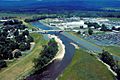
Aerial view of the business district of Moorefield.
-
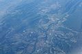
Aerial view of Moorefield and the surrounding area.
-
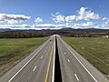
US 48 in Moorefield.


See also
 In Spanish: Moorefield (Virginia Occidental) para niños
