Fort Pearsall facts for kids

Fort Pearsall was an early fort built in 1756 in what is now Romney, West Virginia. Back then, this area was known as Pearsall's Flats, in Virginia. The fort was built to protect settlers living in the South Branch Potomac River valley from raids by Native American groups. People had started settling around present-day Romney as early as 1725, mostly hunters and traders.
Building Fort Pearsall
Fort Pearsall was first built as a log house with a strong fence, called a stockade. It was put up by two brothers, Job and John Pearsall. They built it on their land, somewhere between Indian Mound Cemetery and the South Branch Potomac River. This spot was near where the old Fort Loudoun Road crossed the river, leading to Winchester.
Even though some stories say the fort was built in 1738, it was more likely built around 1755. This was a time when forts were really needed, right after the Braddock campaign failed at the start of the French and Indian War. The Pearsall brothers probably built the stockade to keep the settlers of Pearsall's Flats safe. They also built several homes for other settlers that same year.
Fort Pearsall During Wartime
In 1755, George Washington helped supply Pearsall's stockade with food and weapons for the Virginia Regiment. This was a real army raised by the colony. The fort then had soldiers stationed there, or was "garrisoned," starting in 1756. During the French and Indian War, Captain Robert McKenzie was in charge of Fort Pearsall. Soldiers stayed at the fort at different times until 1758.
Around 1758, it's thought that about 100 people lived in the general area of Pearsall's Flats. However, it's hard to find old records to prove this number. It seems like a lot of people unless it includes a wider area. This wider area might stretch about eight miles south to The Trough and about 15 miles north to where the South Branch River meets the North Branch Potomac River.
Romney's New Name
After the fighting ended in the area, Thomas Fairfax, 6th Lord Fairfax of Cameron realized that more settlers would want to move into the South Branch Potomac Valley. He knew he could make a lot of money by selling land there. So, in 1762, Lord Fairfax sent a team to Pearsall's to officially map out the town into 100 lots.
Lord Fairfax then changed the town's name to Romney. He named it after a city called Romney in England, which was one of the Cinque Ports cities on the English Channel. For many years after, there was some confusion about who owned what land in the town. This was because the first settlers and those who bought lots from Lord Fairfax's map sometimes claimed the same land.
Fort Pearsall Today
Some stories say that Pearsall's Fort had soldiers stationed there again in 1774 for Lord Dunmore's War. However, there are no historical records to confirm this.
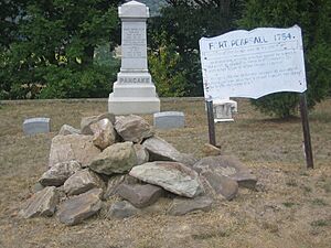
Today, you can find a special marker in Indian Mound Cemetery that remembers Fort Pearsall. It stands by the "Yellow Banks" overlooking the South Branch River. Next to the marker, there's a pile of rocks and other bits that people believe are what's left of the old fort.
 | Georgia Louise Harris Brown |
 | Julian Abele |
 | Norma Merrick Sklarek |
 | William Sidney Pittman |

