
English Channel facts for kids
Quick facts for kids English Channel |
|
|---|---|
 |
|
| Location | Western Europe; between the Celtic Sea and North Sea |
| Part of | Atlantic Ocean |
| Primary inflows | River Exe, River Seine, River Test, River Tamar, River Somme |
| Basin countries | United Kingdom France Guernsey Jersey |
| Max. length | 560 km (350 mi) |
| Max. width | 240 km (150 mi) |
| Surface area | 75,000 km2 (29,000 sq mi) |
| Average depth | 63 m (207 ft) |
| Max. depth | 174 m (571 ft) at Hurd's Deep |
| Salinity | 3.4–3.5% |
| Max. temperature | 15 °C (59 °F) |
| Min. temperature | 5 °C (41 °F) |
| Islands | Île de Bréhat, Île de Batz, Chausey, Tatihou, Îles Saint-Marcouf, Isle of Wight, Jersey, Guernsey, Alderney, Sark, Herm |
| Settlements | Bournemouth, Brighton, Plymouth, Portsmouth, Calais, Le Havre |
The English Channel is a stretch of water that separates the island of Great Britain from the rest of Europe. If you live in the UK and want to visit Europe, or vice versa, you can take a ferry across. Another option is to ride a train under the Channel in a special tunnel called the Channel Tunnel. People often call it the Chunnel. Both ferries and trains can carry cars.
The English Channel is about 563 km long and 246 km wide. Its narrowest part is the Strait of Dover, which is only 34 km wide. On a clear day, you can even see the famous white cliffs of Dover from Calais on the French side. In France, this body of water is known as La Manche, which means "The Sleeve".
People have always been fascinated by crossing the Channel. In 1875, Matthew Webb became the first person known to swim across it. He completed the swim in just under 22 hours. The first woman to achieve this amazing feat was Gertrude Ederle. By 2004, over 600 people had successfully swum the Channel. The fastest swim was by Peter Stoychev in 2007, taking only 7 hours. Today, swimming in the English Channel is generally restricted for safety reasons.
Contents
How the English Channel Was Formed
The English Channel is quite new in terms of geology. For most of the Pleistocene period, which ended about 10,000 years ago, this area was dry land.
Ancient Ice Age and Giant Floods
Before the last ice age, called the Devensian glaciation, Britain and Ireland were connected to continental Europe. A natural ridge, like a huge dam, held back a large freshwater lake. This lake was in the Doggerland region, which is now under the North Sea. During this time, most of the British Isles were covered in ice.
Meltwater from the ice sheets filled this lake. The sea level was much lower, about 120 meters (394 feet) less than it is today. Then, between 450,000 and 180,000 years ago, huge floods broke through this natural dam.
Carving the Channel
The first flood was massive, lasting for several months. It released a million cubic meters of water every second. This powerful flow created deep holes, now called the Fosses Dangeard. The water eventually broke the ridge, letting the lake empty into the Atlantic Ocean.
Later, another huge flood carved a large valley, the Lobourg Channel. This valley is about 500 meters (1,640 feet) wide and 25 meters (82 feet) deep. It runs from the southern North Sea basin through the Strait of Dover and into the English Channel. This flood left behind features like streamlined islands and grooves on the seafloor. These can still be seen today using special sonar equipment.
A river, formed by the combined Rhine and Thames rivers, flowed through this newly carved channel towards the Atlantic. These floods destroyed the land bridge that connected Britain to Europe. Even though land connections appeared sometimes when sea levels dropped, rising sea levels after the last ice age finally cut off Britain completely.
The Channel's Role in History
For a long time, the Channel made it harder for people to move to Great Britain. But in historical times, it became both an easy way for sailors to arrive and a strong natural defense. It helped stop invading armies.
Key Historical Events
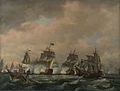
The Channel played a big role in stopping major invasions. These included the Spanish Armada in 1588, Napoleon's plans during the Napoleonic Wars, and Nazi Germany during World War II.
However, some invasions were successful. The Roman conquest of Britain and the Norman Conquest in 1066 are examples. In 1688, the Dutch also invaded successfully. The many good harbors on Britain's south coast also made the largest invasion in history possible: the Normandy Landings in 1944.
Cultural Connections
In more peaceful times, the Channel connected shared cultures. For nearly a thousand years, it linked the Celtic regions of Cornwall in England and Brittany in France. Brittany was founded by Britons who fled from Cornwall and Devon to escape Anglo-Saxon invaders. There's even a region in Brittany called "Cornouaille," just like Cornwall.
In February 1684, the Channel even froze! Ice formed a 3-mile-wide belt off the coast of Kent and a 2-mile-wide belt on the French side.
Early Routes to Britain
Evidence shows that people sailed across the Channel thousands of years ago. A very old boatyard was found on the Isle of Wight. Wheat was traded across the Channel about 8,000 years ago. This shows that ancient people had clever ways to connect with each other.
Later, during the Iron Age, there was a lot of trade between Celtic tribes in France and Britain. When Julius Caesar invaded Britain in 55 BC, he claimed the Britons had helped his enemies. Britain later became part of the Roman Empire, and trade continued until 410 AD.
After the Romans left, Germanic tribes like the Angles, Saxons, and Jutes crossed the North Sea. Many of these tribes settled in Britain, changing the local populations.
Norsemen and Normans
The Viking Age began around 793 with an attack on Lindisfarne. For the next 250 years, Viking raiders from Scandinavia controlled the North Sea. They raided towns and monasteries along the coasts and rivers. They began to settle in Britain around 851.
The region of Normandy in France was given to a Viking leader named Rollo in 911. He had attacked Paris but then made a deal with the French king. The name "Normandy" comes from Rollo's Viking (or "Northman") origins.
Rollo's descendants became the Normans. They spoke a type of French and mixed with the local people. In 1066, William the Conqueror, a descendant of Rollo, became king of England after the Norman Conquest. He also kept control of Normandy in France.
Later, in 1204, mainland Normandy was taken by France. But the Channel Islands (like Jersey and Guernsey) stayed under English control. Even today, the British monarch holds the title "Duke of Normandy" for the Channel Islands.
From the time of Elizabeth I, England focused on stopping any major European power from controlling ports across the Channel. This was to prevent invasions. In 1588, the Spanish Armada tried to invade England but was defeated by the English and Dutch navies, helped by stormy weather. This marked the start of England becoming a powerful sea nation.
The Royal Navy grew to be the strongest in the world. This allowed Britain to build its vast British Empire. During the Seven Years' War, France tried to invade Britain. But the British navy won the Battle of Quiberon Bay in 1759, stopping the invasion plans.
Another big challenge came during the Napoleonic Wars. Horatio Nelson's victory at the Battle of Trafalgar ended Napoleon's plans to invade Britain. This secured Britain's control of the seas for over a century.
World War I and II
Before World War I, the Channel was seen as a vital defense. But in 1909, Louis Blériot made the first airplane flight across the Channel. This showed that the Channel was no longer a complete barrier against enemies.
During World War I, Germany used submarine warfare as their surface fleet couldn't match the British navy. The Dover Patrol was set up to protect ships and block submarines in the Channel. On land, the Germans tried to capture Channel ports but were stopped. The naval blockade in the Channel and North Sea was a key reason for Germany's defeat in 1918.
In World War II, the Channel was again very important. In May 1940, German forces captured French ports, trapping British troops. Over 338,000 Allied soldiers were rescued from Dunkirk in Operation Dynamo. The Germans planned an invasion called Operation Sealion, but they couldn't gain control of the air over the Channel, so the invasion never happened.
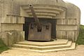
The Channel became a battleground for smaller ships and submarines. The Normandy Landings in 1944 were a massive invasion of German-occupied France by Allied troops. Many towns in Normandy suffered greatly during the fighting. The Channel Islands were the only part of the British Commonwealth occupied by Germany during the war. Life was very hard for the islanders, with food shortages and forced labor. The German troops on the islands surrendered on May 9, 1945.
Cities and Towns Along the Channel
The English side of the Channel is much more populated than the French side. Here are some of the main towns and cities:
England

- Brighton–Worthing–Littlehampton: A large area with over 460,000 people.
- Portsmouth: 442,252 people, including Gosport
- Bournemouth & Poole: 383,713 people
- Southampton: 304,400 people
- Plymouth: 258,700 people
- Torbay (Torquay): 129,702 people
- Hastings–Bexhill: 126,386 people
- Exeter: 119,600 people
- Eastbourne: 106,562 people
- Dover: 39,078 people
France

- Le Havre: 248,547 people
- Calais: 104,852 people
- Boulogne-sur-Mer: 92,704 people
- Cherbourg: 42,318 people
- Saint-Malo: 50,675 people
- Dieppe: 42,202 people
Channel Islands
- Saint Helier, Jersey: 28,310 people
- Saint Peter Port, Guernsey: 16,488 people
Busy Shipping Lanes

The English Channel is the busiest seaway in the world. Over 500 ships pass through it every day. Ships travel between the UK and Europe, and also between the North Sea and the Atlantic Ocean.
To keep ships safe, a special system called the Dover TSS was set up in 1971. It's the world's first radar-controlled Traffic Separation Scheme. This system makes ships traveling north use the French side of the Channel. Ships going south must use the English side. There's a safe zone between these two lanes.
Even with these rules, accidents can happen. In 2002, a ship carrying luxury cars sank after hitting another ship in fog. The next day, another ship ran into the wreckage. Luckily, no one was hurt in these incidents. While the system isn't perfect, it has greatly reduced accidents.
Modern GPS systems help ships follow their routes precisely. However, in one accident in 2001, GPS might have actually contributed to a collision. Two ships were following each other too closely on an automated course.
Environmental Concerns
Because so many ships use the Channel, it faces environmental risks. Accidents involving ships carrying dangerous goods or oil spills can cause pollution. In fact, over 40% of pollution threats in the UK happen in or near the Channel. For example, in 2007, a ship carrying dangerous cargo had to be beached in Lyme Bay, a protected area, after being damaged.
Travel and Tourism

Ferry Services
Ferries are a popular way to cross the Channel. However, the number of ferry routes has gone down since the Channel Tunnel opened.
Channel Tunnel
The Channel Tunnel is a major way to travel between the UK and France. It was first thought of in the early 1800s but finally opened in 1994. Now, it's common to take the Eurostar train between Paris or Brussels and London. Freight trains also use the tunnel. You can even put your car, coach, or lorry on special Eurotunnel Shuttle trains to cross between Folkestone and Calais.
Tourism Along the Coast

Coastal towns along the Channel, like Brighton in England and Deauville in France, became popular tourist spots in the 1800s. They were favored by royalty and wealthy families. This led to the development of seaside tourism around the world. Short trips across the Channel for fun are sometimes called "Channel Hopping."
Languages and Culture

The two main cultures along the Channel are English on the north side and French on the south. But there are also some smaller languages spoken or once spoken in the area:
- Germanic Languages:
- English
- Dutch – called "het Kanaal" (the Channel)
- Romance Languages:
- French – called "La Manche"
- Gallo – also "Manche"
- Norman, including languages spoken on the Channel Islands:
- Guernesiais – "Ch'nal"
- Jèrriais – "Ch'na"
Channel Crossings: A History of Firsts
The English Channel is famous for being a place where many new ways of crossing have been tried. Because it's relatively narrow and doesn't have dangerous currents, it's been a goal for many inventors and adventurers.
Long ago, prehistoric people sailed from mainland Europe to England. At the end of the last Ice Age, the sea level was so low that you could even walk across!
Early Steam Crossings
In March 1816, Pierre Andriel crossed the Channel on the Élise, one of the first steam-powered ships to travel at sea. The paddle steamer Defiance was the first steamer to cross to Holland in May 1816.
In 1821, the English-built paddle steamer Rob Roy became the first passenger ferry to cross the Channel. It could make the journey in about three hours.
Modern Crossings
In 1968, the Mountbatten class hovercraft began commercial service. It could cross from Dover to Boulogne in about 35 minutes. The fastest crossing by a commercial car-carrying hovercraft was 22 minutes in 1995.
By Air
The first aircraft to cross the Channel was a balloon in 1785. It was piloted by Jean Pierre François Blanchard (France) and John Jeffries (US). In 1909, Louis Blériot (France) piloted the first airplane to cross.
By Swimming
The sport of Channel swimming started in the late 1800s. Captain Matthew Webb made the first observed swim from England to France in 1875. It took him almost 22 hours.
In 1927, the Channel Swimming Association (CSA) was created to check and approve swimmers' claims. Today, two organizations, CSA (Ltd) and the Channel Swimming and Piloting Federation (CSPF), oversee these swims. By the end of 2005, 811 people had completed 1,185 verified crossings. The fastest verified swim was by Trent Grimsey in 2012, taking only 6 hours and 55 minutes.
The Strait of Dover is the busiest stretch of water in the world. Special international laws guide how unusual crossings can happen to ensure safety.
By Car
On September 16, 1965, two Amphicars, which are cars that can also go in water, crossed from Dover to Calais.
Images for kids
-
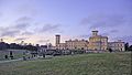
Osborne House, the summer home of Queen Victoria on the Isle of Wight. Coastal towns along the Channel became popular resorts in the 1800s.
-
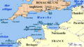
Map of the Channel area with French names.
-
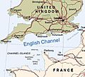
Map of the English Channel.
-
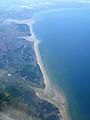
The Strait of Dover viewed from France, looking towards England. The white cliffs of Dover are visible on a clear day.
-
Three French river mouths. Top to bottom: the Somme, the Authie and the Canche.
-
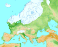
Europe during the Last Glacial Maximum about 20,000 years ago.
-
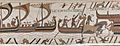
A scene from the Bayeux Tapestry, showing ships and horses landing in England.
-
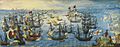
The Spanish Armada off the English coast in 1588.
-
The Battle of Quiberon Bay which ended the French invasion plans in 1759.
-
A German gun emplacement from World War II in Normandy.


See also
 In Spanish: Canal de la Mancha para niños
