Chausey facts for kids

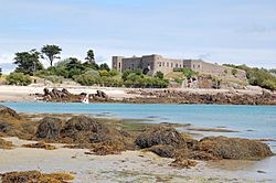
The Fort, Grande Île
|
|
|
Chausey (France)
|
|
| Geography | |
|---|---|
| Location | English Channel |
| Coordinates | 48°52′13″N 1°49′21″W / 48.87028°N 1.82250°W |
| Major islands | Grande Île |
| Administration | |
|
France
|
|
| Region | Normandy |
| Department | Manche |
| Commune | Granville |
| Demographics | |
| Population | 30 (1999) |
The Chausey Islands are a group of small islands, tiny islets, and rocks. They are located off the coast of Normandy, a region in France. You can find them in the English Channel.
Chausey is about 17 kilometers (11 miles) from Granville, a town in France. It is part of the Granville area. Even though Chausey is geographically close to the other Channel Islands (like Jersey and Guernsey), it is French territory. Because of this, it is usually not grouped with the other Channel Islands. There are no regular boats between Chausey and the other Channel Islands. However, you can take a shuttle boat from Granville to Chausey several times a day, depending on the time of year.
The name "Chausey" likely comes from an old Norse word, -ey, which means "island." You can see this same ending in names like Jersey, Guernsey, and Alderney.
Contents
History of the Chausey Islands
Early History and Ownership Changes
In the year 933, the Duchy of Normandy took control of the Channel Islands, including Chausey. Later, in 1022, Duke Richard II gave Chausey to the monks of Mont Saint-Michel. These monks built a small monastery on the main island, called Grande Île.
After William the Conqueror became King of England in 1066, the islands became part of the Kingdom of England. But in 1204, the King of France, Philip Augustus, took over mainland Normandy. He tried to take the Channel Islands too, but he didn't succeed.
A treaty in 1259 confirmed that England had lost Normandy. However, England kept the Channel Islands. Another treaty in 1360 made it clear that the English King did not have to serve the French King for these islands.
Rivalry and Smuggling Activities
For a long time, England and France argued over who owned Chausey. The UK government once said Chausey belonged to England until about 1764. But Chausey has actually been French for many centuries. It was managed by Jersey until 1499. For unknown reasons, people from Jersey gave it up to the French. One idea is that it was too expensive to control.
Sailors involved in illegal trade loved Chausey. Its many islands and hidden channels were perfect for smuggling and even piracy. The "Sound" and "Passe Beauchamp" were secret places for boats to hide.
Forts and Modern Use
Fort Matignon and Other Defenses
A fort called Matignon was built in 1559. It had strong walls, a round tower, and rooms for storage and animals. It was made bigger in 1740. However, the English destroyed this fort in 1744.
A new fort was built on the other side of the island. The English destroyed that one too, in 1756.
The Current Fort
In 1859, Napoléon III ordered the building of the fort you see today. It was finished by 1866. This fort was briefly used as a prison in 1871. It stopped being a military site in 1906.
During World War I, about 300 German and Austrian prisoners of war were held there. Later, a car engineer named Louis Renault bought the fort. He fixed it up between 1922 and 1924. It became known as Château Renault and he used it as a quiet getaway. During World War II, German soldiers stayed in the fort. Today, several fishermen live there.
Geography of Chausey
Islands and Tides
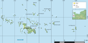
Grande-Île is the main island in the Chausey group. It is about 1.5 kilometers (0.9 miles) long and 0.5 kilometers (0.3 miles) wide. This island is just a small part of a much larger group of islands that appear at low tide.
At low tide, there are 365 islands and rocks in Chausey. But at high tide, most of them are covered by water, leaving only 52 islands visible. The total area of the islands can grow from a few dozen hectares at high tide to about 2,000 hectares (4,900 acres) at low tide. This happens because the difference between low and high tide is huge here, up to 14 meters (46 feet). This is one of the biggest tidal ranges in Europe!
The islands are made of granite rock. Over time, the sea and wind have shaped them. Some parts of Chausey are connected by sandbars that appear at low tide.
Life and Economy on Grande Île
Grande Île is the only island where people live all year round. About 30 people call it home. In the summer, the population grows a lot because of tourism. Nearly 200,000 visitors come to Chausey each year.
There are several businesses for tourists on the island. These include a hotel, a restaurant, and a shop. Besides tourism, fishing is the main way people make a living. Fishermen catch lobsters, shrimp, conger eels, sea bass, and mullet. They also farm mussels and oysters. Until 1989, there was even a cattle farm on the island.
The granite from Chausey was once mined and sent to other places. Some of this stone was used to build the famous Mont Saint-Michel.
Boats and Traditions
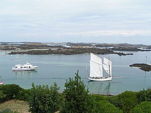
The traditional boats of Chausey are the doris and the canot chausiais. A doris is a flat-bottomed boat, usually moved by oars or an engine. Fishermen use these boats. The canot chausiais is a small sailing boat used for fun.
Every August, the Chausey Regatta takes place. This is a boat race festival that lasts all weekend. It's a fun time when many boat races are held.
See also
 In Spanish: Islas Chausey para niños
 | Roy Wilkins |
 | John Lewis |
 | Linda Carol Brown |


