
Normandy facts for kids


.svg)
Normandy (French: Normandie) is a region in northern France. People from Normandy are called Normans. The name Normandy comes from the "Northmen" or Vikings. These Vikings settled in the area. The group that settled near Rouen was led by Rollo. They became the Normans.
Normandy is also famous for a big event in World War II. This was when the Allied forces invaded France. This invasion is known as D-Day. The Battle of Normandy was the start of the Allies freeing Europe from Nazi Germany.
Contents
History of Normandy
Early History and Ancient People
Archaeological finds show that people lived in Normandy a very long time ago. This was in prehistoric times. For example, cave paintings have been found in Gouy and Orival. Many large stone structures called megaliths are also in Normandy. Most of them were built in a similar way.
Groups of Belgae and Celts, known as Gauls, came to Normandy. This happened in the 4th and 3rd centuries BC. We know a lot about them from Julius Caesar's book, de Bello Gallico. Caesar wrote about different Gaulish groups. They lived in towns surrounded by walls.
In 57 BC, the Gauls tried to fight Caesar's army together. Their leader was Vercingetorix. The Normans lost an important battle at Alesia. They kept fighting until 51 BC. That's when Caesar finished taking over Gaul. Normandy then became part of Armorica under Roman rule.
The Duchy of Normandy
The duchy of Normandy started in the year 911. Charles the Simple, who was King of France, gave land near Rouen to Rollo. Rollo was a leader of the Vikings. This agreement is called the Treaty of St. Clair-sur-Epte. More land was given to the Normans in 924 and 933.
The Duke of Normandy, William the Conqueror, invaded England in 1066. This happened after King Edward the Confessor died. William believed he should be the King of England. But King Harold II had already crowned himself king.
King Harold's Saxon army and William's Norman army fought. This was at the Battle of Hastings on October 14 1066. King Harold was killed in the battle. On December 25 1066, William was crowned King of England. He became known as 'William I'.
Normandy and France
The historic duchy includes two regions of France: Upper Normandy and Lower Normandy. The Channel Islands are also part of the duchy of Normandy. However, they are not part of France.
For a long time, the whole duchy was not part of France. In 1205, Philip II of France took all the French land from King John of England. After this, Normandy became a region within France.
World War II Invasion of Normandy

During World War II (1939–1945), Germany controlled Normandy. The town of Dieppe was where the Dieppe Raid happened. This raid was not successful. It was carried out by Canadian and British forces.
The Allies (Britain, the United States, and Canada) started the D-Day landings on June 6, 1944. This was code-named 'Operation Overlord'. Nearly 160,000 Allied soldiers took part in this invasion from the sea. They used about 7,000 ships and landing craft. About 12,000 planes dropped paratroopers hours before the sea attack.
The Germans were defending their strongholds above the beaches. Towns like Caen, Cherbourg, Carentan, and Falaise suffered many losses. This was during the Battle of Normandy. The German defenders fought hard. But they were always pushed back by the huge Allied forces.
The battle for Normandy continued until the closing of the Falaise pocket. After that, Le Havre was freed. Allied forces then moved into France and finally Germany. This was a very important moment in the war. It led to the French government being restored. The rest of Normandy was freed on May 9, 1945. This was when the German control of the Channel Islands also ended.
Geography of Normandy

The old duchy of Normandy covered the lower Seine area. It also included the Pays de Caux and the region to the west. This stretched through the Pays d'Auge to the Cotentin Peninsula. The region's northern coasts are next to the English Channel.
Normandy has granite cliffs in the west. There are limestone cliffs in the east. In the middle of the region, there are long beaches. The unique bocage hedges are common in western Normandy. The highest point is the Signal d'Écouves. It is 417 meters (1,368 feet) high.
Normandy does not have many forests. Eure has the most wooded areas. About 20% of Eure is forest. Today, about 3.45 million people live in Normandy.
Images for kids
-
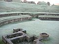
Gallo-Roman theatre in Lillebonne
-
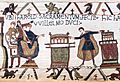
Bayeux Tapestry (Scene 23): Harold II swearing oath on holy relics to William the Conqueror
-
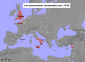
Norman possessions in the 12th century
-
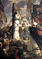
Joan of Arc burning at the stake in the city of Rouen, painting by Jules Eugène Lenepveu
-
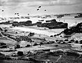
Allied invasion of Normandy, D-Day, 1944
-
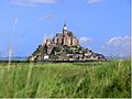
The medieval island of Mont-Saint-Michel, the most visited monument in Normandy
-
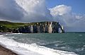
The Arche and the Aiguille of the cliffs of Étretat
-
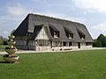
A typical Norman thatched building. This is now a village hall
-
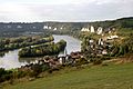
The Seine in Les Andelys
-
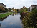
The Bresle
-
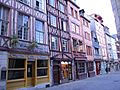
Half-timbered houses in Rouen
-
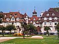
A Norman style construction in Deauville
-
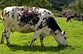
Normande cow
-
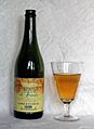
Cider from Normandy
-
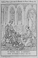
Wace presents his Roman de Rou to Henry II, Illustration 1824
-
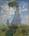
Claude Monet, Woman with a Parasol – Madame Monet and Her Son, 1875
-
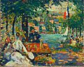
Robert Antoine Pinchon, Un après-midi à l'Ile aux Cerises, Rouen, oil on canvas, 50 x 61.2 cm
-
Coat of arms of Jersey


.jpg)


See also
 In Spanish: Normandía para niños
