
Mont-Saint-Michel facts for kids
Quick facts for kids
Mont-Saint-Michel
|
||
|---|---|---|

A view of Mont-Saint-Michel from the air at sunrise.
|
||
|
||

Mont-Saint-Michel
Location in France

Mont-Saint-Michel
Location in Normandy
|
||
| Country | France | |
| Region | Normandy | |
| Department | Manche | |
| Arrondissement | Avranches | |
| Canton | Pontorson | |
| Intercommunality | Communauté d'agglomération Mont-Saint-Michel-Normandie | |
| Area
1
|
4.00 km2 (1.54 sq mi) | |
| Time zone | UTC+01:00 (CET) | |
| • Summer (DST) | UTC+02:00 (CEST) | |
| INSEE/Postal code |
50353 /50116
|
|
| Elevation | 5–80 m (16–262 ft) | |
| UNESCO World Heritage Site | ||
| Part of | Mont-Saint-Michel and its Bay | |
| Criteria | Cultural: i, iii, vi | |
| Inscription | 1979 (3rd Session) | |
| Area | 6,560 hectares (16,200 acres) | |
| Buffer zone | 57,510 hectares (142,100 acres) | |
| 1 French Land Register data, which excludes lakes, ponds, glaciers > 1 km2 (0.386 sq mi or 247 acres) and river estuaries. | ||
.svg)
Mont-Saint-Michel (which means Saint Michael's Mount) is a famous island in Normandy, France. It's known as a tidal island, which means it's connected to the mainland at low tide but surrounded by water at high tide.
The island is located about one kilometer (0.6 miles) off the coast. While the island itself is small, it is home to a stunning abbey that makes it look like a castle from a fairy tale. As of 2019, only 29 people live on the island.
Its location made it a perfect spot for defense. When the tide came in, it was impossible for enemies to attack. Because of this, the island was never captured during the Hundred Years' War. Later, its strong defenses made it a good place to use as a prison.
Today, Mont-Saint-Michel and its bay are a UNESCO World Heritage Site, recognized in 1979 for their beauty and history. It is one of the most popular places to visit in France, with over three million visitors each year.
Contents
Geography and Nature
How the Island Was Formed
A long time ago, in prehistoric times, Mont-Saint-Michel was not an island but part of the dry land. As sea levels rose over thousands of years, the ocean wore away the softer land around it.
The mount is made of a hard rock called granite. This strong rock resisted the ocean's power, while the land around it washed away. This is how Mont-Saint-Michel and other nearby rocky hills were left standing in the bay. The island is about 960 meters (3,150 ft) around and its highest point is 92 meters (302 ft) above sea level.
The Amazing Tides
The tides around Mont-Saint-Michel are some of the most dramatic in Europe. The difference between high and low tide can be as much as 14 meters (46 feet). In the past, pilgrims who walked to the island had to be very careful. The tide could come in very quickly, trapping people on the sand.
The area around the island has special salt marsh meadows. Sheep graze on these meadows, and their meat has a unique, delicious flavor. This local food is called agneau de pré-salé (salt-meadow lamb) and is served in restaurants on the mount.
Becoming an Island Again


For a long time, a raised road called a causeway connected the island to the mainland. This road, built in 1879, stopped the sea from washing away the sand and mud around the island. Over time, so much silt built up that Mont-Saint-Michel was in danger of becoming permanently attached to the land.
To fix this, a major project began in 2006. A new dam was built to help the river and the tides wash away the extra silt. The old causeway was replaced with a light, elegant bridge that lets the water flow freely. Now, Mont-Saint-Michel is truly an island again at high tide.
History of the Mount
The Legend Begins
Before the first church was built, the island was called Mont Tombe. According to legend, in the year 708, the archangel Michael appeared to Aubert, the bishop of a nearby town. The archangel told him to build a church on the island. This is how the mount got its name.
The mount became very important in 933 when it officially became part of Normandy. It is even shown in the famous Bayeux Tapestry, which tells the story of the Norman conquest of England in 1066. One scene shows knights being rescued from the quicksand in the bay.

A Mighty Fortress
During the Hundred Years' War (1337–1453), English armies tried to capture Mont-Saint-Michel twice but failed. The French defenders used the island's natural protection and strong walls to fight them off.
In 1433, the English attacked with large cannons called bombards. When they gave up the attack, they left two of these huge cannons behind. Today, you can still see these cannons on display at Mont-Saint-Michel.

From Abbey to Prison
After the French Revolution in 1789, the abbey was closed and turned into a prison. Because it was so hard to escape from the island, it was used to hold important political prisoners.
By the 1800s, the buildings were falling apart. Famous writers like Victor Hugo started a campaign to save this national treasure. The prison was finally closed in 1863, and work began to restore the beautiful abbey.
Modern Times

During World War II, German soldiers used the island as a lookout post. After the D-Day invasion in 1944, American soldiers liberated the island.
In 1979, Mont-Saint-Michel was named a UNESCO World Heritage Site. This recognized its importance for its history, architecture, and amazing natural setting. In June 2023, the abbey celebrated its 1,000-year anniversary.
The Abbey's Amazing Architecture

Building the abbey on top of a steep, rocky hill was a huge challenge. In the 11th century, an Italian architect named William of Volpiano designed the first church in the Romanesque style. He built strong underground rooms, or crypts, to support the weight of the heavy stone church above.
In 1204, a fire damaged parts of the abbey. The King of France, Philip Augustus, gave money to rebuild it in the new Gothic style. This new style allowed for taller buildings with bigger windows, creating the beautiful section of the abbey known as La Merveille (The Marvel).
Over the centuries, more towers and strong walls were added, making the mount the incredible fortress-abbey we see today.
How the Mount Grew Over Time
-
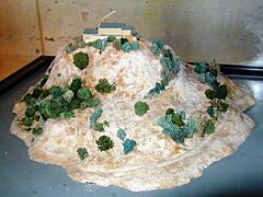
A model of the mount in the 10th century.
-
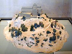
The mount in the 11th and 12th centuries.
-
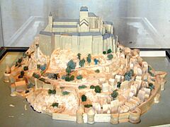
The mount in the 17th and 18th centuries.
-
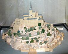
The mount as it looks today.


Life on the Island Today
.jpg)
Even though millions of people visit, very few people live on the island year-round.
| Historical population of Le Mont-Saint-Michel | |||||||||||||||||||||||||||||||||||||||||||||||||||||||||||||||||||||||||||||||||||||||||||||||||||||||||||||||||||||||
|---|---|---|---|---|---|---|---|---|---|---|---|---|---|---|---|---|---|---|---|---|---|---|---|---|---|---|---|---|---|---|---|---|---|---|---|---|---|---|---|---|---|---|---|---|---|---|---|---|---|---|---|---|---|---|---|---|---|---|---|---|---|---|---|---|---|---|---|---|---|---|---|---|---|---|---|---|---|---|---|---|---|---|---|---|---|---|---|---|---|---|---|---|---|---|---|---|---|---|---|---|---|---|---|---|---|---|---|---|---|---|---|---|---|---|---|---|---|---|---|
|
|
|
|||||||||||||||||||||||||||||||||||||||||||||||||||||||||||||||||||||||||||||||||||||||||||||||||||||||||||||||||||||
| From the year 1962 on: No double counting—residents of multiple communes (e.g., students and military personnel) are counted only once. Source: EHESS and Insee |
|||||||||||||||||||||||||||||||||||||||||||||||||||||||||||||||||||||||||||||||||||||||||||||||||||||||||||||||||||||||
Since 2001, a community of monks and nuns from the Monastic Fraternities of Jerusalem have lived on Mont-Saint-Michel. They hold regular prayer services in the abbey, continuing the island's long tradition as a spiritual place.
Dolphins in the Bay
During the summer, dolphins can sometimes be seen in the bay around Mont-Saint-Michel. They are attracted to the small fishing boats used by local fishermen. The dolphins seem to know the fishermen are friendly and enjoy playing in the currents made by the boats' propellers.
Sister Islands
Mont-Saint-Michel has a "twin" in Cornwall, England, called St Michael's Mount. Both are tidal islands with a church on top and share a similar history.
The island is also twinned with Itsukushima Shrine in Hatsukaichi, Japan. This shrine is also a beautiful UNESCO World Heritage Site built over the water.

Visiting the Mount
In the Middle Ages, people known as Miquelots would walk for hundreds of miles on a religious journey, or pilgrimage, to visit the abbey. Today, visitors can still walk along some of these ancient paths to reach the mount. Most visitors, however, use a shuttle bus or walk across the bridge to explore the island's narrow streets, shops, and historic abbey.
See also
- Carolingian architecture
- French Romanesque architecture
- La Mère Poulard
- List of Carolingian monasteries
- Mont-Saint-Michel Abbey
- Mont Saint Michel and Chartres (1904) by Henry Adams
- Saint-Malo
- St Michael's Mount, England
