
Isle of Wight facts for kids
Quick facts for kids
Isle of Wight
|
|||||||||||||||||||||||||||||||||||||||||||||||||
|---|---|---|---|---|---|---|---|---|---|---|---|---|---|---|---|---|---|---|---|---|---|---|---|---|---|---|---|---|---|---|---|---|---|---|---|---|---|---|---|---|---|---|---|---|---|---|---|---|---|

An image of the Isle of Wight from the ISS
|
|||||||||||||||||||||||||||||||||||||||||||||||||
|
|||||||||||||||||||||||||||||||||||||||||||||||||
 |
|||||||||||||||||||||||||||||||||||||||||||||||||
| Sovereign state | United Kingdom | ||||||||||||||||||||||||||||||||||||||||||||||||
| Constituent country | England | ||||||||||||||||||||||||||||||||||||||||||||||||
| Region | South East | ||||||||||||||||||||||||||||||||||||||||||||||||
| Time zone | UTC±00:00 (Greenwich Mean Time) | ||||||||||||||||||||||||||||||||||||||||||||||||
| • Summer (DST) | UTC+01:00 (British Summer Time) | ||||||||||||||||||||||||||||||||||||||||||||||||
| Member of Parliament |
|
||||||||||||||||||||||||||||||||||||||||||||||||
| Police | Hampshire and Isle of Wight Constabulary | ||||||||||||||||||||||||||||||||||||||||||||||||
|
|||||||||||||||||||||||||||||||||||||||||||||||||

The Isle of Wight (pronounced WYTE) is a special island and county in England. It sits in the English Channel, just a short distance from the coast of Hampshire. It is the largest island in England and the second most populated.
Locals often call it "The Island." It has been a popular holiday spot since Victorian times. People love its mild weather, beautiful coastlines, and green landscapes. The island is also famous for its cliffs and quarries, which are full of dinosaur fossils.
Many famous people have lived here, including poets Algernon Charles Swinburne and Alfred, Lord Tennyson. Queen Victoria even built her summer home, Osborne House, on the island. The Isle of Wight has a history of building boats, flying boats, hovercraft, and even Britain's space rockets.
Today, the island hosts big music events, like the Isle of Wight Festival. This festival was once one of the largest rock music events ever held. The island also plays an important role in protecting the nearby ports of Southampton and Portsmouth.
Contents
- Understanding the Island's Name
- A Look Back at the Island's History
- How the Island is Governed
- Island Geography and Environment
- Island Economy and Industries
- Island Culture and Identity
- Island Landmarks to Explore
- Getting Around the Island
- Education on the Island
- Famous People from the Island
- Places Around the World Named After the Island
- Images for kids
- See also
Understanding the Island's Name
The Isle of Wight has had many names throughout history. The Romans called it Vectis or Vecta. In Old English, it was known as Wiht. The modern Welsh name is Ynys Wyth, meaning "island of Wyth".
These names all come from a similar root word. It might mean 'place of the division'. This is because the island divides the two parts of the Solent sea. People born on the island are sometimes called "caulkheads." People who move to the island from the mainland are called "overners."
A Look Back at the Island's History
How the Island Was Formed
Long ago, during the Ice Age, sea levels were much lower. The area that is now the Solent was a river. As the ice melted and sea levels rose, the river valley flooded. This created the island we know today.
Early Inhabitants and Roman Times
The first people on the island were hunter-gatherers. They arrived during the Paleolithic (Old Stone Age). Later, during the Neolithic era, the island became a trading hub. There is evidence of Bronze Age tin trading.
The Romans captured the island around 85 BC. They called it Vectis. The Romans did not build towns here. However, they built many Roman villas. This shows that farming was successful.
From Dark Ages to Norman Rule
During the Dark Ages, the island was a kingdom called Wihtwara. It was ruled by King Arwald. In 685, it was invaded and became part of Wessex. It was the last part of England to become Christian.
The island suffered many attacks from Vikings. They often used it as a winter base. After the Norman Conquest in 1066, the island was given to William FitzOsbern. He founded Carisbrooke Priory and Carisbrooke Castle.
For almost 200 years, the island was like its own small kingdom. It was ruled by the de Redvers family. In 1293, the last owner, Isabella de Fortibus, sold it to King Edward I. After that, the English crown controlled the island.
Fortifications and Royal Connections
The island continued to face attacks. In 1377, French raiders burned towns and attacked Carisbrooke Castle. Under Henry VIII, the island was fortified. Forts were built at Yarmouth, Cowes, East Cowes, and Sandown.
In 1545, a French invasion was stopped by local fighters. During the English Civil War, King Charles I fled to the island. He hoped to find safety, but was instead imprisoned in Carisbrooke Castle.

Modern Era and Innovations
In the 1860s, many forts were built on the island. These were called Palmerston Forts. They included The Needles Battery and Fort Victoria. This was due to fears of a French invasion.
Queen Victoria loved the island. She made Osborne House her winter home. This made the island a popular holiday spot. Many famous people visited, including Alfred, Lord Tennyson and Charles Dickens.
Queen Victoria died at Osborne House in 1901. During her reign, the world's first radio station was set up. Marconi built it in 1897 at the Needles Battery. The island is now home to the National Wireless Museum.
During the Second World War, the island was often bombed. It was close to German-occupied France. It also played a role in developing space rockets. The Black Arrow and Black Knight rockets were tested here.


The Isle of Wight Festival started in 1968. The 1970 festival was huge, with about 600,000 people. It was one of the last performances by Jimi Hendrix. The festival was brought back in 2002 and is now an annual event.
How the Island is Governed
The Isle of Wight is a special county in England. It has its own local council called the Isle of Wight Council. This council manages local services for the island.
Until 2024, the island had one MP. Now, it has two separate areas, each with its own MP. These are Isle of Wight East and Isle of Wight West. These MPs represent the island in the UK Parliament.
The council is currently led by a group called the Alliance Coalition. This group includes independent councillors and members of other parties.
Island Geography and Environment
Island Shape and Landscape

The Isle of Wight is shaped a bit like a diamond. It covers an area of about 380 square kilometers. More than half of the island is a protected area. This is called the Isle of Wight Area of Outstanding Natural Beauty.
The island has diverse landscapes. It is often called "England in miniature." In 2019, the whole island became a UNESCO Biosphere Reserve. This recognizes the balance between people and nature.
West Wight is mostly countryside. It has dramatic coastlines and chalk hills. The highest point is St Boniface Down, which is 241 meters high. The island also has unique soft cliffs and sea ledges. These are important for wildlife.
Rivers and Tides
The island has three main rivers. The River Medina flows north into the Solent. The Eastern Yar flows northeast to Bembridge Harbour. The Western Yar flows from Freshwater Bay to Yarmouth.
The north coast of the island has four high tides each day. This is unusual. The first tide from the west starts to go out. Then, a stronger flow from the south of the island comes in. This creates a second high tide.
Island Geology and Dinosaurs
The Isle of Wight is made of different types of rocks. These rocks are from about 30 to 127 million years ago. The island's structure shows a clear change in rock ages. Younger rocks are in the north, older rocks in the south.
The northern part of the island has mostly clay. The southern part has chalk hills. All the rocks on the island are sedimentary. This means they formed from layers of sand, mud, and shells.
These rocks are full of fossils. Many can be seen on the beaches as the cliffs wear away. The island is one of the most important places in Europe for dinosaur fossils. Eroding cliffs often reveal new remains.
Dinosaur bones and fossilized footprints can be found. They are especially common at Yaverland and Compton Bay. Because of this, the island is nicknamed "Dinosaur Island." The Dinosaur Isle museum opened in 2001.
-
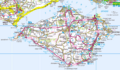
Ordnance Survey map of the island
-
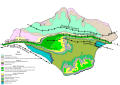
Geological map of the island
-
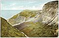
Blackgang Chine, circa 1910
-
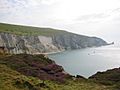
A view of the Needles and Alum Bay


Island Climate
The Isle of Wight has a mild and sunny climate. This makes it a popular holiday spot. It also has a longer growing season for plants. Some years, there is almost no snow in winter.
The area around Lower Ventnor has a special microclimate. This is because it is sheltered by the hills. The island gets between 1,800 and 2,100 hours of sunshine each year.
Island Plants and Animals
The Isle of Wight is one of the few places in England with many red squirrels. This is because there are no grey squirrels here. Other animals include badgers, hedgehogs, and foxes. There are also rare bats and dormice.
The island has several types of deer. Some, like the European red deer and roe deer, are native. They are known to swim to the island from the mainland. Other deer, like the small Chinese Reeve's muntjac, are also present.
A group called "Save Our Hedgehogs Isle of Wight" helps hedgehogs. "Isle of Wight Deer Conservation" monitors the deer. There is also a group of wild goats on Ventnor's downs.
The Glanville fritillary butterfly mostly lives on the island's cliffs. In 2002, the pyramidal orchid was chosen as the island's county flower. The waters around the island are also protected. They are home to important marine life.

Main Towns and Villages

- Newport is the main town in the center of the island. It has about 25,000 people. It is the island's main shopping area.
- Ryde is the largest town, with about 30,000 people. It is in the northeast. Ryde has the oldest seaside pier in England.
- Cowes is a famous international sailing center. It hosts the annual Cowes Week event.
- East Cowes is known for Osborne House. It was also home to Saunders-Roe, a company that built flying boats and hovercraft.
- Sandown is a popular seaside resort. It has the Wildheart Animal Sanctuary and the Dinosaur Isle museum.
- Shanklin is just south of Sandown. It attracts tourists with its sunny beaches and Shanklin Chine.
- Ventnor is built on the steep slopes of St Boniface Down. It has a small harbor called Ventnor Haven.

Island Economy and Industries
What the Island Produces
The biggest industry on the island is tourism. But it also has important farming. Farmers grow crops like tomatoes and cucumbers. The island's warmer climate helps these crops grow well.
Garlic has been grown in Newchurch for many years. Some of it is even sent to France. This led to the annual Garlic Festival. It is one of the biggest local events.
The island also has two vineyards. One of them, at Adgestone, is very old. Lavender is grown for its oil.
Manufacturing and Innovation
Maritime industries have a long history here. This includes making sailcloth and building boats. The company GKN operates what used to be the British Hovercraft Corporation. This company built the world's first hovercraft.
Another important industry is composite materials. These are used by boat-builders. They are also used by Vestas, which makes wind turbine blades. Vestas has a factory and testing facilities on the island.
Britten-Norman builds airplanes at Bembridge Airfield. They make the Islander and Trislander aircraft.
Island Services
Tourism and Heritage Attractions
The island's history and natural beauty help its tourist economy. Many people visit for holidays focused on wildlife and geology. The island is still a popular place for coach tours.

Most towns and villages offer places to stay. These include hotels, hostels, and camping sites. In 1999, the island had 2.7 million visitors.
The island once had ten pleasure piers. Today, only a few remain. These include the railway pier at Ryde and piers at Sandown, Totland Bay, and Yarmouth.
Blackgang Chine is the oldest theme park in Britain. It opened in 1843. It still displays the skeleton of a whale found in 1844.
The island is also great for walking and cycling holidays. The Isle of Wight Coastal Path is 70 miles long. It follows the coastline as much as possible. An annual walking festival attracts many visitors.
Local Media
The main local newspaper is the Isle of Wight County Press. A newer free newspaper, the Isle of Wight Observer, also exists. Online news can be found on Island Echo and On the Wight.
The island has a local commercial radio station, Isle of Wight Radio. It also has a community radio station, Vectis Radio. These stations provide local news and music.
Island Culture and Identity
Local Language and Dialect
The local accent is similar to the traditional accent of Hampshire. It has some dropped consonants and longer vowel sounds. It sounds a bit like the West Country dialects.
The island has its own special words. Some are still used, like nipper (a young boy). Others are unique to the island. For example, an "overner" is someone from the mainland. A "caulkhead" is someone born on the island.
Island Identity
The Isle of Wight was once part of Hampshire. But in 1890, it became its own county. In 1974, it became a full ceremonial county. This means it has its own special status.
In 2009, the first general flag for the county was created. Island residents often call the island "The Island." They sometimes call the UK mainland "North Island."
To celebrate the island's identity, an Isle of Wight Day was started in 2016.
Sports and Music
Sports are a big part of the island's culture. These include golf, marathons, cycling, and sailing.
The island is famous for the Isle of Wight Festival. In 1970, Jimi Hendrix headlined the festival. It attracted about 600,000 people. Bands like The Bees, Level 42, and Wet Leg are from the island.
Island Landmarks to Explore
| Key | |
| Owned by the National Trust | |
| Owned by English Heritage | |
| Owned by the Forestry Commission | |
| A Country Park | |
| An Accessible open space | |
| Museum (free) | |
| Museum (charges entry fee) | |
| Heritage railway | |
| Historic House | |
- Alum Bay
- Appuldurcombe House

- Amazon World Zoo

- Bembridge Lifeboat Station
- Blackgang Chine

- Brading Roman Villa

- Carisbrooke Castle

- Classic Boat Museum, East Cowes
- Compton Bay
- Dimbola Lodge
- Dinosaur Isle
- Fort Victoria

- Godshill village and model village
- Isle of Wight Bus & Coach Museum
- Isle of Wight Steam Railway

- Isle of Wight Zoo, Yaverland
- Medina Theatre
- The Needles

- Newport Roman Villa
- Osborne House
- Quarr Abbey

- Robin Hill
- Botanic Gardens, Ventnor
- Yarmouth Castle
Getting Around the Island


The Isle of Wight has about 489 miles of roads. There are no motorways. A good bus network connects most towns and villages. Newport is the main bus hub.
To travel to or from the island, you need a ferry. Car ferries and passenger catamarans are run by Wightlink and Red Funnel. There is also a special hovercraft passenger service. This is the only one of its kind left in the world. It is run by Hovertravel.
The island used to have a larger railway network. Now, only one line is in regular use. The Island Line runs from Shanklin to Ryde Pier Head. Here, you can connect to a ferry to Portsmouth. This line is unique because it uses old London Underground trains.
Branching off the Island Line is the Isle of Wight Steam Railway. This heritage railway runs for about 5.5 miles.
The island also has over 200 miles of cycleways. Many of these are off-road. Popular routes include the Sunshine Trail and the Red Squirrel Trail. There is also a 62-mile Round the Island Cycle Route.
Education on the Island
The Isle of Wight has many schools. Most are run by the local education authority. There are also two independent schools. The Isle of Wight College is located near Newport.
The island has changed its school system. It moved from a three-tier system (primary, middle, high) to a two-tier system. Now, there are five new secondary schools. These schools teach students from 11 to 18 years old.
Famous People from the Island
Many notable people have lived on the Isle of Wight:
From Early Times to the 19th Century
- King Arwald, the last pagan king in England.
- King Charles I of England, who was held at Carisbrooke Castle.
- Philosopher Robert Hooke.
- Queen Victoria and Prince Albert, who lived at Osborne House.
- Photographer Julia Margaret Cameron.
- Writer Charles Dickens.
- Inventor and radio pioneer Guglielmo Marconi.
- Poet Alfred, Lord Tennyson.
- Philosopher Karl Marx, who visited Ventnor.
From the 20th Century Onwards
- Inventor of the hovercraft Sir Christopher Cockerell.
- Survival expert and Chief Scout Bear Grylls.
- Actress Sheila Hancock.
- Actor Jeremy Irons.
- Musician Mark King from Level 42.
- Yachtswoman Ellen MacArthur.
- Film director Anthony Minghella.
- Actor David Niven.
- Band Wet Leg.
Places Around the World Named After the Island
The Isle of Wight has given its name to many places. These are mostly in former colonies. A good example is Isle of Wight County in Virginia, USA. It was founded by settlers from the island.
Other places include:
- Isle of Wight – an island off Maryland, USA.
- Ventnor and Cowes on Phillip Island, Australia.
- Ryde, New South Wales, Australia.
- Ventnor City, New Jersey, USA.
Images for kids
-
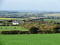
Fields on the island with the coast of Great Britain in the background

See also
 In Spanish: Isla de Wight para niños
