
Isle of Wight County, Virginia facts for kids
Quick facts for kids
Isle of Wight County
|
|||
|---|---|---|---|

Isle of Wight Courthouse and Confederate Monument (removed May 8, 2021).
|
|||
|
|||

Location within the U.S. state of Virginia
|
|||
 Virginia's location within the U.S. |
|||
| Country | |||
| State | |||
| Founded | 1637 | ||
| Named for | Isle of Wight, England | ||
| Seat | Isle of Wight | ||
| Largest town | Smithfield | ||
| Area | |||
| • Total | 363 sq mi (940 km2) | ||
| • Land | 316 sq mi (820 km2) | ||
| • Water | 47 sq mi (120 km2) 13.0% | ||
| Population
(2020)
|
|||
| • Total | 38,606 | ||
| • Density | 106.35/sq mi (41.06/km2) | ||
| Time zone | UTC−5 (Eastern) | ||
| • Summer (DST) | UTC−4 (EDT) | ||
| Congressional district | 2nd | ||


Isle of Wight County is a county in the Hampton Roads area of Virginia, a state in the United States. It got its name from the Isle of Wight, an island in England. Many of the first settlers here came from that English island. In 2020, about 38,606 people lived in Isle of Wight County. The main government center, called the county seat, is in a community also named Isle of Wight.
Isle of Wight County is part of a larger group of cities and towns that includes Virginia Beach, Norfolk, and Newport News. Its northeastern side touches the waters of Hampton Roads.
The county has two official towns: Smithfield and Windsor. The very first courthouse for the county was built in Smithfield in 1750. This old courthouse and a nearby inn (The Smithfield Inn) are still standing today!
Later, around 1800, leaders decided to build a new courthouse closer to the center of the county. This brick courthouse and another inn, Boykin's Tavern, are also still around. Even the clerk's offices from 1822 are still there. The 1800 courthouse is still used for county meetings. A brand new courthouse opened in 2010, right across the street from the sheriff's office.
Contents
History of Isle of Wight County
In the 1600s, soon after the Jamestown settlement began in 1607, English settlers started exploring and moving into the areas near the big Hampton Roads waterway. In 1608, Captain John Smith crossed the James River. He traded with the Native American people, called the Warrosquyoack or Warraskoyak, and got corn from them. This tribe was part of the Powhatan Confederacy and had three villages where Smithfield is now.
The English settlers forced the Warraskoyak people from their villages in 1622 and 1627. This happened after the Native Americans attacked English settlements in 1622, trying to make them leave.
The first English farms, called plantations, in what is now Isle of Wight County were started by Puritan colonists. Christopher Lawne began his farm in 1618, and Edward Bennett (colonist) started his in 1621. Edward's nephew, Richard Bennett, also settled here. He later led the Puritans to a nearby area and became the governor of the Virginia Colony.
By 1634, the whole Virginia Colony had eight shires, or counties, with about 5,000 people. In 1637, Warrosquyoake Shire was renamed Isle of Wight County. It was named after the island off the coast of England. The original name came from the Native Americans of the area.
In 1673, the "Grand Assembly" in Jamestown allowed both Isle of Wight County and Lower Norfolk County to build a fort for protection.
St. Luke's Church, built in the 1600s, is the oldest church building in Virginia. It's considered a very important historical site. Many other historic buildings in Smithfield are also listed on the National Register of Historic Places, like the Wentworth-Grinnan House.
Over time, parts of Isle of Wight County were used to create other counties. In 1732, a large part was added to Brunswick County. In 1748, the entire county of Southampton was formed from Isle of Wight County.
During the American Civil War, a group of soldiers from the county was called the "Isle of Wight Avengers." They were part of the 61st Virginia Infantry Regiment in the Confederate Army.
Geography and Nature
Isle of Wight County covers about 363 square miles. Most of this area, about 316 square miles, is land. The remaining 47 square miles, or 13%, is water.
The James River forms the northern border of the county, and the Blackwater River is to the south. The land is mostly flat and low, with many swamps and wet areas called pocosins.
Neighboring Areas
Isle of Wight County shares borders with these places:
- Newport News, Virginia — to the northeast
- Suffolk, Virginia — to the southeast
- Southampton County — to the west
- Franklin, Virginia — to the southwest
- Surry County — to the northwest
Main Roads
Important roads that run through Isle of Wight County include:
 US 17
US 17 US 258
 US 460
 SR 10
SR 10 SR 32
SR 32
Population Changes
| Historical population | |||
|---|---|---|---|
| Census | Pop. | %± | |
| 1790 | 9,028 | — | |
| 1800 | 9,342 | 3.5% | |
| 1810 | 9,186 | −1.7% | |
| 1820 | 10,139 | 10.4% | |
| 1830 | 10,517 | 3.7% | |
| 1840 | 9,972 | −5.2% | |
| 1850 | 9,353 | −6.2% | |
| 1860 | 9,977 | 6.7% | |
| 1870 | 8,320 | −16.6% | |
| 1880 | 10,572 | 27.1% | |
| 1890 | 11,313 | 7.0% | |
| 1900 | 13,102 | 15.8% | |
| 1910 | 14,929 | 13.9% | |
| 1920 | 14,433 | −3.3% | |
| 1930 | 13,409 | −7.1% | |
| 1940 | 13,381 | −0.2% | |
| 1950 | 14,906 | 11.4% | |
| 1960 | 17,164 | 15.1% | |
| 1970 | 18,285 | 6.5% | |
| 1980 | 21,603 | 18.1% | |
| 1990 | 25,503 | 18.1% | |
| 2000 | 29,728 | 16.6% | |
| 2010 | 35,270 | 18.6% | |
| 2020 | 38,606 | 9.5% | |
| U.S. Decennial Census 1790-1960 1900-1990 1990-2000 2010-2020 |
|||
The population of Isle of Wight County has grown a lot over the years. In 1790, there were just over 9,000 people. By 2020, the population had grown to more than 38,000 people.
Who Lives Here? (2020 Census)
In 2020, the U.S. Census counted 38,606 people in Isle of Wight County.
- About 68.4% of the people were White.
- About 22.2% were Black or African American.
- About 1% were Asian.
- About 4.3% were of two or more races.
- About 3.1% were Hispanic or Latino (who can be of any race).
Public Services
The Blackwater Regional Library system provides library services to the people living in Isle of Wight County.
Communities in the County
Isle of Wight County has several towns and communities.
Towns
Census-Designated Places
These are areas that are like towns but are not officially incorporated.
- Benns Church
- Camptown
- Carrollton
- Carrsville
- Rushmere
Other Communities
- Battery Park
- Burwell's Bay
- Central Hill
- Comet
- Indika
- Isle of Wight
- Lawson
- Mogart's Beach
- Pons
- Raynor
- Rescue
- Stott
- Walters
- Wills Corner
- Zuni
Images for kids
-
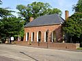
The 1750 courthouse on Main Street in Smithfield.
-
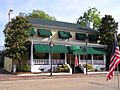
The 1752 tavern on Main Street, now operated as the Smithfield Inn.
-
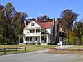
Boykin's Tavern, next to the 1800 courthouse.
-
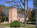
St. Luke's Church, built circa 1632.


See also
 In Spanish: Condado de Isle de Wight para niños
