Rescue, Virginia facts for kids
Quick facts for kids
Rescue, Virginia
|
|
|---|---|
|
Unincorporated community
|
|
| Country | United States |
| State | Virginia |
| County | Isle of Wight |
| Elevation | 20 ft (6 m) |
| Time zone | UTC-5 (Eastern (EST)) |
| • Summer (DST) | UTC-4 (EDT) |
| ZIP code |
23424
|
| Area code(s) | 757, 948 |
| GNIS feature ID | 1493477 |
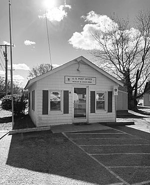
Rescue is a small, special place in Virginia, United States. It's called an "unincorporated community." This means it's a group of homes and businesses that isn't officially a town or city with its own local government. Rescue is located in Isle of Wight County, right by Jones Creek. This creek flows into the big James River. Rescue is about 4 miles (6.4 km) east of a town called Smithfield. It even has its own post office, which opened way back on October 21, 1889.
Contents
The Story of Rescue
Rescue started as a farm that was divided into smaller pieces of land in 1882. Because it was located right on Jones Creek, it quickly became a busy harbor. It was a great spot for watermen who fished and collected oysters.
How Rescue Got Its Name
Jones Creek separates Rescue from nearby Battery Park and Smithfield. There's a fun story about how Rescue got its name! Long ago, mail was delivered to Rescue by a mule. One day, the mule finally arrived in the fishing village with the mail. Someone supposedly yelled that the mail had been "rescued!" And that's how the community got its unique name.
The Important Bridge
For a long time, getting to Smithfield from Rescue was hard. People had to either take a boat or drive a very long way around. But then, the Rescue Bridge was built! This bridge connects Rescue and Battery Park. It made mail delivery much easier and helped people travel to and from Smithfield. The first bridge was built around 1913. This bridge is an important part of Rescue's history.
Life in Rescue Today
Rescue still feels like a friendly, close-knit fishing village. The people who live there want to keep that special feeling alive. In the heart of Rescue, you'll find homes, two marinas (places where boats are kept), a restaurant, and the post office. There's also a building that used to be the old Rescue school, built in 1925. This building later became a community center where local groups met.
Just outside the main part of Rescue, there are two historic churches:
- Riverview United Methodist Church, started in 1887.
- The Friends Church, founded in 1913.
Rescue's Boundaries
The larger area of Rescue starts where Boundary Road and Smith's Neck Road meet. It stretches north and east all the way to the James River. To the west, it reaches Jones Creek. Boundary Road has always been the line that separates Rescue from the Carrollton area. This historic boundary was even used for things like birth certificates and deciding which school district children belonged to. The Jones Creek Boat Landing, found at the end of Boundary Road, is also part of the Rescue community.
 | Janet Taylor Pickett |
 | Synthia Saint James |
 | Howardena Pindell |
 | Faith Ringgold |


