Franklin, Virginia facts for kids
Quick facts for kids
Franklin, Virginia
|
||
|---|---|---|
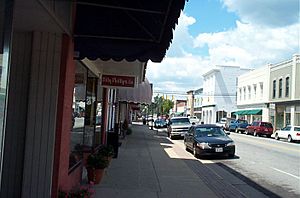
Downtown Franklin, Virginia
|
||
|
||
| Motto(s):
"Growth – Community – Spirit"
|
||
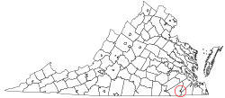
Location in the Commonwealth of Virginia
|
||
| Country | ||
| State | ||
| County | None (Independent city) | |
| Incorporated (Town) | March 1876 | |
| Incorporated (City) | 1961 | |
| Area | ||
| • Total | 8.36 sq mi (21.67 km2) | |
| • Land | 8.28 sq mi (21.44 km2) | |
| • Water | 0.09 sq mi (0.23 km2) | |
| Elevation | 39 ft (12 m) | |
| Population
(2020)
|
||
| • Total | 8,180 | |
| • Density | 978.5/sq mi (377.5/km2) | |
| Time zone | UTC-5 (EST) | |
| • Summer (DST) | UTC-4 (EDT) | |
| ZIP code |
23851
|
|
| Area code(s) | 757, 948 | |
| FIPS code | 51-29600 | |
| GNIS feature ID | 1494943 | |
Franklin is a city in Virginia, located in the southeastern part of the state. It is known as an independent city, which means it is not part of any county. As of the 2020 census, about 8,180 people lived there.
Contents
History of Franklin
Franklin started in the 1830s as a small stop along a railroad line. It was built next to the Blackwater River. The river was important because it helped transport goods to and from North Carolina.
Franklin During the Civil War
In 1862, during the Civil War, a battle happened in Franklin. It was called the Joint Expedition against Franklin. Ships from the U.S. Navy, like the USS Commodore Perry, tried to sail through Franklin on the Blackwater River.
However, a group of Confederate soldiers started shooting at the ships. An officer on one ship described the fighting as being in a "narrow and very crooked stream." Five soldiers died and sixteen were hurt in the battle.
The naval ships had to turn back. The Confederates tried to block the river by cutting down large trees. But they did not succeed in stopping the ships or capturing any soldiers. Seven Medals of Honor were given to brave sailors for their actions in this fight.
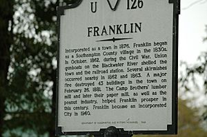
Growth and the Camp Family
Franklin really started to grow in 1887. Six brothers from the Camp family bought a small sawmill next to the Blackwater River. Under the leadership of Paul Douglas Camp, James Leonidas Camp, and Robert Judson Camp, the sawmill grew quickly for 20 years.
In 1890, Franklin became a stop on the Atlantic and Danville Railway. This helped the town grow even more. After some tough times, World War I brought success back to the Camp family's business. By 1918, Franklin was a busy wartime town.
By 1955, the Camp Corporation was making a lot of money, which helped the city of Franklin. The Camp family cared about their community. They paid good wages and gave money to local causes.
In 1956, the Camp Manufacturing Corporation joined with the Union Bag and Paper company. This new company was called the Union Camp Corporation. Franklin continued to grow with Union Camp. In 1961, Franklin officially became an independent city, separate from Southampton County.
Union Camp stayed in Franklin until 1999. Then, a company called International Paper bought it. Even though Union Camp is gone, the Camp family's name is still important in Franklin. You can see their legacy in places like Paul D. Camp Community College, the James L Camp Jr. YMCA, and the Ruth Camp Campbell Memorial Library.
Geography of Franklin
Franklin is located in southeastern Virginia. The Blackwater River forms its eastern border. This river flows south and eventually joins the Chowan River, which flows into Albemarle Sound in North Carolina.
U.S. Route 58 runs along the southern edge of the city. It goes east to Suffolk (about 21 miles) and Norfolk (about 42 miles). To the west, US 58 goes to Emporia (about 35 miles). U.S. Route 258 goes through the middle of Franklin.
The city of Franklin covers about 8.3 square miles. Most of this area is land (8.2 square miles), and a small part is water (0.1 square miles). Isle of Wight County is to the north and east of Franklin. Southampton County is to the north, west, and south.
Franklin's Climate
Franklin has a humid subtropical climate. This means it has hot, humid summers and winters that are usually mild or cool.
| Climate data for Franklin, VA (1991-2020, coordinates:36°40′30″N 76°55′25″W / 36.6751°N 76.9235°W) | |||||||||||||
|---|---|---|---|---|---|---|---|---|---|---|---|---|---|
| Month | Jan | Feb | Mar | Apr | May | Jun | Jul | Aug | Sep | Oct | Nov | Dec | Year |
| Mean daily maximum °F (°C) | 50.9 (10.5) |
54.1 (12.3) |
61.0 (16.1) |
71.3 (21.8) |
78.6 (25.9) |
86.2 (30.1) |
89.9 (32.2) |
88.0 (31.1) |
82.7 (28.2) |
73.2 (22.9) |
62.9 (17.2) |
54.6 (12.6) |
71.1 (21.7) |
| Daily mean °F (°C) | 40.4 (4.7) |
42.8 (6.0) |
49.4 (9.7) |
59.3 (15.2) |
67.7 (19.8) |
75.7 (24.3) |
79.7 (26.5) |
78.0 (25.6) |
72.4 (22.4) |
61.6 (16.4) |
51.0 (10.6) |
43.9 (6.6) |
60.2 (15.7) |
| Mean daily minimum °F (°C) | 29.9 (−1.2) |
31.5 (−0.3) |
37.7 (3.2) |
47.4 (8.6) |
56.7 (13.7) |
65.2 (18.4) |
69.5 (20.8) |
67.9 (19.9) |
62.1 (16.7) |
49.9 (9.9) |
39.0 (3.9) |
33.1 (0.6) |
49.2 (9.5) |
| Average precipitation inches (mm) | 3.69 (94) |
2.83 (72) |
3.97 (101) |
3.57 (91) |
3.91 (99) |
4.61 (117) |
5.34 (136) |
5.40 (137) |
5.45 (138) |
4.08 (104) |
3.22 (82) |
3.58 (91) |
49.65 (1,262) |
| Average dew point °F (°C) | 30.7 (−0.7) |
31.4 (−0.3) |
37.2 (2.9) |
46.5 (8.1) |
57.1 (13.9) |
65.5 (18.6) |
69.8 (21.0) |
68.9 (20.5) |
64.1 (17.8) |
52.8 (11.6) |
41.9 (5.5) |
35.2 (1.8) |
50.1 (10.1) |
| Source: PRISM Climate Group | |||||||||||||
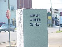
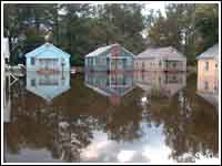
The Blackwater River was important for Franklin's industries. But it has also caused problems, especially flooding. In 1999, after Hurricane Floyd, downtown Franklin was covered in up to 12 feet of water. The river rose to a record high of 26.4 feet. This flood covered 182 businesses and 150 homes. When the name "Floyd" was no longer used for hurricanes, the name "Franklin" was chosen to replace it.
In 2006, Franklin had another big flood. It reached almost the same level as the 1999 flood. This flood happened because a lot of rain fell in the area where the river flows.
People of Franklin (Demographics)
| Historical population | |||
|---|---|---|---|
| Census | Pop. | %± | |
| 1880 | 477 | — | |
| 1890 | 875 | 83.4% | |
| 1900 | 1,143 | 30.6% | |
| 1910 | 2,271 | 98.7% | |
| 1920 | 2,363 | 4.1% | |
| 1930 | 2,930 | 24.0% | |
| 1940 | 3,466 | 18.3% | |
| 1950 | 4,670 | 34.7% | |
| 1960 | 7,264 | 55.5% | |
| 1970 | 6,880 | −5.3% | |
| 1980 | 7,308 | 6.2% | |
| 1990 | 7,864 | 7.6% | |
| 2000 | 8,346 | 6.1% | |
| 2010 | 8,582 | 2.8% | |
| 2020 | 8,180 | −4.7% | |
| U.S. Decennial Census 1790-1960 1900-1990 1990-2000 2010-2013 |
|||
2020 Census Information
The 2020 census counted 8,180 people in Franklin. The table below shows the different racial and ethnic groups living in the city.
| Race / Ethnicity (NH = Non-Hispanic) | Pop 2010 | Pop 2020 | % 2010 | % 2020 |
|---|---|---|---|---|
| White alone (NH) | 3,333 | 2,966 | 38.84% | 36.26% |
| Black or African American alone (NH) | 4,867 | 4,610 | 56.71% | 56.36% |
| Native American or Alaska Native alone (NH) | 27 | 25 | 0.31% | 0.31% |
| Asian alone (NH) | 63 | 81 | 0.73% | 0.99% |
| Pacific Islander alone (NH) | 2 | 2 | 0.02% | 0.02% |
| Other race alone (NH) | 8 | 16 | 0.09% | 0.20% |
| Mixed race or Multiracial (NH) | 141 | 262 | 1.64% | 3.20% |
| Hispanic or Latino (any race) | 141 | 218 | 1.64% | 2.67% |
| Total | 8,582 | 8,180 | 100.00% | 100.00% |
2010 Census Information
In 2010, there were 8,582 people living in Franklin. There were 3,384 households, which are groups of people living together. About 2,277 of these were families.
The city's population was made up of different groups. About 56.9% were Black or African American. About 39.4% were White. Other groups included Asian, Native American, and people of two or more races. About 1.6% of the people were Hispanic or Latino.
About 30.1% of households had children under 18 living with them. The average household had 2.39 people. The average family had 2.93 people.
The median age in the city was 40 years old. This means half the people were older than 40 and half were younger. About 25.1% of the population was under 18. About 18.4% were 65 or older.
The median income for a household was $31,687. This is the middle income for all households. For families, the median income was $40,299. About 19.8% of the population lived below the poverty line. This included 34.9% of children under 18.
Franklin's Economy
Today, Franklin's economy relies on two main areas: farming and making things (manufacturing). Franklin is one of the most profitable farming communities in Virginia. The areas around Franklin, like Southampton and Isle of Wight counties, are also big farming areas.
The manufacturing sector grew when the Camp Lumber Mill opened in 1887. This mill became the Union Camp Corporation, which was later bought by International Paper. The International Paper mill is still in Franklin. It makes lumber, paper products, and other chemicals.
In 2009, International Paper announced that the paper mill would close. This happened in May 2010 and meant about 1,100 people lost their jobs. However, the mill later started making some products again, like fluff pulp. This created 213 new jobs for the community.
Arts and Culture in Franklin
Arts and Museums
Franklin has a small museum about firefighting at the Franklin Fire Department. The city also has the Ruth Camp Campbell Memorial Library, which is part of the Blackwater Regional Library system.
Events and Festivals
Franklin hosts many fun events each year. These include the Lumberjack Festival and the Juneteenth Cultural Celebration. In the fall, there is the Franklin Fall Festival and the Downtown Boo Bash. During the holidays, people enjoy the Franklin Christmas Parade and the Holiday Open House & Craft Fair.
Buildings and History
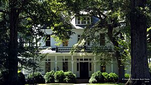
The Franklin Depot & Visitors Center used to be the city's train station. It has been restored and is now in Historic Downtown Franklin. The Elms is a beautiful old house built in 1898. It is known for its Queen Anne and Colonial Revival styles. It is listed on the National Register of Historic Places.
The Franklin Historic District has 226 historic homes and businesses. These include the Camp Family Homestead from around 1840 and the Pretlow Peanut Company Warehouses.
Sports in Franklin
Franklin High School is known for its football team. They won the VHSL Division 1A State Football Championship in 2004 and 2008.
Franklin City Schools also has a FIRST Robotics Competition Team 1610. This team won the NASA/VCU regional robotics competition in 2006. They also won the Virginia regional competition in 2013, 2014, and 2015.
Parks and Recreation
The Franklin Department of Parks & Recreation manages eleven different sites. These include Barrett's Landing on the Blackwater River and the Blackwater River Boat Landing. These places have boat ramps for fishing and boating. The James L. Camp Jr. YMCA is also located in Franklin.
Education in Franklin
Franklin City Public Schools has several schools:
- S. P. Morton Elementary School (Pre-K through 5th grade)
- J. P. King, Jr. Middle School (6th through 8th grade)
- Franklin High School (9th through 12th grade)
Paul D. Camp Community College is also located in Franklin. It offers higher education programs.
City Services (Infrastructure)
Transportation
Air Travel
The Franklin Municipal Airport (John Beverly Rose Field) is located in Franklin.
Healthcare
The Bon Secours - Southampton Medical Center is a hospital in Franklin. It has 221 beds for patients.
Utilities
Franklin Municipal Power and Light provides electricity for the city.
Famous People from Franklin
- Randy Blythe (born 1971), a musician in the band Lamb of God (band)
- Terry Bradshaw, a professional baseball coach
- James Leonidas Camp, one of the founders of the Camp Manufacturing Company (later Union Camp)
- Paul Douglas Camp, one of the founders and president of the Camp Manufacturing Company
- Robert Judson Camp, one of the founders and secretary/treasurer of the Camp Manufacturing Company
- Colgate Darden (1897-1981), a politician and president of the University of Virginia
- Della Irving Hayden (1851-1924), a journalist, teacher, and social worker who founded the Franklin Normal and Industrial Institute
- Joseph Holland, an actor for stage and screen
- Richard Hudson, a congressman
- Charlie Peete (1929-1956), a baseball player
- Randolph Scott, a famous film actor
- Greg Scott (born 1979), a professional football player
- B. Scott, a television personality and internet celebrity
- Charlie Whitehead, a soul singer
See also
 In Spanish: Franklin (Virginia) para niños
 | Madam C. J. Walker |
 | Janet Emerson Bashen |
 | Annie Turnbo Malone |
 | Maggie L. Walker |


