
Franklin, West Virginia facts for kids
Quick facts for kids
Franklin, West Virginia
|
||
|---|---|---|

Pendleton County Courthouse in Franklin
|
||
|
||
| Nickname(s):
F-Town
|
||

Location of Franklin in Pendleton County, West Virginia.
|
||
| Country | United States | |
| State | West Virginia | |
| County | Pendleton | |
| Area | ||
| • Total | 0.56 sq mi (1.46 km2) | |
| • Land | 0.56 sq mi (1.46 km2) | |
| • Water | 0.00 sq mi (0.00 km2) | |
| Elevation | 1,732 ft (528 m) | |
| Population
(2020)
|
||
| • Total | 486 | |
| • Estimate
(2021)
|
482 | |
| • Density | 1,142.35/sq mi (440.93/km2) | |
| Time zone | UTC-5 (Eastern (EST)) | |
| • Summer (DST) | UTC-4 (EDT) | |
| ZIP code |
26807
|
|
| Area code(s) | 304 | |
| FIPS code | 54-29044 | |
| GNIS feature ID | 1551175 | |
| Website | https://www.townfranklinwv.com/ | |

Franklin is a small town in West Virginia, United States. It is the main town, or county seat, of Pendleton County. In 2020, about 486 people lived there. Franklin was founded in 1794 and got its name from an early settler named Francis Evick.
Contents
History of Franklin
Franklin is located in the Allegheny Mountains, near the Monongahela National Forest. It sits along the South Branch of the Potomac River. Native American groups lived in this area for many centuries before English settlers arrived in the mid-1700s.
During the French and Indian War, there were battles between settlers and Native Americans in 1758. These battles happened near Upper Tract and Fort Seybert, which are about ten miles from where Franklin is today. The land for Franklin was first claimed by brothers Francis and George Evick in 1769.
Becoming the County Seat
Pendleton County was formed in 1787 from parts of other counties in Virginia. At first, court meetings were held at Captain Zeruiah Stratton's home. Around 1789, Francis Evick offered some of his land to create a county seat. More land was divided from Evick's property to form the new town.
On December 19, 1794, the Virginia General Assembly officially made Franklin a town. It was recognized as the main town for Pendleton County. Franklin grew steadily in the early 1800s. It became a local hub for businesses and different types of work. By 1834, the town had many skilled workers, like shoemakers, blacksmiths, and carpenters.
The Civil War and Beyond
When the American Civil War started in 1861, Pendleton County chose to support Virginia, even though many residents supported the Union. There were small fights between Union and Confederate soldiers throughout the war.
A major battle near Franklin happened in May 1862. Confederate General Thomas J. "Stonewall" Jackson led his Valley Campaign. He wanted to distract the Union Army from their push towards Richmond, the Confederate capital. On May 8, 1862, Jackson's forces fought Union soldiers at the Battle of McDowell, about 30 miles from Franklin. After the battle, the Union forces retreated towards Franklin. Jackson followed them for almost a week. The armies had a brief clash at McCoy's Mill, just south of Franklin. However, Jackson soon returned to the Shenandoah Valley to continue his campaign.
Franklin did not grow much right after the Civil War. But in the early 1900s, things changed. In 1917, the town's borders expanded, streets were paved, and public water and electricity were added.
Disasters and Rebuilding
On April 17, 1924, a huge fire destroyed the entire business area of Franklin. It caused about $500,000 in damage, which would be around $6.5 million today. Most of the town's center, including its shops and the Pendleton County Courthouse, were rebuilt after this fire.
Another disaster hit Franklin in 1985. The South Branch of the Potomac River flooded badly during the 1985 Election day floods. The river rose to 22.6 feet, much higher than its normal flood level of 7 feet.
Geography and Climate
Franklin is located at coordinates 38°38′51″N 79°19′54″W / 38.64750°N 79.33167°W.
The United States Census Bureau says the town covers about 0.56 square miles (1.46 square kilometers), and all of it is land.
Climate in Franklin
The weather in Franklin has mild changes between high and low temperatures. There is also enough rainfall throughout the year.
| Climate data for Franklin, WV (1991-2020 normals, coordinates:38°40′32″N 79°18′33″W / 38.6756°N 79.3092°W | |||||||||||||
|---|---|---|---|---|---|---|---|---|---|---|---|---|---|
| Month | Jan | Feb | Mar | Apr | May | Jun | Jul | Aug | Sep | Oct | Nov | Dec | Year |
| Mean daily maximum °F (°C) | 43.3 (6.3) |
46.6 (8.1) |
55.3 (12.9) |
66.8 (19.3) |
74.1 (23.4) |
81.1 (27.3) |
84.3 (29.1) |
82.7 (28.2) |
76.8 (24.9) |
67.7 (19.8) |
55.7 (13.2) |
46.4 (8.0) |
65.1 (18.4) |
| Daily mean °F (°C) | 32.5 (0.3) |
34.6 (1.4) |
42.6 (5.9) |
52.4 (11.3) |
60.9 (16.1) |
68.1 (20.1) |
71.8 (22.1) |
70.4 (21.3) |
64.1 (17.8) |
54.2 (12.3) |
43.7 (6.5) |
35.8 (2.1) |
52.6 (11.4) |
| Mean daily minimum °F (°C) | 21.8 (−5.7) |
22.7 (−5.2) |
29.9 (−1.2) |
38.0 (3.3) |
47.7 (8.7) |
55.2 (12.9) |
59.3 (15.2) |
58.1 (14.5) |
51.4 (10.8) |
40.7 (4.8) |
31.6 (−0.2) |
25.1 (−3.8) |
40.1 (4.5) |
| Average precipitation inches (mm) | 2.47 (63) |
2.06 (52) |
3.22 (82) |
3.36 (85) |
4.22 (107) |
3.44 (87) |
4.84 (123) |
3.54 (90) |
3.84 (98) |
2.55 (65) |
2.36 (60) |
2.56 (65) |
38.46 (977) |
| Average snowfall inches (cm) | 8.1 (21) |
8.1 (21) |
3.5 (8.9) |
0.0 (0.0) |
0.0 (0.0) |
0.0 (0.0) |
0.0 (0.0) |
0.0 (0.0) |
0.0 (0.0) |
0.0 (0.0) |
1.2 (3.0) |
5.8 (15) |
26.7 (68.9) |
| Average precipitation days (≥ 0.01 in) | 8.6 | 7.3 | 10.4 | 10.2 | 12.6 | 10.6 | 10.5 | 9.4 | 8.4 | 6.2 | 7.5 | 8.8 | 110.5 |
| Average snowy days (≥ 0.01 in) | 2.1 | 2.6 | 1.5 | 0 | 0 | 0 | 0 | 0 | 0 | 0 | 0.5 | 1.9 | 8.6 |
Fun Things to Do in Franklin
Besides its historical spots, Franklin and Pendleton County offer many places for outdoor fun. Franklin Gorge is a popular place for rock climbing. Franklin is also close to some of West Virginia's most famous state and national parks, like Seneca Rocks, Spruce Knob, and Smoke Hole Canyon.
Population Facts
| Historical population | |||
|---|---|---|---|
| Census | Pop. | %± | |
| 1880 | 273 | — | |
| 1900 | 205 | — | |
| 1910 | 200 | −2.4% | |
| 1920 | 320 | 60.0% | |
| 1930 | 431 | 34.7% | |
| 1940 | 613 | 42.2% | |
| 1950 | 777 | 26.8% | |
| 1960 | 758 | −2.4% | |
| 1970 | 695 | −8.3% | |
| 1980 | 780 | 12.2% | |
| 1990 | 914 | 17.2% | |
| 2000 | 797 | −12.8% | |
| 2010 | 721 | −9.5% | |
| 2020 | 486 | −32.6% | |
| 2021 (est.) | 482 | −33.1% | |
| U.S. Decennial Census | |||
Franklin's Population in 2010
In 2010, the census showed that 721 people lived in Franklin. There were 313 households, and 173 of them were families. The town had about 1287.5 people per square mile.
Most of the people living in Franklin were White (96.5%). A small number were African American (1.0%), Native American (0.6%), or Asian (0.4%). About 0.7% of the population was Hispanic or Latino.
The average age in Franklin was 55.5 years old. About 14.4% of residents were under 18. Many residents, 36.2%, were 65 years or older. The town had more females (55.8%) than males (44.2%).
Arts and Culture
Festivals in Franklin
Franklin hosts two popular festivals each year. The Treasure Mountain Festival happens every third weekend in September. The annual Trout Fest takes place in May. Both festivals bring many visitors from nearby areas.
Historic Buildings and Sites
Much of Franklin's town center is part of the Franklin Historic District. This area was added to the National Register of Historic Places in 1986.
- Bank of Franklin (1925) This building was constructed after the 1924 fire. It was built in a Neoclassical style. The bank closed in 1933.
- Dr. Preston Boggs House (1900) This house on North Main Street was built around 1900. It shows an elaborate Queen Anne Style. It has an octagonal tower and several bay windows.
- Ernest Bowman House (1900) Next to the Dr. Preston Boggs House, this home also shows Queen Anne Style. It has unique porches and projecting sections.
- Franklin Presbyterian Church (1922) The Presbyterian Church in Franklin was started in 1866. The current church building began construction in 1918. It was designed in a Gothic Revival style.
- Franklin United Methodist Church (1881) This church was built in 1881. It combines elements of Gothic Revival and Italianate styles.
- McCoy House (1848) This house was built in 1848 for William McCoy, a local leader. It is a two-story brick house with a Greek Revival Style porch. It was added to the National Register of Historic Places in 1996.
- Johnson House and Drug Store (1878) This brick building on Main Street housed the Johnson family and their drug store for many years.
- Pendleton County Courthouse (1925) Franklin has had four courthouses. The current one was finished in 1925 after the previous one was destroyed by the 1924 fire. It was designed in a Colonial Revival Style.
- The Ananias Pitsenbarger Farm and the Priest Mill are also listed on the National Register of Historic Places.
Getting Around Franklin
Getting to and from Franklin mainly involves using two-lane roads that wind through the mountains. U.S. Route 33 is the main road going east and west through Franklin. U.S. Route 220 is the main road going north and south. Both roads run together for a short part on the north side of town.
Images for kids
-
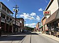
Main Street in downtown Franklin
-
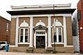
Bank of Franklin
-

Dr. Preston Boggs House
-
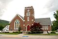
Franklin Presbyterian Church
-
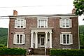
McCoy House
-
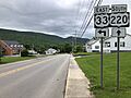
US 33 eastbound and US 220 southbound in Franklin
_just_south_of_Pine_Street_in_Franklin,_Pendleton_County,_West_Virginia.jpg)


_at_Crigler_Lane_in_Franklin,_Pendleton_County,_West_Virginia.jpg)
See also
 In Spanish: Franklin (Virginia Occidental) para niños
