
Smoke Hole Canyon facts for kids
Quick facts for kids Smoke Hole Canyon |
|
|---|---|

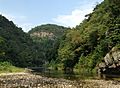
View of Smoke Hole Canyon from atop Cave Mountain. Visible are the South Branch Potomac River and the Big Bend (bottom), as well as Castle Rock and North Fork Gap (distance).
|
|

Smoke Hole Canyon
Location in West Virginia
|
|
| Floor elevation | 1,100 feet (300 m) |
| Length | 20.7 miles (33.3 km) |
| Geography | |
| Rivers | South Branch Potomac River |
Smoke Hole Canyon is a wild and beautiful gorge in eastern West Virginia, United States. It's about 20 miles (32 km) long and was carved by the South Branch Potomac River. This area is quite remote, meaning some parts can only be reached by boat or by walking.
The Canyon is bordered by Cave Mountain to the east and North Fork Mountain to the west. Since 1965, much of Smoke Hole has been part of the Monongahela National Forest's Spruce Knob-Seneca Rocks National Recreation Area. Some land here is still privately owned. Long ago, families lived in this isolated area, known for their traditional ways of life. Today, The Nature Conservancy sees Smoke Hole as "one of the most biologically rich places in the East." It's especially important for its rare plants.
Contents
Exploring Smoke Hole Canyon
Smoke Hole is located in southern Grant and northern Pendleton Counties. The Canyon can be over 1,000 feet (300 m) deep in some places, with very steep walls. The riverbed is about 1,100 feet (340 m) above sea level. You can see amazing views of the Canyon from the 24-mile (39 km) long North Fork Mountain Trail. This trail is to the west and has unique grassy areas called sods and cedar barrens.
Caves are common in the Canyon's slopes. Some of these caves are home to the endangered Virginia big-eared bat. Because these bats need quiet places to rest or hibernate, some caves are closed to visitors during certain times of the year.
The main way to enter Smoke Hole is from the south. You go through a water gap between Big Mountain and Cave Mountain. This spot is called Cave Mountain Gap. It's a half-mile cut through a high ridge.

Long, long ago, the river's path changed dramatically. This process, called "river piracy", caused the river to cut through the land, forming the Smoke Hole gorge we see today. The area has a special type of landscape called karst topography, which means there are many caves and sinkholes.
Near the entrance, the river flows through a narrow channel with fast-moving water known as the "Rock Break." Close by is Big Spring, which provides water for the community of Upper Tract. This spring releases 1,040 gallons of water every minute! High above the river, you can see impressive limestone cliffs called the Cave Mountain Anticline. Another famous rock formation here is Eagle Rock.
About two miles downstream, the river splits around Hermit Island. This island was once a popular spot for picnics. Further down the river, you'll find Fishing Rock and Fishing Rock Ford. About 3.8 miles from the entrance, you reach an area that was once the center of the "town of Smoke Hole." Here, you'll find Shreve's Store, the Smoke Hole Campground, and the old Palestine Church.

From Shreve's Store, a road continues north along the river for about two miles to the old town of Ketterman. The road ends about a mile further at Big Bend Campground. Big Bend is a unique "peninsula" where the river loops around almost completely.
The South Branch River in the Canyon is joined by several smaller streams. Beyond Big Bend, the Canyon becomes a remote wilderness. It's one of the most isolated parts of the state. You can only explore it on foot or by boat. Famous rock formations in this wild section include Indian House Cave, Castle Rock, Blue Rock, and Bulls Head.
A Look Back in Time
Early Settlers and Life
The first settlers arrived in Smoke Hole in the 1750s. One of the first was a man named Steele. His daughter, Katie, had the first wedding in the Canyon. Another daughter, Susie, sadly died after an encounter with Native Americans. Her father buried her on a small hill now called "Susie Hill."
Early families like the Steeles, Fulls, and Eagles lived by smallholder farming. They also hunted and fished. In those days, animals like bison and elk roamed the area. They raised livestock and gathered wild foods like huckleberries and chestnuts. They also collected maple sugar and wild honey. Because the community was so hard to reach, they rarely sold their crops in nearby towns.
The name "Smoke Hole" has a few stories. One popular idea is that Native Americans used a cave in the gorge (Smoke Hole Cave) to smoke meat. This cave has a special room where smoke could escape through a hole at the top, making it look like a "smoke hole." Another idea is that a misty fog often hangs over the river, looking like smoke. A third story suggests the name came from the fires of homemade liquor stills. However, long-time residents say the Native American "smoke house" cave story is the oldest and most likely true.

The 1800s
Later, more families like the Kimbles and Kettermans settled in Smoke Hole. A log church, Palestine Church, was built around 1850.
A large cave on Cave Mountain, now called Cave Mountain Cave, was important for making gunpowder. People mined a mineral called saltpeter there from early times, including during the War of 1812 and the American Civil War. During the Civil War, local people, including those too old or young to fight, were made to work in the mine. Union supporters, known as "Swamp Dragons," later destroyed the mining operations. Most Smoke Hole settlers did not own slaves and supported the Union during the war.
Life in the Early 1900s
In the early 1900s, Smoke Hole was known for being very isolated. Many stories were told about the people living there. Homemade liquor was a common product, made for local use and also shared with people far away. Federal officers sometimes destroyed the equipment used to make it. Despite the wild stories, there is no proof that any officers were ever harmed in Smoke Hole.
In 1927, the Monongahela National Forest expanded to include Smoke Hole. By 1930, the first improved road reached the southern part of the gorge. The Civilian Conservation Corps helped build a recreation area here between 1934 and 1936. In 1936, a big flood washed away their camp. At this time, children went to a local one-room schoolhouse. If they wanted to go to high school, they had to walk seven miles each way to catch a bus!

During the Great Depression, many people left the Canyon to find work. By 1941, about 300 people lived in the area. But World War II caused even more people to move away. Today, many of the old mountain roads that connected homes are no longer used. Electricity and gas only reached the few remaining residents in 1949.
Protecting and Enjoying the Canyon
In 1965, much of Smoke Hole became part of the Spruce Knob-Seneca Rocks National Recreation Area. A hotel called the Smoke Hole Lodge operated here until a flood damaged it in 1985.
The Nature Conservancy is working to protect the Smoke Hole region. In 2004, they bought land to help preserve it. The Monongahela National Forest also set aside over 3,000 acres (1,200 ha) for quiet recreation and wildlife.
In 2013, a large wildfire, the biggest in the Monongahela National Forest since the 1950s, burned over 1,600 acres in Smoke Hole. Firefighters from many states worked for 12 days to put it out.
The Canyon is also a great place for whitewater paddling, especially in the spring when the water is high.
Nature in Smoke Hole
Smoke Hole is a very diverse natural area. It has a special type of forest that grows on limestone soil. Most forest soils in West Virginia are acidic, but limestone soil is different. It's richer in certain nutrients, so it supports unique plants. You can find common Appalachian plants mixed with prairie plants like prairie rocket and Indian grass.
The dry, prairie-like areas on the Canyon's ridges are home to plants usually found in the western United States, like prairie flax. Smoke Hole gets less rain than usual, which helps these special plants grow. About a dozen plant and animal species in Smoke Hole Canyon are considered "globally rare."
Plants of the Canyon

Trees
The main trees on the Canyon's slopes are oak, black walnut, ash, mulberry, and hickory. You'll also see ironwood, linden, flowering dogwood, eastern redcedar, birch, aspen, American beech, tulip poplar, and six kinds of pine. The common pawpaw tree, with its tasty fruit, grows abundantly near the river.
Shrubs
Under the trees, you'll find shrubs like huckleberry, blackberry, raspberry, teaberry, and wild grape. Other plants include crab-apple, witch hazel, rhododendron, and honeysuckle.
Wild Flowers and Herbs
A botanist once found 283 different plant species on Hermit Island alone! In spring, you'll see bloodroot and yellow dog-toothed violets. Later, Spring beauties, bluets, and dandelions appear. Summer brings jack-in-the-pulpit, trilliums, wild roses, lady slippers, and black-eyed susans.
The prairie-like areas in Smoke Hole are the largest of their kind in the Central Appalachians. They are home to rare plants found nowhere else nearby. The Smoke Hole bergamot, a type of mint, grows in only a few places in the world, and Smoke Hole is one of them. Virginia nailwort is another very rare plant found on the Canyon walls.
Animals of the Canyon
Mammals
Long ago, bison, elk, and cougar lived here, but they are gone now. White-tail deer were also gone but were brought back in the 1940s and are now thriving.
Today, Smoke Hole has many black bears and bobcats. It's also known for its large number of timber rattlesnakes, which are rare elsewhere. Smaller animals include red and grey foxes, raccoons, opossums, beavers, wild turkeys, and squirrels. Coyotes have also returned recently.
The Allegheny woodrat, which lives in rocky areas, is facing challenges due to a roundworm problem. The Canyon is very important for bats. It's home to about 40 percent of the world's Virginia big-eared bat population and the largest group of Indiana bats, both of which are endangered. Their caves are protected during important times of the year.
Birds
Smoke Hole is a great place for birds that fly south for the winter, like Wood thrushes and scarlet tanagers. These birds find a safe home in the secluded Canyon. You can also see Bald eagles nesting and great blue herons hunting by the river. Other birds include robins, cardinals, kingfishers, and various owls and hawks.
Other Wildlife
The South Branch River in Smoke Hole has rainbow trout, black and rock bass, and eels. Many kinds of frogs live here, including wood, bronze, and leopard frogs.
Rare butterflies, like the columbine duskywing, live in the Canyon's grassy, limestone areas. A special type of tiger beetle lives in the sandy areas along the riverbanks.
Invading Species
Some plants and insects that are not native to Smoke Hole are causing problems. An Asian grass called Japanese stiltgrass was accidentally brought to the U.S. and has spread widely in the Canyon. It covers the ground and prevents other native plants from growing.
Another threat is the hemlock woolly adelgid, an insect from Asia that attacks eastern hemlock trees. It coats and kills the tree branches. The Forest Service and The Nature Conservancy are working to stop the spread of both the stiltgrass and the adelgid. They are even considering bringing in an Asian beetle that eats the adelgid to help.
Two other non-native plants, spotted knapweed and viper's bugloss, also threaten the Canyon's rare plant communities.
Fun in Smoke Hole

Smoke Hole Canyon is a fantastic place for outdoor activities! You can go fishing for rainbow and golden trout, and largemouth and smallmouth bass. Hunting for squirrel, turkey, deer, and bear is also popular. Many people enjoy hiking, rock climbing, caving, canoeing, and camping.
Boating Adventures
Kayaking and whitewater canoeing are excellent ways to explore the Canyon, especially the lower parts where there are no roads. The entire river trip from US 220 to Petersburg is about 25 miles (40 km) long. The difficulty of the rapids ranges from easy (Class I) to challenging (Class III+).
Camping Spots
Big Bend Campground is located on a peninsula in the river. It has 46 campsites with hot and cold water and flush toilets available from April 15 to October 1. Hot showers are also provided. You can also find group camping at the Jess Judy Camping Area along the river.
Hiking Trails
The main trail inside the Smoke Hole gorge is the 3.5-mile South Branch Trail. This loop trail starts at a picnic area and follows the river upstream. It then goes up Cave Mountain, passes old farms, and returns to the river.
For a longer hike, the 24-mile (39 km) long North Fork Mountain Trail is amazing. It runs along the top of North Fork Mountain and offers incredible views down into Smoke Hole. You can access this trail from several points along Smoke Hole Road.
Rock Climbing
Smoke Hole Canyon offers many opportunities for rock climbing. You can find climbing spots near the Route 220 entrance, at the soaring Eagle Rocks, and on the steep routes of Sanctuary. There are also miles of cliffs along the west side of North Fork Mountain, which can be reached from trails on the canyon rim.
Images for kids
-
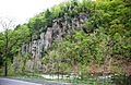
Unnamed cliff (part of the Alt Cabin Anticline) along Smoke Hole Road
-
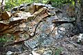
Exposed rock layers near Big Bend Campground
-
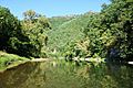
A view of the South Branch at Big Bend
-
Blue Rock, composed of the Late Silurian Tonoloway Formation limestone, in the lower Smoke Hole Canyon
-
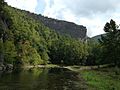
Redman Gap and the South Branch
-
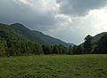
Bottomland in the lower Canyon (looking upstream)
-
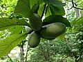
Fruit of common pawpaw (Asimina triloba) in the lower Canyon
-
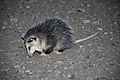
Juvenile Virginia opossum
-
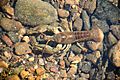
Crayfish in South Branch Potomac River
-
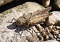
Mating grasshoppers
-
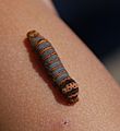
Unidentified caterpillar
-
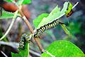
Monarch butterfly caterpillars
-
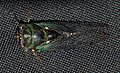
Tibicen cicada
-
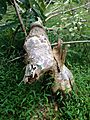
Beaver handiwork in the lower gorge


