
North Fork Mountain facts for kids
Quick facts for kids North Fork Mountain |
|
|---|---|

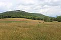
West-facing Tuscarora quartzite cliff along the crest of North Fork Mountain; pine tree in foreground.
|
|
| Highest point | |
| Peak | Kile Knob (Pendleton County, WV) |
| Elevation | 4,588 ft (1,398 m) |
| Dimensions | |
| Length | 34 mi (55 km) |
| Geography | |

Location in West Virginia
|
|
| Country | United States |
| Range coordinates | 38°40′03″N 79°26′16″W / 38.66750°N 79.43778°W |
| Parent range | Allegheny Mountains |
| Topo map | USGS
|
North Fork Mountain is a long mountain ridge in eastern West Virginia, USA. It's known for its cap of tough quartzite rock. This mountain is part of the Allegheny Mountains.
The highest point on North Fork Mountain is Kile Knob, which stands at 4,588 feet (1,398 meters) tall. Other high points include Panther Knob and Pike Knob.
North Fork Mountain is unique because it's one of the driest high mountains in the Appalachian Mountains. This means it has different plants than other nearby, wetter mountains like Spruce Knob. You'll find lots of pine trees on its ridge, unlike the spruce trees common on other high peaks.
The mountain is shaped like a giant upside-down U, a geological feature called an anticline. The hard rock layer that forms the top of the mountain, called Tuscarora quartzite, is mostly flat on top. But on the sides, this same rock layer bends sharply downwards. This creates amazing rock formations like Seneca Rocks.
A big part of North Fork Mountain is inside the Monongahela National Forest. Some areas are protected by The Nature Conservancy, like Panther Knob and Pike Knob. A beautiful path called the North Fork Mountain Trail runs along the top of the ridge. Only one main road, U.S. Route 33, crosses this rugged mountain.
Contents
Mountain Geography
North Fork Mountain stretches about 34 miles (55 kilometers) from northeast to southwest. It runs through Grant and Pendleton Counties in West Virginia. The mountain acts as a natural barrier. It separates the water flowing into the South Branch of the Potomac River from the water flowing into its North Fork.
The mountain begins suddenly near a water gap called North Fork Gap. This gap is where the North Fork river and West Virginia Route 28 pass through. The mountain then continues southwest to Dry Run Gap.
The highest point is Kile Knob, at 4,588 feet (1,398 meters). Other important spots include Panther Knob (4,498 feet) and Pike Knob. These two knobs have nature preserves managed by The Nature Conservancy.
Today, there are no big towns directly on the mountain. However, there are scattered homes and vacation cabins. The main campus for Future Generations Graduate School is also located on the ridgeline. It's near U.S. Route 33, the only major road that crosses the mountain.
Mountain Geology
North Fork Mountain is part of a large geological structure called the Wills Mountain Anticline. This structure stretches from Pennsylvania all the way to Virginia. The same ridge that forms North Fork Mountain is called New Creek Mountain further north.
The top of North Fork Mountain is covered by a very hard rock called Tuscarora quartzite. This rock layer is only about 50 feet (15 meters) thick. It resists erosion, which is why it forms the mountain's ridge. This hard rock often creates wide, slightly tilted slabs. It also forms many west-facing cliffs and large rock formations like Chimney Top. Just west of the mountain, this same quartzite layer stands almost straight up. This creates dramatic cliffs like Seneca Rocks, Champe Rocks, and Nelson Rocks. These vertical cliffs are part of a formation known as the River Knobs.
The lower, western slopes of the mountain have softer rock layers. These layers are easily worn away. This area has many caves, including the famous Hellhole.
Mountain History
For many years, families lived on the eastern side of North Fork Mountain. These early settlers were often called "Smoke Holers." Their community was named after the nearby Smoke Hole Canyon. These families did not own slaves. This meant they supported the Union during the American Civil War. This sometimes led to conflicts with other communities.
The Rohrbaugh Cabin, a log cabin built around 1880, still stands on the eastern slope. Most of the mountain's forests were cut down for timber in the late 1800s and early 1900s.
Much of North Fork Mountain became part of the Monongahela National Forest in 1911. Scientists started studying the plants on Panther Knob in 1926. They were surprised to find plants similar to those in the Pine Barrens of New Jersey.
In the early 1900s, a local person named Cal Nelson lived on the western slopes. "Nelson Sods" and the "Cal Nelson Trail" are named after him.
In March 1930, a huge forest fire swept across North Fork Mountain. It burned for 11 days before rain put it out. This fire led the Forest Service to create a better fire-fighting plan. They hired fire wardens and built a 90-foot steel fire tower on Pike Knob. Local men were recruited to fight fires. However, some locals were unhappy. They felt the fire control hurt their ability to graze animals and gather berries. The last big fire on the mountain was in 1941. Today, you can still see the foundations of the Pike Knob fire tower.
Since the 1980s, The Nature Conservancy has worked to protect habitats on North Fork Mountain. They work with the Forest Service and private landowners. They have also created preserves on Panther Knob and Pike Knob.
Mountain Ecology
Mountain Plants


The forests on North Fork Mountain have many different trees, mostly oaks and other hardwoods. You'll also find mountain laurel, flame azalea, and wintergreen. Pine trees are common along the ridge, especially near the cliffs. The mountain slopes also have many fern beds and wildflowers. Some high-elevation open areas, called mountain meadows, exist, like Nelson Sods.
The rocky cliff edges on the west side of North Fork Mountain have special plants. These include the silvery nailwort and the white alumroot. Chestnut oak and Table Mountain pine often grow near the cliff edges.
Some peaks have "pine barrens," which are areas with many pines that are kept open by frequent fires. Panther Knob has the largest pine barren in the Central Appalachians. Other rocky tops, like Pike Knob, are covered in red pine forests. These are the southernmost natural red pine forests. The Monongahela National Forest has set aside 10 acres (4 hectares) of old growth red pine forest as a special botanical area.
Another unique plant area is an "elfin forest." This forest has small, twisted trees like yellow birch, mountain ash, and mountain holly.
The plants on North Fork Mountain are different from those on nearby mountains to the west. Those mountains get more rain. Their lower slopes have forests with sugar maple, beech, and yellow birch. Higher up, they have red spruce.
The rocky openings on North Fork Mountain are also different from those on mountains like Spruce Knob. North Fork Mountain's hard quartzite breaks down into sand. This sand can form tiny dunes on flat rock surfaces. The mountains to the west have a different type of rock that breaks into gravel. While both areas share some plants, North Fork Mountain has unique species like silvery nailwort and white alumroot.

Rare plants on the mountain include paper birch, butternut, Smoke Hole bergamot, Appalachian oak fern, Allegheny onion, and American chestnut. Pike Knob has red pine stands and rare species like rusty woodsia and the bristly rose. The bristly rose is found here at its southernmost known location.
Panther Knob has the world's largest population of variable sedge. This plant needs fires to grow. You can also find beach heather and Michaux's saxifrage there.
Mountain Animals

North Fork Mountain is home to many animals. These include whitetail deer, wild turkey, black bear, Coyotes, bobcats, and gray foxes. You might also see timber rattlesnakes and eastern newts. Many other birds, mammals, reptiles, and amphibians live here too.
Two species of concern, the peregrine falcon and the Allegheny woodrat, are found on North Fork Mountain. Golden eagles also live in the area. Many rare bat species use nearby limestone caverns for roosting. They often fly over North Fork Mountain's western slopes to find food. The pink-edged sulphur butterfly is found on Panther Knob. Its caterpillars eat blueberries, which grow well there after fires.
Scenery and Recreation
North Fork Mountain offers amazing views to the west. You can see the River Knobs, including Seneca Rocks and Champe Rocks. You can also see the Germany Valley, Spruce Mountain, and Spruce Knob.
From mountains west of the North Fork Valley, like Spruce Knob, you can see North Fork Mountain clearly. Nelson Sods on North Fork Mountain has views of the Roaring Plains and Shenandoah Mountain.
State Route 28 follows the North Fork River. It offers great views of the River Knobs and North Fork Mountain. The Germany Valley Overlook on U.S. 33 also provides wide views. From here, you can see the Germany Valley, the River Knobs, Spruce Mountain, and the cliffs of North Fork Mountain itself.
The North Fork Mountain Trail is 23.8 miles (38.3 kilometers) long. It follows much of the mountain's crest. This trail was once called the best trail in West Virginia by Outside magazine. While hiking is allowed, bikes are not permitted on parts of the trail that cross private land.
Images for kids
-
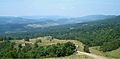
Germany Valley, with North Fork Mountain to the east on right
-
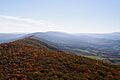
Overview of North Fork Mountain
-
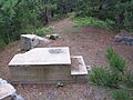
Former Pike Knob Fire Tower footings
-
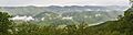
The River Knobs and Nelson Rocks (middle distance) beneath the crest of North Fork Mountain
-
Kile Knob from Goshen Ridge, North Fork Mountain, WV


