
River Knobs (West Virginia) facts for kids
For other "River Knobs", see River Knobs (disambiguation).
Quick facts for kids River Knobs (West Virginia) |
|
|---|---|

The River Knobs around Nelson Rocks
|
|
| Highest point | |
| Elevation | 2,854 ft (870 m) |
| Geography | |
| Location | Pendleton County, West Virginia, U.S. |
| Parent range | Allegheny Mountains, part of the Ridge-and-Valley Appalachians |
| Topo map | USGS ????? |
The River Knobs are a cool set of hills and ridges in western Pendleton County, West Virginia, USA. They used to be called East Seneca Ridge. These unique landforms are found along the North Fork South Branch Potomac River.
Even though the River Knobs are about 2,854 feet high, they are smaller than nearby mountains like Spruce Mountain (4,840 feet) and North Fork Mountain (4,588 feet). What makes the River Knobs special are their sharp, blade-like ridges, often called "razorbacks" or "fins." The most famous of these rock formations is Seneca Rocks.
Contents
Exploring the Geography of River Knobs
The River Knobs stretch for about 18 miles (29 km) from Cherry Grove to Seneca Rocks. They run in a southwest to northeast direction. These ridges are a small part of the Allegheny Mountains, which are themselves part of the larger Appalachian Mountain Range.
Visible Rock Formations and Gaps
You can easily see the rock outcrops of the River Knobs from roads like WV 55 and US 33. Each major rock feature has a named gap where a stream has cut through the ridge. This cutting action reveals the bedrock underneath.
From north to south, here are some of the most important features:
- Roy Gap, home to the famous Seneca Rocks
- Harper Knob, which is 2,820 feet high
- Harper Gap
- Harmon Knob, the highest point at 2,854 feet
- Hinkle Gap
- Germany Knob, at 2,802 feet
- Riverton Gap
- Judy Gap, featuring the Judy Rocks
- Nelson Gap, where you'll find Nelson Rocks
- False Gap
- Lambert Gap
- Pike Gap
- Teter Gap
How the River Knobs Connect to Other Landforms
The River Knobs are part of the same big fold in the Earth's crust. This fold continues north to form Champe Knobs, which include the Champe Rocks and Yellow Rocks. To the south, the fold becomes River Hill and, in Virginia, Lantz Mountain.
Understanding the Geology of River Knobs
The rocks you see at the River Knobs are made of a very strong type of rock called quartzite. Specifically, it's Tuscarora Sandstone, which is an incredibly hard sedimentary rock. Its color can range from almost clear white to gray, pink, or orange.
How the Rocks Were Formed and Tilted
This rock was first laid down as sediment on a sea floor about 440 million years ago. In West Virginia, the Tuscarora Sandstone layer is usually 150 to 250 feet (46 to 76 meters) thick.
About 230 million years ago, during the formation of the Appalachians, powerful geological forces pushed and folded this rock layer. This created enormous arches in the Earth's crust, some miles wide. The River Knobs show the western side of one of these arches, called an anticline. Here, the Tuscarora Sandstone was tilted a full 90 degrees, from flat to standing straight up.
Over a very long time, softer rocks covering this arch wore away due to erosion. Eventually, even the top of the arch eroded. The tough quartzite on the western sides resisted this erosion, leaving behind the tall, narrow, vertical plates of exposed rock that we see today as "fins." About 2 miles (3.2 km) east, on top of North Fork Mountain, you can see the flat layers of the other side of this same Tuscarora anticline.
Germany Valley and Unique Rock Formations
Inside this eroded anticline is Germany Valley. This area is special because of its unique karst topography, which means it has features like caves and sinkholes formed by dissolving bedrock. It's even registered as a National Natural Landmark.
At places like Champe Rocks and Nelson Rocks, you can see not one, but two parallel rock fins. This happened because during the rise of the Appalachians, the same forces that created the arch also caused the Tuscarora rock to break or rupture. The upper layer then slid over and overlapped the lower layer. As the top of the arch wore away, two fins were left behind. Nelson Rocks is a great example of this "faulted Tuscarora" rock.
Seneca Rocks is different. It's a much thicker, single rock formation. Here, the rock didn't break cleanly into two layers. Instead, it rolled over on itself. If you look north from Roy Gap, you can clearly see the curving layers of rock around the large cave at the south end of Seneca Rocks.
Fun Facts About River Knobs
- Nelson Rocks Preserve has a via ferrata, which is a protected climbing route. It's one of only six in North America!
- The preserve also features a cool rope bridge that is 200 feet (61 meters) long and 150 feet (46 meters) high.
Images for kids
-
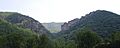
Champe Rocks, at the northern end of the River Knobs
-
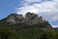
Seneca Rocks
-
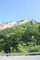
Judy Rocks


