Spruce Mountain (West Virginia) facts for kids
Quick facts for kids Spruce Mountain |
|
|---|---|
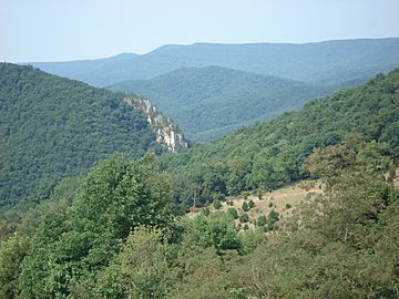
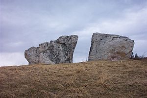
Spruce Mountain (in the distance) beyond the River Knobs (Judy Rocks, foreground) and the Fore Knobs (middle distance)
|
|
| Highest point | |
| Peak | Spruce Knob (Pendleton County, West Virginia) |
| Elevation | 4,863 ft (1,482 m) |
| Dimensions | |
| Length | 16 mi (26 km) approximately |
| Geography | |
| Country | United States |
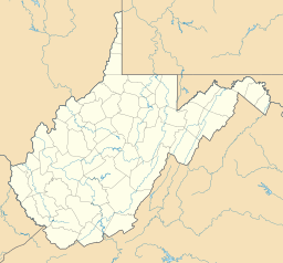
| State | West Virginia |
| County | Pendleton |
| Range coordinates | 38°45′N 79°29′W / 38.750°N 79.483°W |
| Parent range | Allegheny Mountains, part of the Ridge-and-Valley Appalachians |
| Topo map | USGS |
Spruce Mountain is a tall mountain ridge in eastern West Virginia, USA. It's the highest part of the Allegheny Mountains. This ridge looks a bit like a "whale's back" and stretches for about 16 miles (26 km). Many of its peaks are very high, over 4,500 feet (1,372 meters). The very top of Spruce Mountain is called Spruce Knob. It stands at 4,863 feet (1,482 meters) and is the highest point in all of West Virginia! It's also the highest point in the entire Allegheny Mountain range.
Contents
Exploring Spruce Mountain's Location
Spruce Mountain is mostly found within the Spruce Knob-Seneca Rocks National Recreation Area. This special area is part of the Monongahela National Forest (MNF) in Pendleton County. The mountain stretches from a town called Onego in the north down to Cherry Grove in the south.
A smaller ridge called Timber Ridge is to the east, separated by a stream called Brushy Run. North of US Route 33, Spruce Mountain's ridges continue as Hoffman Ridge and Smith Mountain. To the south of West Virginia 28, the line keeps going as Big Mountain.
Tallest Peaks of Spruce Mountain
Several peaks stand out on Spruce Mountain. From north to south, they include:
- Horse Rock (4,536 feet or 1,383 meters)
- Spruce Mountain Peak (4,586 feet or 1,398 meters)
- Picea Benchmark (4,613 feet or 1,406 meters)
- Spruce Knob (4,863 feet or 1,482 meters)
Spruce Knob is the highest point in the eastern United States. It's taller than any other mountain between the Adirondacks in New York and Mount Rogers in southern Virginia.
What the Summit Feels Like
The very top of Spruce Knob feels a lot like an alpine area. This means it's cold and windy, similar to places in northern New England or Canada. The top few hundred feet are covered in a thick spruce forest. These trees are part of a boreal forest environment.
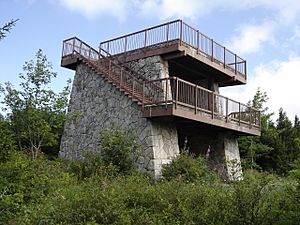
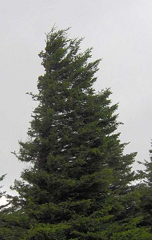
You can reach the summit by trails or a paved road. At the top, there's a stone lookout tower. The area also has big rocks, open grassy spots, and trees. A half-mile (0.8 km) nature trail circles the very top of the mountain. Strong winds near the summit have made the spruce trees look twisted. Their branches only grow on the side away from the wind, which is called flagging.
The highest point on a mountain ridge in the southern Appalachians is often called a "knob" or "dome." Spruce Knob is the highest spot along a ridge known as the Allegheny Front. From the east, it drops steeply, giving great views of the Germany Valley and North Fork Mountain. To the west, you can see the Allegheny Plateau. Spruce Knob is also the highest point in the entire Chesapeake Bay Watershed.
How Spruce Mountain Was Formed (Geology)
Like other parts of the Appalachian Mountains, Spruce Knob began to form a very long time ago. This was when the supercontinent Pangea started to break apart, between 570 and 500 million years ago. The African Plate moved away from the North American Plate, creating the Proto-Atlantic Ocean. The North American Plate stretched, and a shallow inland sea filled the area.
About 50 million years later, during the Taconic Orogeny, the plates started moving towards each other. Volcanoes formed in the middle of the ocean (now the Blue Ridge Mountains). These volcanoes eventually crashed into the North American Plate. This collision pushed up the land to the west.
Over time, shells and other hard parts of sea creatures (made of calcium carbonate) collected at the bottom of the shallow sea. These cemented together to form a layer of Greenbrier Limestone. As the land rose, the sea began to shrink. Fine mud and silt settled, turning into a layer of Mauch Chunk Shale on top of the limestone. As the Blue Ridge Mountains wore down, rivers carried sediment, forming a layer of Pottsville Conglomerate on top of the shale. The large boulders you see on the summit today are pieces of this layer. You can find Mauch Chunk Shale and Greenbrier Limestone lower down the mountain.
Around 250 million years ago, the North American and African Plates finally crashed into each other. This caused a huge uplift that folded and broke these layers of rock. Spruce Knob was originally at the bottom of one of these folds. However, cracks in the Pottsville Conglomerate at higher elevations allowed it to wear away quickly. The softer shale and limestone layers also eroded fast. This left Spruce Knob as the highest point in the area. Spruce Knob is the westernmost place where this intense folding and breaking of rock happened. To the west, the Allegheny Plateau has more gently sloping hills and winding river systems.
Spruce Mountain's Climate
Spruce Knob has a cold continental or highland climate. This means summers are cool and often wet, with thunderstorms common in spring and summer. Winters are cold and snowy. The mountain gets about 180 inches (4.6 meters) of snow each year. This often makes the road to the summit impassable from October to April.
Blizzards can start very quickly when cold fronts move in. They can last for days with heavy snow falling as northwest winds blow. This makes travel on the mountain dangerous in colder months. This mountain can also have strong winds all year round. The red spruce trees are often bent and twisted from being constantly exposed to these strong westerly winds.
Nature and Wildlife (Ecology)
Plants of Spruce Mountain (Flora)
Most of the original forests on Spruce Mountain were cut down by logging around the early 1900s. Today, the forests are mostly second- or third-growth. This means the trees have grown back after being cut down. Only a small 17-acre (6.9-hectare) area on North Spruce Mountain still has old-growth forest.
The current forests on Spruce Mountain have many sugar maple (Acer saccharum), American beech (Fagus grandifolia), and yellow birch (Betula lutea) trees. Other common trees in this mixed forest region include tuliptree (Liriodendron tulipifera), basswood (Tilia species), chestnut (Castanea dentata), yellow buckeye (Aesculus flava), red oak (Quercus borealis), white oak (Q. alba), and eastern hemlock (Tsuga canadensis).
Higher up on Spruce Mountain, you'll find "northern hardwood" and "northern evergreen" forests. Northern hardwood forests have red oak, white ash (Fraxinus americana), basswood (Tilia species), red maple (Acer rubrum), and cherry (Prunus species). The evergreen forests are mostly made up of the mountain's famous red spruce (Picea rubens). While these trees don't grow above the timberline, the strong winds make them stunted and spread out.
The summit was named for the spruce trees that grow there. Red spruce (Picea rubens) is the most common tree species at the top. Lower down, you'll find oak, hickory, birch, beech, and maple trees.
Animals of Spruce Mountain (Fauna)
You might spot amazing birds like bald eagles, hawks, and peregrine falcons on the mountain. Many mammals also live here, including black bears, white-tailed deer, weasels, porcupines, skunks, and rabbits. The mountain is also an important home for ruffed grouse (Bonasa umbellus). Because of this, the MNF created the 1,750-acre (708-hectare) Spruce Mountain Grouse Management Area.
Fun Things to Do (Recreation)
Spruce Knob is located within the Spruce Knob-Seneca Rocks National Recreation Area. This area is part of the Monongahela National Forest. It was the first National Recreation Area created by the U.S. Forest Service in 1965. It covers more than 100,000 acres (40,469 hectares)!
There are over 75 miles (121 km) of hiking trails around the mountain. On the west side of the mountain, there's a small 25-acre (10-hectare) lake. This lake is well-stocked with trout, so it's a great place for fishing. There are also two campgrounds on the mountain. The larger one has 43 sites and is closest to the lake.
Hiking trails like Huckleberry Trail, Lumberjack Trail, and Spruce Mountain Trail run along the ridge.
How to Get There (Access)
You can reach Spruce Knob by paved roads from U.S. Route 33/West Virginia Route 28. This is about 2 miles (3.2 km) south of Riverton. Briery Gap Road (County Route 33/4), Forest Road 112, and Forest Road 104 have all been rebuilt and paved. This gives you a smooth road all the way to the summit.
Keep in mind that Forest Roads 104 and 112 are not kept clear in the winter. You can expect them to be impassable anytime from mid-October to mid-April.
 | Dorothy Vaughan |
 | Charles Henry Turner |
 | Hildrus Poindexter |
 | Henry Cecil McBay |


