
Allegheny Front facts for kids
Quick facts for kids Allegheny Front |
|
|---|---|

Dans Mountain, part of the Allegheny Front in Maryland
|
|
| Highest point | |
| Peak | Mount Porte Crayon (Randolph/Pendleton Co. border, West Virginia) |
| Elevation | 4,774 ft (1,455 m) |
| Geography | |

The Allegheny Front is west of the Cumberland Valley and is part of the Appalachian escarpment extending between the Helderberg Escarpment in New York to Walden Ridge in Tennessee.
|
|
| Country | United States |
| Range coordinates | 39°04′23″N 79°17′53″W / 39.07306°N 79.29806°W |
| Parent range | Allegheny Mountains of the Ridge-and-Valley Appalachians |
| Geology | |
| Orogeny | Alleghenian orogeny |
The Allegheny Front is a big, steep slope or cliff that runs through parts of Pennsylvania, Maryland, and West Virginia in the USA. It's like a natural wall that separates two different parts of the Appalachian Mountains. To its east are the Ridge-and-Valley Appalachians (mountains with many ridges and valleys). To its west is the Appalachian Plateau, which is flatter on top.
This Front is also very close to the Eastern Continental Divide. This is an imaginary line that separates where water flows. Rivers on one side flow towards the Atlantic Ocean. Rivers on the other side flow towards the Ohio River and Mississippi River, eventually reaching the Gulf of Mexico.
The Allegheny Front is one of the windiest places east of the Mississippi River. Because of this, many wind farms have been built there recently to create electricity.

Contents
Exploring the Allegheny Front
The Allegheny Front is a key part of the Appalachian Mountains. It separates the Appalachian Plateau from the Ridge-and-Valley Appalachians. Other similar steep slopes in this mountain range include the Catskill Escarpment and the Cumberland Escarpment.
The Allegheny Front stretches for about 180 miles (290 km). It goes from south-central Pennsylvania through western Maryland. Then it divides the eastern part of West Virginia from the rest of that state.
How High is the Allegheny Front?
The highest point of the Allegheny Front is Mount Porte Crayon. It reaches about 4,770 feet (1,454 meters) high in West Virginia. The lowest point is much lower, around 790 feet (241 meters). This low spot is along the North Branch of the Potomac River.
Other high spots include the Dolly Sods Wilderness area in West Virginia. This is a wide, rocky plateau about 4,000 feet (1,219 meters) high. Dans Mountain in Maryland reaches 2,895 feet (882 meters). Blue Knob in Pennsylvania is over 3,120 feet (951 meters) high.
The Eastern Continental Divide
The Eastern Continental Divide usually runs very close to the Allegheny Front. In many places, it even follows the Front. This divide separates water flowing to the Atlantic Ocean from water flowing to the Gulf of Mexico.
For example, the Susquehanna River, Potomac River, and James River flow east. The Ohio River flows west. Some rivers that flow east, like the North Branch of the Potomac River, start west of the Allegheny Front. This means the divide isn't always exactly on the Front. No rivers cross the Front from east to west.

Where the Front Goes
The Allegheny Front starts in central Pennsylvania near Lock Haven. It then runs southwest, next to Bald Eagle Mountain and Brush Mountain.
When it reaches Maryland, the Front becomes Dans Mountain. This mountain is west of Cumberland. The North Branch of the Potomac River cuts through the Front near Keyser, West Virginia.
South of the Potomac, in West Virginia, the Front continues. It passes by the Mount Storm area. Then it goes along the eastern edge of Dolly Sods. This is a wide, flat area of rock about 4,000 feet (1,219 meters) high. The Front ends at Mount Porte Crayon, which is 4,770 feet (1,454 meters) high.
Mountains to the South
South of Mount Porte Crayon, the mountains are still steep. Spruce Mountain has a high point called Spruce Knob. This is West Virginia's highest point, at 4,863 feet (1,482 meters). Other nearby mountains like Allegheny Mountain and Back Allegheny Mountain also have very steep eastern sides.
How the Allegheny Front Was Formed
The Allegheny Front is mostly topped by a very hard rock layer called Pottsville conglomerate. This rock is tough and resists erosion. It formed a long, long time ago, about 320 to 250 million years ago. Back then, the ancient continents of North America and Africa slowly crashed into each other. This huge collision created the Appalachian Mountains.
Over millions of years, softer rocks around the Pottsville conglomerate wore away. But the hard Pottsville rock stayed, protecting the layers beneath it. This is why the Allegheny Front has such steep cliffs and amazing views. Many of these rocky clifftops are popular places to visit. These include Dan's Rock in Maryland and the Dolly Sods Wilderness in West Virginia.
The eastern side of the Front is much steeper than the western side. This is because rivers on the eastern side flow quickly down to the low lands of the Great Appalachian Valley. On the western side, the water flows more gently across the Appalachian Plateau to the Ohio River. This difference in how water flows has shaped the Front over time.
Nature and Wildlife
The high elevation and rocky cliffs of the Allegheny Front create a special home for plants and animals. It's like a long, high pathway for nature in the central Appalachian Mountains.
Bird Migration Highway
The Allegheny Front is a very important path for migratory birds. Every fall, birds fly south from their breeding grounds in the north. They use the warm air currents, called thermals, to help them fly. You can often see many birds flying by in the late morning and afternoon.
There are special places along the Front where scientists study these birds.
- The Allegheny Front Hawk Watch in Pennsylvania counts hawks. In 2015, they counted a record 320 Golden Eagles during the fall migration!
- The Allegheny Front Migratory Observatory in Dolly Sods, West Virginia, tags birds. This helps scientists learn about bird movements. It's been open since 1958.
The Dolly Sods Area
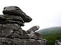
The Dolly Sods Wilderness in West Virginia is a unique part of the Front. It's a wide, flat plateau with many exposed rocks. The cliffs here drop steeply, sometimes 2,800 to 3,200 feet (853 to 975 meters).
The strong winds here make it hard for trees to grow tall. You might see some red spruce trees that are "flagged." This means their branches only grow on one side because of the constant wind. This area also has many low-growing plants that are found in colder, northern places.
Importance to People
The Allegheny Front's steep, windy nature has affected how people live and travel in the region.
Travel Challenges
It's hard to build roads or railroads across the Allegheny Front. This makes it difficult to travel and communicate between the areas to its east and west. In the 1800s, building a way across the Front was very important for connecting the Midwest by rail to the Atlantic coast.
The Pennsylvania Railroad built the famous Horseshoe Curve near Altoona. This special curved track helped trains climb and descend the steep slopes of the Allegheny Front.
Fun and Tourism
Many parts of the Allegheny Front are protected areas. These include parts of the Monongahela National Forest in West Virginia and other state parks.
The few places where you can easily reach the scenic viewpoints are very popular with tourists. The Skyline Overlook along U.S. Route 50 in West Virginia is one such spot. The Front also offers amazing views from other highways and mountains nearby.
Wind Power
The Allegheny Front is a great place for wind turbines because it's so windy. The NedPower Mount Storm Wind Project in West Virginia has 132 wind turbines. They stretch for 12 miles (19 km) along the Front.
Built between 2006 and 2008, this project can create enough electricity for about 66,000 homes and businesses. However, some groups are concerned about building more wind farms on forested mountaintops.
Images for kids
-
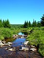
Red Creek in the Dolly Sods area. Its water flows to the Gulf of Mexico.
-
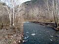
Seneca Creek flows into the Atlantic Ocean.
-

An American mountain-ash tree, often found on the high cliffs of the Allegheny Front.
-
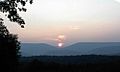
View of Saddle Mountain at sunrise from the Allegheny Front.
-
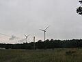
The NedPower Mount Storm Wind Project, a wind farm on the Allegheny Front.
-

Spruce Knob, West Virginia's highest point, has similar geology to the Allegheny Front.
-
Wind-carved rocks at Dolly Sods on the Allegheny Front.


