
Bald Eagle Mountain facts for kids

Quick facts for kids Bald Eagle Mountain |
|
|---|---|

Bald Eagle Mountain
Location in Pennsylvania
|
|
| Highest point | |
| Elevation | 2,112 ft (644 m) |
| Geography | |
| Location | Pennsylvania, U.S. |
| Parent range | Appalachian Mountains |
| Topo map | USGS Jersey Shore (PA) Quadrangle |
Bald Eagle Mountain is a long, narrow mountain ridge in central Pennsylvania, United States. It is part of the Appalachian Mountains, known for their parallel ridges and valleys. This mountain runs east of the Allegheny Front and northwest of Mount Nittany.
The ridge follows the southeast side of Bald Eagle Creek. It also lies south of the West Branch Susquehanna River. Bald Eagle Mountain is the westernmost ridge in its part of the Appalachians. It helps separate several important valleys, including the West Branch Susquehanna Valley and Nittany Valley.
This impressive ridge stretches about 60 miles (97 km) across several counties. You can find it in Centre, Clinton, and Lycoming counties. Part of the ridge even forms a border between Blair and Huntingdon counties. Its journey begins near Tyrone and ends near Williamsport.
Bald Eagle Mountain is a popular spot for both soaring birds and glider pilots. They use the air currents that rise along its slopes to fly high. It is one of the best places in the eastern United States to watch golden eagles migrate. The Ridge Soaring Gliderport is located at the base of this ridge. The mountain is covered by a beautiful forest of oak and hickory trees.
Contents
Exploring Bald Eagle Mountain
Crossing the Ridge

Many roads and rivers cut through Bald Eagle Mountain. Some roads, like the Julian and Unionville Pikes, cross over the ridge. Major highways such as U.S. Route 322 and Interstate 99 pass through a wide opening called Skytop.
Other roads use natural gaps formed by water. For example, Interstate 80 goes through Curtin Gap. Spring Creek and Fishing Creek also create gaps where roads like U.S. Route 220 cross. Near its eastern end, U.S. Route 15 crosses through another natural opening south of Williamsport.
A Home for Wildlife and Adventure
Bald Eagle Mountain is a vital pathway for many soaring birds. These birds, like the majestic golden eagle, use the mountain's updrafts during their long migrations. It is a fantastic place for birdwatching, especially in the fall.
Glider pilots also love this ridge. They can fly for hours using the same rising air currents that birds use. The Ridge Soaring Gliderport is a famous place where people learn and practice glider flying. The mountain's slopes provide perfect conditions for this exciting sport.
The mountain is also home to a rich forest. Tall oak and hickory trees cover its slopes. This provides a habitat for many animals and plants.
How Bald Eagle Mountain Was Formed
Ancient Earth Movements
Bald Eagle Mountain is part of the Ridge and Valley region of the Appalachian Mountains. Millions of years ago, powerful forces deep within the Earth pushed and folded layers of rock. This happened during a time called the Alleghanian orogeny. Imagine pushing a rug from both ends; it creates wrinkles. Similarly, the Earth's crust wrinkled, forming huge arches.
One of these giant arches was called the Nittany Arch. It was once a mountain as tall as the Himalayas! Over vast periods, wind, rain, and ice slowly wore down this enormous mountain. This process is called erosion.
Rocks and Erosion
As the Nittany Arch eroded, different layers of rock became exposed. Some rocks, like sandstone and quartzite, are very hard and resist erosion. Other rocks, like shale, are softer and wear away more easily.
Bald Eagle Mountain formed from these harder rock layers. These layers were tilted almost straight up on the side of the ancient Nittany Arch. Because the hard rocks resisted erosion, they stood tall, forming the ridge we see today. The softer rocks around them eroded away, creating the valleys.
The mountain actually has a "double crest." This means it looks like two parallel ridges with a slight dip in between. This unique shape is because of how two very hard rock layers, the Bald Eagle sandstone and the Tuscarora quartzite, are separated by a slightly softer layer of Juniata shale. The harder layers form the higher crests, while the softer layer creates the dip.
Building Roads and Protecting Water
Sometimes, rocks found in Bald Eagle Mountain contain minerals like pyrite. When these minerals are exposed to air and water, they can create a mild acid. This can be a challenge when building roads or other structures.
For example, when Interstate 99 was being built across Bald Eagle Mountain, engineers had to be very careful. They worked closely with environmental experts to manage the excavated rock. This ensured that the construction did not cause problems for the local water sources. It shows how important it is to understand the geology of an area when planning big projects.

Images for kids
-
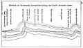
A simplified diagram showing how rock layers are folded.

See also
