Lycoming County, Pennsylvania facts for kids
Quick facts for kids
Lycoming County
|
|||
|---|---|---|---|
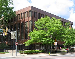
The Lycoming County courthouse in Williamsport
|
|||
|
|||
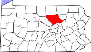
Location within the U.S. state of Pennsylvania
|
|||
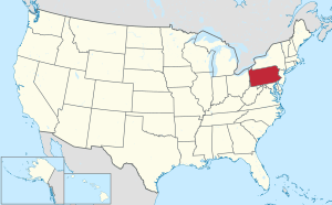 Pennsylvania's location within the U.S. |
|||
| Country | |||
| State | |||
| Founded | April 13, 1795 | ||
| Named for | Lycoming Creek | ||
| Seat | Williamsport | ||
| Largest city | Williamsport | ||
| Area | |||
| • Total | 1,244 sq mi (3,220 km2) | ||
| • Land | 1,229 sq mi (3,180 km2) | ||
| • Water | 15 sq mi (40 km2) 1.2%% | ||
| Population
(2020)
|
|||
| • Total | 114,188 | ||
| • Density | 93/sq mi (36/km2) | ||
| Time zone | UTC−5 (Eastern) | ||
| • Summer (DST) | UTC−4 (EDT) | ||
| Congressional districts | 9th, 15th | ||
Lycoming County is a special area called a county in Pennsylvania. It is located in the central part of the state. In 2020, about 114,188 people lived here. The main town, or county seat, is Williamsport.
Lycoming County is also known as the Williamsport metropolitan statistical area. It is about 130 miles (209 km) northwest of Philadelphia. It is also about 165 miles (266 km) east-northeast of Pittsburgh. Lycoming County is the largest county in Pennsylvania by land area.
Contents
History of Lycoming County
How Lycoming County Was Formed
Lycoming County was created on April 13, 1795. It was formed from a larger area called Northumberland County. Back then, Lycoming County was much bigger than it is today. It covered most of what is now north-central Pennsylvania.
Many other counties were later made from land that was once part of Lycoming County. These include Armstrong, Bradford, Centre, and Clearfield. Other counties formed from it are Clinton, Indiana, Jefferson, and McKean. Also, Potter, Sullivan, Tioga, Venango, Warren, Forest, Elk, and Cameron were formed.
The county was first going to be named Jefferson County. This was to honor Thomas Jefferson. But people decided against it. They tried other names like Susquehanna County and Muncy County. Finally, they chose Lycoming County. It was named after Lycoming Creek. This creek was important in a land dispute before the American Revolution.
Important "Firsts" in Lycoming County
- 1615: The first European to visit Lycoming County was Étienne Brûlé. He was a French explorer. Brûlé traveled down the West Branch Susquehanna River. He was captured by a local Native American tribe near Muncy. He later escaped and went back to Canada.
- 1761: The first permanent homes were built in Muncy. These were three log cabins. They were built by Bowyer Brooks, Robert Roberts, and James Alexander.
- 1772: The first gristmill was built on Muncy Creek by John Alward. A gristmill grinds grain into flour.
- 1775: The first public road was built along the West Branch Susquehanna River. This road followed an old Native American trail. It went from Fort Augusta to Bald Eagle Creek.
- 1786: The first church in the county was the Lycoming Presbyterian church. It was in Jaysburg, which is now part of Williamsport.
- 1792: The first sawmill was built on Lycoming Creek by Roland Hall. Sawmills cut logs into lumber.
- 1795: The first elections for Lycoming County government were held. This happened soon after the county was formed. Samuel Stewart became the first county sheriff. John Hanna, Thomas Forster, and James Crawford were the first county commissioners.
- 1823: The county government paid for the first bridges. These bridges were built over Loyalsock and Lycoming Creeks.
- 1839: The first railroad was built. It connected Williamsport with Ralston. Ralston is in northern Lycoming County. The railroad followed Lycoming Creek.
Geography of Lycoming County
Lycoming County covers about 1,244 square miles (3,222 km²). Most of this is land, about 1,229 square miles (3,183 km²). About 15 square miles (39 km²) is water. This means 1.2% of the county is water. Lycoming County is the largest county in Pennsylvania by land area. It is even larger than the state of Rhode Island. The county has a humid continental climate. This means it has warm summers.
Mountains and Plateaus
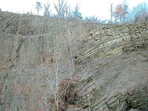
Lycoming County has different types of land. In the south, you can find the Appalachian Mountains. In the north and east, there is the Allegheny Plateau. This plateau also looks like mountains. In between these areas is the valley of the West Branch Susquehanna River.
West Branch Susquehanna River
The West Branch of the Susquehanna River enters Lycoming County near Jersey Shore. The river then flows generally east. It makes some big curves. It passes through Williamsport and Montoursville. These towns are on the north side of the river. Duboistown and South Williamsport are on the south side.
The river flows just north of Bald Eagle Mountain. This is one of the northernmost ridges of the Appalachian Mountains. The river then turns south near Muncy. It continues south past Montgomery. Then it leaves Lycoming County. The river eventually joins the North Branch Susquehanna River. All of its water flows into the Chesapeake Bay.
Major Creeks and Waterways
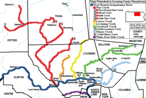
Many important creeks flow into the West Branch Susquehanna River in Lycoming County. On the north side of the river, from west to east, they are:
- Pine Creek (and Little Pine Creek)
- Larrys Creek
- Lycoming Creek
- Loyalsock Creek
- Muncy Creek (and Little Muncy Creek)
White Deer Hole Creek is the only major creek on the south side of the river. It flows from west to east. All the water in Lycoming County eventually drains into the Chesapeake Bay.
Counties Next to Lycoming County
Lycoming County shares borders with nine other counties. This is a lot for a U.S. county, because Lycoming County is so large.
- Bradford County (northeast)
- Clinton County (west)
- Columbia County (southeast)
- Montour County (south)
- Northumberland County (south)
- Potter County (northwest)
- Sullivan County (east)
- Tioga County (north)
- Union County (southwest)
Population of Lycoming County
| Historical population | |||
|---|---|---|---|
| Census | Pop. | %± | |
| 1800 | 5,414 | — | |
| 1810 | 11,006 | 103.3% | |
| 1820 | 13,517 | 22.8% | |
| 1830 | 17,636 | 30.5% | |
| 1840 | 22,649 | 28.4% | |
| 1850 | 26,257 | 15.9% | |
| 1860 | 37,399 | 42.4% | |
| 1870 | 47,626 | 27.3% | |
| 1880 | 57,486 | 20.7% | |
| 1890 | 70,579 | 22.8% | |
| 1900 | 75,663 | 7.2% | |
| 1910 | 80,813 | 6.8% | |
| 1920 | 83,100 | 2.8% | |
| 1930 | 93,421 | 12.4% | |
| 1940 | 93,633 | 0.2% | |
| 1950 | 101,249 | 8.1% | |
| 1960 | 109,367 | 8.0% | |
| 1970 | 113,296 | 3.6% | |
| 1980 | 118,416 | 4.5% | |
| 1990 | 118,710 | 0.2% | |
| 2000 | 120,044 | 1.1% | |
| 2010 | 116,111 | −3.3% | |
| 2020 | 114,188 | −1.7% | |
| U.S. Decennial Census 1790–1960 1900–1990 1990–2000 2010–2019 |
|||
In 2000, there were 120,044 people living in Lycoming County. There were 47,003 households. About 30% of these households had children under 18 living there. The average household had 2.44 people. The average family had 2.95 people.
The population was spread out by age. About 23% of people were under 18. About 16% were 65 years or older. The average age was 38 years old. For every 100 females, there were about 95.6 males.
2020 Census Data
| Race | Number | Percent |
|---|---|---|
| White | 99,687 | 87.3% |
| Black or African American | 5,672 | 5% |
| Native American | 191 | 0.2% |
| Asian | 923 | 0.81% |
| Pacific Islander | 27 | 0.02% |
| Other/Mixed | 5,314 | 4.7% |
| Hispanic or Latino | 2,374 | 2.1% |
Education in Lycoming County
Colleges and Universities
Lycoming County is home to two colleges:
- Lycoming College
- Pennsylvania College of Technology
Public School Districts
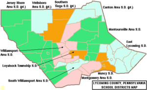
Many public school districts serve the students in Lycoming County. Some of these districts also cover parts of other counties.
- Canton Area School District
- East Lycoming School District
- Jersey Shore Area School District
- Loyalsock Township School District
- Montgomery Area School District
- Montoursville Area School District
- Muncy School District
- South Williamsport Area School District
- Southern Tioga School District
- Wellsboro Area School District
- Williamsport Area School District
Other Public Education Centers
- Lycoming Career Technical Center in Hughesville helps students learn job skills.
- BLAST Intermediate Unit #17 helps local schools with services and programs.
Private Schools
There are also many private schools in Lycoming County. These schools offer different types of education.
- Bald Eagle School - Montgomery
- Brookside School - Montgomery
- Countryside School - Jersey Shore
- Fairfield Academy - Montoursville
- LCCCs Children's Development Center - Williamsport
- Mountain View Christian School - South Williamsport
- Mountain View School - Williamsport
- Pine Woods Nippenose Valley - Jersey Shore
- Scenic Mountain Parochial School - Allenwood
- St John Neumann Regional Academy - Williamsport
- St John Neumann Regional Academy at Faxon - Williamsport
- St John Neumann Regional Academy High School Campus - Williamsport
- Valley Bell School - Montgomery
- West Branch School - Williamsport
- White Deer Valley School - Montgomery
- Williamsport Christian School - Williamsport
Libraries
Lycoming County has six public libraries where you can borrow books and learn.
- James V. Brown Library (Williamsport)
- Hughesville Area Public Library
- Jersey Shore Public Library
- Dr. W.B. Konkle Memorial Library (Montoursville)
- Montgomery Area Public Library
- Muncy Public Library
Transportation in Lycoming County
Main Roads
Many important highways run through Lycoming County. These roads help people travel around the county and to other places.
 Future I‑99
 I-180
I-180 US 15
US 15 US 220
 PA 14
PA 14 PA 42
PA 42 PA 44
PA 44 PA 54
PA 54 PA 87
PA 87 PA 118
 PA 184
 PA 239
 PA 284
 PA 287
 PA 405
 PA 414
 PA 442
 PA 554
 PA 654
 PA 664
 PA 864
 PA 880
 PA 973
Airports
Lycoming County has two public airports.
- The Williamsport Regional Airport offers commercial flights to Washington D.C. It also handles private jets.
- The Jersey Shore Airport has a grass runway. It is mainly used for small aircraft.
Recreation and Parks
Lycoming County has great places for outdoor fun and relaxation.
- There are three Pennsylvania state parks:
- Parts of two Pennsylvania state forests are in Lycoming County:
- Tiadaghton State Forest in the south and west
- Loyalsock State Forest in the east
Communities in Lycoming County
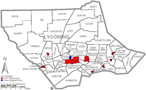
Pennsylvania has different types of towns and areas. These include cities, boroughs, and townships. Here are the communities in Lycoming County:
City
- Williamsport (This is the main town, or county seat)
Boroughs
- Duboistown
- Hughesville
- Jersey Shore
- Montgomery
- Montoursville
- Muncy
- Picture Rocks
- Salladasburg
- South Williamsport
Townships
Townships are another type of local government area.
- Anthony
- Armstrong
- Bastress
- Brady
- Brown
- Cascade
- Clinton
- Cogan House
- Cummings
- Eldred
- Fairfield
- Franklin
- Gamble
- Hepburn
- Jackson
- Jordan
- Lewis
- Limestone
- Loyalsock
- Lycoming
- McHenry
- McIntyre
- McNett
- Mifflin
- Mill Creek
- Moreland
- Muncy
- Muncy Creek
- Nippenose
- Old Lycoming
- Penn
- Piatt
- Pine
- Plunketts Creek
- Porter
- Shrewsbury
- Susquehanna
- Upper Fairfield
- Washington
- Watson
- Wolf
- Woodward
Census-Designated Places (CDPs)
These are areas the U.S. Census Bureau defines for collecting data. They are not official towns.
- Faxon
- Garden View
- Kenmar
- Oval
- Rauchtown (mostly in Clinton County)
Other Small Communities
These are other small, unincorporated communities in the county.
- Antes Fort
- Balls Mills
- Barbours
- Cammal
- Cedar Run
- Chemung
- Hoppestown
- Huntersville
- Jersey Mills
- Lairdsville
- Leolyn
- Linden
- Nisbet
- Pennsdale
- Proctor
- Ralston
- Roaring Branch
- Slate Run
- Unityville
Community Population Ranking (2010 Census)
This table shows the population of the largest communities in Lycoming County based on the 2010 census. † county seat
| Rank | City/Town/etc. | Type of Community | Population (2010 Census) |
|---|---|---|---|
| 1 | † Williamsport | City | 29,381 |
| 2 | South Williamsport | Borough | 6,379 |
| 3 | Montoursville | Borough | 4,615 |
| 4 | Jersey Shore | Borough | 4,361 |
| 5 | Kenmar | CDP | 4,124 |
| 6 | Garden View | CDP | 2,503 |
| 7 | Muncy | Borough | 2,477 |
| 8 | Hughesville | Borough | 2,128 |
| 9 | Montgomery | Borough | 1,579 |
| 10 | Faxon | CDP | 1,395 |
| 11 | Duboistown | Borough | 1,205 |
| 12 | Rauchtown (mostly in Clinton County) | CDP | 726 |
| 13 | Picture Rocks | Borough | 678 |
| 14 | Oval | CDP | 361 |
| 15 | Salladasburg | Borough | 238 |
See also
 In Spanish: Condado de Lycoming para niños
 | Kyle Baker |
 | Joseph Yoakum |
 | Laura Wheeler Waring |
 | Henry Ossawa Tanner |


