Salladasburg, Pennsylvania facts for kids
Quick facts for kids
Salladasburg, Pennsylvania
|
|
|---|---|
|
Borough
|
|

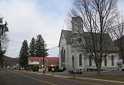
Salladasburg United Methodist Church and Cohick's Trading Post
|
|

Location of Salladasburg in Lycoming County, Pennsylvania.
|
|

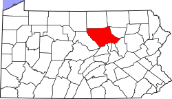
Map of Pennsylvania highlighting Lycoming County
|
|
| Country | United States |
| State | Pennsylvania |
| County | Lycoming |
| Settled | 1837 |
| Incorporated (borough) | 1884 |
| Area | |
| • Total | 0.79 sq mi (2.05 km2) |
| • Land | 0.78 sq mi (2.01 km2) |
| • Water | 0.01 sq mi (0.03 km2) |
| Elevation | 652 ft (199 m) |
| Population
(2020)
|
|
| • Total | 254 |
| • Estimate
(2021)
|
252 |
| • Density | 289.58/sq mi (111.75/km2) |
| Time zone | UTC-5 (Eastern Time Zone (North America)) |
| • Summer (DST) | UTC-4 (EDT) |
| ZIP code |
17740
|
| Area code(s) | 570 |
| FIPS code | 42-67616 |
| GNIS feature ID | 1186873 |
Salladasburg is a small town, also called a borough, in Lycoming County, Pennsylvania, United States. In 2020, about 254 people lived there, making it the smallest borough in Lycoming County. It is part of the larger Williamsport, Pennsylvania area.
Salladasburg is located next to Larrys Creek, where another stream called the Second Fork of Larrys Creek joins it. You can find it where two main roads, Pennsylvania Route 287 and Pennsylvania Route 973, cross each other.
History of Salladasburg
Salladasburg was first planned out by a person named Jacob P. Sallada in 1837. He created the town by setting up lots for homes. He also built a church that could be used by both Lutheran and Presbyterian groups.
The town grew over time. In 1890, about 374 people lived there. Salladasburg used to have many different stores, shops, a hotel, a gristmill (which grinds grain), and a tannery (where leather is made). There were also two schools and three churches. Salladasburg officially became a borough on January 12, 1884.
Geography and Location
Salladasburg is located at coordinates 41 degrees, 16 minutes, 40 seconds North and 77 degrees, 13 minutes, 33 seconds West. This means it's in the northern part of the world and west of the main longitude line. It is completely surrounded by Mifflin Township.
If you were to fly like a bird, Salladasburg is about 130 miles (209 kilometers) northwest of Philadelphia. It is also about 165 miles (266 kilometers) east-northeast of Pittsburgh.
The United States Census Bureau says that the borough covers a total area of about 0.8 square miles (2.07 square kilometers). All of this area is land.
Population and People
| Historical population | |||
|---|---|---|---|
| Census | Pop. | %± | |
| 1880 | 312 | — | |
| 1890 | 374 | 19.9% | |
| 1900 | 261 | −30.2% | |
| 1910 | 280 | 7.3% | |
| 1920 | 208 | −25.7% | |
| 1930 | 227 | 9.1% | |
| 1940 | 237 | 4.4% | |
| 1950 | 250 | 5.5% | |
| 1960 | 255 | 2.0% | |
| 1970 | 239 | −6.3% | |
| 1980 | 273 | 14.2% | |
| 1990 | 301 | 10.3% | |
| 2000 | 260 | −13.6% | |
| 2010 | 238 | −8.5% | |
| 2020 | 254 | 6.7% | |
| 2021 (est.) | 252 | 5.9% | |
| Sources: | |||
In the year 2000, there were 260 people living in Salladasburg. These people lived in 105 households, and 70 of these were families. Most of the people living in the borough were White.
About 30.5% of the households had children under 18 years old. Many households (48.6%) were married couples living together. The average household had about 2.48 people.
The population in 2000 was spread out by age. About 27.7% were under 18 years old. Around 28.1% were between 25 and 44 years old. The median age, which is the middle age of all the people, was 36 years old.
See also
 In Spanish: Salladasburg para niños
 | Charles R. Drew |
 | Benjamin Banneker |
 | Jane C. Wright |
 | Roger Arliner Young |

