
Larrys Creek facts for kids
Quick facts for kids Larrys Creek |
|
|---|---|

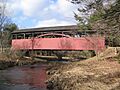
Larrys Creek and the Cogan House Covered Bridge in Cogan House Township, Pennsylvania
|
|

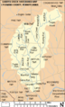
Map showing Larrys Creek, its major tributaries and watershed
|
|

Location of the Mouth of Larrys Creek in Lycoming County, Pennsylvania
|
|
| Country | United States |
| State | Pennsylvania |
| County | Lycoming |
| Physical characteristics | |
| Main source | near the hamlet of Steam Valley Cogan House Township, Lycoming County, Pennsylvania 1,740 ft (530 m) 41°27′13″N 77°08′12″W / 41.45361°N 77.13667°W |
| River mouth | West Branch Susquehanna River Piatt Township, Lycoming County, Pennsylvania 515 ft (157 m) 41°13′00″N 77°13′13″W / 41.21667°N 77.22028°W |
| Length | 22.9 mi (36.9 km) |
| Discharge (location 2) |
|
| Basin features | |
| Basin size | 89.1 sq mi (231 km2) |
Larrys Creek is a stream about 22.9-mile-long (36.9 km) in Lycoming County, Pennsylvania. It flows into the West Branch Susquehanna River. The creek is part of the larger Chesapeake Bay area, and its watershed covers 89.1 square miles (231 km2). This area includes six townships and one borough.
Larrys Creek starts in the Allegheny Plateau and flows south. It passes through areas with different types of rocks like sandstone, limestone, and shale. Long ago, the Susquehannock people lived in this valley, followed by the Lenape and other tribes. The first European settler, Larry Burt, lived near the creek's mouth by 1769. The creek is named after him.
In the 1800s, the area around Larrys Creek was important for logging. There were many sawmills, grist mills, and leather tanneries. People even mined coal and iron here. A newspaper in 1903 said that "No other stream in the country had so many mills in so small a territory." To help with transportation, a plank road was built along the creek.
Today, most of the Larrys Creek watershed is forest (83.1%) and farmland (15.7%). About 9,000 acres (3,600 ha) of forest are protected for hunting and fishing. The water quality is very good, and the creek is even used for canoeing. A water filtration plant on Larrys Creek provides clean water to over 2,500 homes and businesses.
Contents
What's in a Name?
Larrys Creek gets its name from Larry Burt. He was the first European settler in the area. He lived near where the creek meets the river, in what is now Piatt Township. Larry Burt traded with the Native Americans. Some stories say he even had a Native American wife.
Larry Burt was already living there when surveyors arrived in 1769. This was after the land was bought by the Pennsylvania government. He disappeared sometime after that, perhaps moving west with the Native Americans.
Larrys Creek is special because it's the only big creek in Lycoming County without a known Native American name. It's also the only stream named "Larrys Creek" on official maps of the United States. Even though some signs say "Larry's Creek" with an apostrophe, the official name does not have one.
The creek has given its name to a small village at its mouth, also called Larrys Creek. Another village further upstream is called "Larryville." Even the town of Salladasburg used to be known as "Larrys Creek."
The "First Fork" and "Second Fork" are major branches of Larrys Creek. They are named in the order you find them as you travel upstream. "Lawshe Run" is a branch of the Second Fork, named after Robert Lawshe. He started a tannery in Salladasburg in 1848. "Seeley Run" is a smaller branch named after Mr. Seely. He built the first sawmill on Larrys Creek in 1796.
Where Does Larrys Creek Flow?
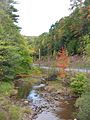
Larrys Creek is the only major stream in Lycoming County that stays entirely within the county. The creek starts in northern Lycoming County, in Cogan House Township. Its source is near a small place called Steam Valley, high up at 1,740 feet (530 m).
From there, it flows west and then southwest through the village of Cogan House. It even goes under the historic Cogan House Covered Bridge.

The creek then turns south, flowing through Pennsylvania State Game Lands Number 114. For about 3 miles (4.8 km), only a trail or small road runs beside it. It passes through Mifflin Township and then into Anthony Township. Here, it flows past a water filtration plant. There's a dam here that is 8.5 feet (2.6 m) tall.
Further south, a stream called Roaring Run joins Larrys Creek. Roaring Run is the only part of the watershed that gets some pollution from old coal mines. This happens about 10.4 miles (16.7 km) from the creek's mouth.
Larrys Creek then heads southwest back into Mifflin Township. It flows through the borough of Salladasburg. In Salladasburg, the Second Fork of Larrys Creek, its biggest branch, joins it. This is about 5.8 miles (9.3 km) from the mouth.
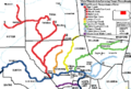
The Second Fork starts near White Pine and flows south through Brookside. Pennsylvania Route 287 runs next to the Second Fork for its entire length. It then continues alongside Larrys Creek all the way to U.S. Route 220.

Just south of Salladasburg, the First Fork of Larrys Creek joins the main creek. This is about 4.2 miles (6.8 km) from the mouth. Another stream, Canoe Run, joins Larrys Creek about 2.8 miles (4.5 km) from its mouth.
Larrys Creek then enters Piatt Township. It flows through the village of Larryville, where Seeley Run joins it. Finally, it flows into the West Branch Susquehanna River. This is about 2.6 miles (4.2 km) east of Jersey Shore, at an elevation of 515 feet (157 m).
The creek drops about 1,225 feet (373 m) from its source to its mouth. This means it drops about 53.5 feet for every mile it flows. The creek's path is fairly straight.
How Much Water Flows in Larrys Creek?
The United States Geological Survey (USGS) has measured the water flow in Larrys Creek. Near the village of Cogan House, the average flow was about 10.8 cubic feet per second (0.306 cubic meters per second) from 1961 to 1978.
Near the creek's mouth, the average flow was 66.0 cubic feet per second (1.87 cubic meters per second) between 1970 and 1975. The flow could be as high as 114 cubic feet per second or as low as 8.8 cubic feet per second. Lycoming County also has a gauge at Salladasburg to measure water height for flood warnings.
What Kind of Rocks and Landforms Are in the Larrys Creek Area?

Larrys Creek flows through a mountainous area made of sandstone, limestone, and shale. The creek starts in the Allegheny Plateau and ends in the Ridge-and-valley Appalachians. The southern part of the watershed has rocks from the Devonian period. Further north, there are rocks from the Mississippian and Pennsylvanian periods.
In the 1800s, people mined iron ore in the watershed, especially south of Salladasburg. The valley where Larrys Creek flows is narrow, with steep hills and mountains. The creek's branches form a pattern like the branches of a tree.
The Second Fork flows along Henson Ridge and Puterbaugh Mountain. The First Fork flows past Little Round Top and also Puterbaugh Mountain. These "Points" (like Harris Point and Fishery Point) are all part of the Allegheny Front, which is the edge of the Allegheny Plateau.
The Larrys Creek watershed also has some bituminous coal deposits and a small, deep natural gas field. A very large source of natural gas is the Marcellus Shale. This rock layer is about 1.5 to 2.0 miles (2.4 to 3.2 km) below the surface here. It stretches from New York through Pennsylvania to Ohio and West Virginia.
Drilling for natural gas started in the Larrys Creek watershed in Mifflin Township in 2007. By 2008, all wells drilled in Lycoming County were producing natural gas. Special methods are used to get the gas out of the Marcellus Shale, including pumping sand and water into the well.
What is the Larrys Creek Watershed Like?
The Larrys Creek watershed is entirely within Lycoming County. It covers about 7.17% of the county's total area. It's the only major creek whose entire watershed is within the county.
The watershed has a population of about 2,513 people (as of 2000). Its total area is 89.1 square miles (231 km2). Most of this area, 74 square miles (190 km2), is covered by forests. About 14 square miles (36 km2) are used for farming.
Important Branches of Larrys Creek
The main smaller streams that flow into Larrys Creek are the First Fork, Second Fork, Roaring Run, Lawshe Run, and Canoe Run. The Second Fork is the largest branch. Its watershed covers 24.9 square miles (64 km2), which is 28% of the total Larrys Creek watershed. The First Fork is the next largest, covering 17.6 square miles (46 km2). Roaring Run makes up 5.7% of the watershed.
Some other smaller streams that flow into Larrys Creek include Seeley Run, Mash Run, Long Run, and Wolf Run.
How Clean is the Water in Larrys Creek?

In the 1800s, cutting down all the trees and industries like coal mines and tanneries harmed the water quality in Larrys Creek. But today, the water quality is very good. However, two small streams that flow into Roaring Run still have some pollution from old, abandoned coal mines. Also, water running off from farms can cause some pollution.
Pennsylvania gets a lot of acid rain. This is because the state produces gases that cause acid rain, and it's also downwind from other places that produce a lot of air pollution. The rocks in this area don't do a good job of neutralizing acid. This makes Larrys Creek especially sensitive to acid rain, which can harm the plants and animals living in the creek.
The Jersey Shore Area Joint Water Authority has a water filtration plant on Larrys Creek. This plant has been there since at least 1914. It provides clean water from the creek to 2,500 customers. These customers are in Jersey Shore, Salladasburg, and several surrounding townships.
Fun Things to Do at Larrys Creek
There are at least two camps along Larrys Creek. "Camp Kiwanis" has a main lodge, cabins, and picnic areas on 50 acres (20 ha). It's used for fire department training, Girl Scouts, weddings, and other group events. Further south, the New Tribes Mission has a camp. Here, Christian missionaries are trained for a year to work with indigenous peoples around the world.
If you like adventure, Larrys Creek is great for canoeing and kayaking when the water is high. There are 8.0 miles (12.9 km) of exciting Class 3 whitewater rapids. There are also 7.4 miles (11.9 km) of easier Class 1 to 2 whitewater.
You can also go hunting and fishing in the area. There are 2,881 acres (1,166 ha) in State Game Lands No. 114. More land is protected in parts of Tiadaghton State Forest. The First Fork of Larrys Creek is known as a "High Quality-Cold Water Fishery." This means it's a great place for cold-water fish.

A section of Larrys Creek is approved for trout fishing by the Pennsylvania Fish and Boat Commission. This means the creek is stocked with trout, and you can fish there during trout season.
There are also private hunting and fishing clubs along Larrys Creek. The "Larrys Creek Fish and Game Club" was started in 1906. It owns over 6,000 acres (2,400 ha) of land. The club works to protect nature and stocks its 7 miles (11 km) of trout stream with thousands of brook and brown trout each year.
Another large private club is the Ogontz Lodge on the First Fork. It was started around 1884 by a banker named Jay Cooke for fishing and hunting. Famous guests like Herbert Hoover (who visited three times, even as President) and Katharine Hepburn have stayed there. The lodge is still open today.
A Look Back: History of Larrys Creek
Early People and Settlers
The oldest signs of human activity along Larrys Creek are two Clovis points found near Salladasburg. These tools are about 12,000 years old. The first people known to live in the Susquehanna River valley were the Susquehannocks. Later, the Lenape and other tribes lived here.
The Great Shamokin Path, an important Native American trail, crossed Larrys Creek near its mouth. This is also where Larry Burt, the first European settler, lived.

In 1768, the British bought this land from the Iroquois. This opened up what is now Lycoming County for settlement. However, there was a disagreement about the border between colonial and Native American lands. Larrys Creek was in this disputed area. So, the settlers there were part of the "Fair Play Men" system. They governed themselves and even declared their independence from Britain on July 4, 1776.
During the American Revolutionary War, British allies attacked settlements in the Susquehanna valley. Many settlers fled in what was called the "Big Runaway" in 1778. They abandoned their homes and farms. Some returned, but had to flee again in 1779. After the war, more settlers moved into the area.
Lycoming County was formed in 1795. This led to more growth. By 1806, Larrys Creek had a bridge near its mouth. This was one of the first bridges on a major creek in the county.
The Lumber Industry
Like other creeks in Lycoming County, Larrys Creek was a place for settlers to build farms. When logging became a big industry in the mid-1800s, the creek's water power was used for sawmills. The first sawmill on the creek was built in 1799.
Because the creek didn't have enough water flow for big log rafts, many small sawmills were built. The Larrys Creek watershed once had 53 sawmills within 22 miles (35 km) of its mouth. People said no other stream had so many mills in such a small area! Most of these mills used water power. By 1903, only two mills were still standing.
Logging left behind many tree limbs and stumps, which could easily catch fire. In 1872, a large forest fire destroyed two villages, Carter and Gould, along Larrys Creek. Today, there are large areas of new forest growth, and small lumber companies still operate in the watershed.
The Plank Road

In 1851, a special plank road was built along Larrys Creek. It went from the village of Larrys Creek north to Salladasburg, and then along the Second Fork to Brookside. It was later extended even further north.
This plank road was a toll road run by "The Larrys Creek Plank Road Company." It helped transport goods from the sawmills, grist mills, mines, and tanneries along the creek. It connected to the railroad and canal at the creek's mouth.
The road was built using hemlock logs. At that time, the bark of hemlock trees was used to tan leather, but the wood wasn't used much. So, hundreds of thousands of stripped hemlock logs were available.
To build the road, the ground was leveled. Then, ties (like railroad ties) were put into the ground. Long, narrow stringers were nailed to the ties. Finally, planks about 8 feet (2.4 m) wide were nailed to the stringers to create a smooth road surface. The road had places for wagons to pull over and pass each other. There were also Toll houses where people paid to use the road.
The plank road was used for about 38 years. Then, a big flood on June 1, 1889, washed away much of it. This same storm also caused the Johnstown Flood. The Cogan House Covered Bridge was the only bridge on Larrys Creek to survive the flood. A fallen tree upstream protected it. This bridge was built in 1877 and is now listed on the National Register of Historic Places. It's one of only three covered bridges left in the county.
After the flood, it was too expensive to rebuild the entire plank road because most of the original forests were gone. Only the section from Salladasburg south to the river was repaired. In 1900, the county took over the road, and tolls ended. As parts of the plank road wore out, they were replaced with dirt and gravel. Today, only the name "Plank Road" remains for a small section of road near U.S. Route 220.

Images for kids
-
Larrys Creek and the Cogan House Covered Bridge in Cogan House Township, Pennsylvania
-
Map showing Larrys Creek, its major tributaries and watershed
-

Relief map of the Larrys Creek Watershed in the dissected Allegheny Plateau
-
Second Fork is the largest tributary; Pennsylvania Route 287 runs parallel to it for its entire length
-
West Branch Susquehanna River (dark blue) and Major Streams in Lycoming County, Pennsylvania; Larrys Creek (orange) is the second major creek entering the river in the county, between the Pine Creek (including Little Pine Creek) (red) and Lycoming Creek (yellow) watersheds
-
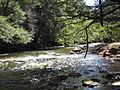
Larrys Creek in Salladasburg is state approved and stocked for trout fishing in season
-
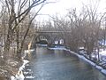
The Lycoming Valley Railroad bridge near the mouth, where the Great Shamokin Path crossed Larrys Creek and Larry Burt lived
-
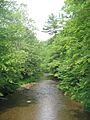
Larrys Creek in Cogan House Township, heading south through State Game Lands 114
-
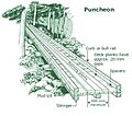
Diagram of a plank road or puncheon
-

Today, the name is all that remains of the Larrys Creek Plank Road
