
West Branch Susquehanna River facts for kids
Quick facts for kids West Branch Susquehanna River |
|
|---|---|

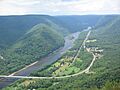
The eastern side of Williamsport, seen from the southeast on Bald Eagle Mountain. In the foreground is the West Branch of the Susquehanna River. Beyond Williamsport can be seen the higher part of the dissected Allegheny Plateau.
|
|

Map of the West Branch Susquehanna River watershed
|
|
| Country | United States |
| State | Pennsylvania |
| Region | Cambria County, Indiana County, Clearfield County, Clinton County, Centre County, Lycoming County, Northumberland County, Union County, Snyder County |
| Physical characteristics | |
| Main source | Allegheny Mountains Near Carrolltown, Cambria County 40°35′55″N 78°43′23″W / 40.59871°N 78.72311°W |
| River mouth | Susquehanna River Northumberland, Northumberland County 423 ft (129 m) 40°52′55″N 76°47′51″W / 40.88194°N 76.79750°W |
| Length | 243 mi (391 km), West-east |
| Basin features | |
| River system | Susquehanna River |
| Basin size | 6,847 sq mi (17,730 km2) |
| Tributaries | |
The West Branch Susquehanna River is a major river in Pennsylvania, USA. It is one of two main parts of the larger Susquehanna River. The West Branch is about 243 miles (391 km) long. It flows entirely within Pennsylvania. It drains a large, mountainous area in the western part of the state, known as the Allegheny Plateau.
The river winds through mountains and gaps, making a big zigzag shape across central Pennsylvania. Long ago, it was an important water path to the Ohio River valley. In the 1700s, the lower part of the river became a key industrial area. Later, in the 1900s, some parts of the river turned yellow or orange. This was due to sulfur from old coal mines nearby.
Contents
River's Journey

The West Branch Susquehanna River starts in western Cambria County. This is close to the town of Carrolltown. It flows north, then into Indiana County at Cherry Tree. After that, it enters Clearfield County.
Near Mahaffey, the river turns northeast. It flows past Curwensville and Clearfield. In northern Clinton County, it turns southeast towards Lock Haven. At Lock Haven, it turns east.
The river then flows through the West Branch Susquehanna Valley. It passes by Williamsport, which is the biggest city on the river. Finally, it turns south and winds around Muncy. It then joins the main Susquehanna River near Sunbury.

Smaller Rivers Joining the West Branch
Many smaller rivers and creeks flow into the West Branch Susquehanna River. These are called tributaries. Here are some of them, from the start of the river to its end:
- Chest Creek joins from the south at Mahaffey.
- Anderson Creek joins from the west in Curwensville.
- Clearfield Creek joins from the south, east of Clearfield.
- Moshannon Creek joins from the south, near Karthaus.
- Sinnemahoning Creek joins from the northwest at Keating.
- Bald Eagle Creek joins from the southwest at Lock Haven.
- Pine Creek and Larrys Creek join from the north near Jersey Shore.
- Lycoming Creek joins from the north at Williamsport.
- Loyalsock Creek joins from the northeast at Montoursville.
- Muncy Creek joins from the northeast at Muncy.
- White Deer Hole Creek joins from the south at Allenwood.
- White Deer Creek joins from the west at White Deer.
- Buffalo Creek joins from the west at Lewisburg.
- Chillisquaque Creek joins from the northeast near its mouth.

River's Past
For many years, the West Branch Susquehanna River was a main path for canoes. It connected the Susquehanna and Ohio valleys. People would carry their canoes and goods over land at Cherry Tree. This connected them to Blacklick Creek, which flows into the Conemaugh River. In the late 1700s, Cherry Tree marked the border between the Pennsylvania Colony and the lands of the Shawnee and Lenape tribes.
The lands along the West Branch were very important for Native Americans. They used them for hunting and farming. Later, during Pennsylvania's big lumbering time, many logs were floated down the West Branch. Canals and railroads were also built along the river. These helped connect towns and move goods, making the area grow.
First People of the Valley
The first people known to live in the West Branch Susquehanna River valley were the Susquehannocks. Their name meant "people of the muddy river." Sadly, by the early 1700s, many had died from sickness or war. Others moved away or joined different tribes.
After that, the lands were mostly used by the Munsee group of the Lenape (or Delaware) people. The powerful Iroquois tribes also had some control over the area.
Early European Settlements
A village called Otstonwakin, or Ostuagy, was very important for early settlers. It was at the mouth of Loyalsock Creek. In the 1740s, Moravian missionaries, like Count Zinzendorf, visited this village. They were spreading their faith in the Pennsylvania wilderness.
In 1768, the British bought land from the Iroquois in the Treaty of Fort Stanwix. This opened up what is now Lycoming County for settlement. However, there was a disagreement about the border between colonial and Native American lands. The colonists thought the border was Pine Creek, but the Iroquois believed it was Lycoming Creek.
People who settled illegally in this disputed area were called the "Fair Play Men". They created their own rules and government. Amazingly, on July 4, 1776, they declared their own independence from Britain!
During the American Revolutionary War, British allies and Native Americans attacked settlements in the Susquehanna valley. After a big attack in 1778, many settlers fled in what was called the "Big Runaway". They left their homes and farms. Their property was burned by the attackers. Some settlers returned later, but had to flee again in 1779. The Sullivan Expedition helped make the area safer, and people returned after the war.
Fort Antes was a fort built around the home of Colonel John Henry Antes around 1778. It was in Lycoming County, overlooking the West Branch Susquehanna River. The local army used the fort for a short time. They had to leave it during the "Big Runaway." Even though it was left empty and attacked, Fort Antes was one of only two buildings in the valley that survived the "Big Runaway."
The Great Log Boom
The Susquehanna Boom was a special system built in the West Branch Susquehanna River. It was made of floating timbers and cribs (stone structures). Its job was to hold logs in the river. These logs were waiting to be cut at the many sawmills along the river. The boom was built in 1846.
A "boom" is like a floating fence across a river. It stops things from floating away. The Susquehanna Boom was about 7 miles (11 km) long. It stretched from Duboistown to Linden. It had 352 cribs, which were like small islands made of stone and sunken wood.
At the top end, a "sheer boom" gathered the logs. This part was 1,000 feet (300 m) long and moved with a hand-powered windlass. The main boom could hold a huge amount of logs, up to 300 million board feet! At the lower end, workers sorted the logs. Each sawmill had its own special mark burned into the logs. Workers would sort them and float them into the correct holding areas for each mill.
From 1861 to 1891, the lumber industry was huge in Lycoming County. The mills produced billions of board feet of lumber. Williamsport became one of the richest cities in Pennsylvania and the United States. Some people, like James H. Perkins and Peter Herdic, became millionaires. However, many of the workers who did the hard job of moving logs in the river earned much less.

Images for kids
-
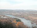
The eastern side of Williamsport, seen from the southeast on Bald Eagle Mountain. In the foreground is the West Branch of the Susquehanna River. Beyond Williamsport can be seen the higher part of the dissected Allegheny Plateau.
-
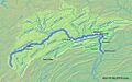
Map of the West Branch Susquehanna River watershed
-
West Branch Susquehanna River near Montgomery, in Lycoming County
-
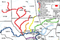
Map of the West Branch Susquehanna River (dark blue) and major tributaries in Lycoming County, Pennsylvania
-
West Branch Susquehanna from Hyner View State Park in Clinton County, Pennsylvania
-
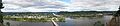
The confluence of the West Branch Susquehanna River (left) and North Branch (center) of the Susquehanna River, along with the borough of Northumberland (left) and city of Sunbury (far right). View is from the Shikellamy State Park Overlook and includes the Shikellamy State Park Marina unit on Packer Island (although the docks had already been taken in for the winter when this photo was taken).
