Pine Creek (Pennsylvania) facts for kids
Quick facts for kids Pine Creek |
|
|---|---|

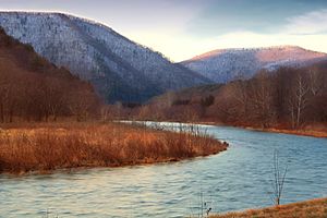
Pine Creek from the Pine Creek Rail Trail in Lycoming County
|
|
| Country | Potter, Tioga, Lycoming and Clinton counties in Pennsylvania, United States |
| Physical characteristics | |
| Main source | Ulysses Township, Potter County 2,420 feet (740 m) |
| River mouth | West Branch Susquehanna River between the boroughs of Avis and Jersey Shore 41°10′16″N 77°16′09″W / 41.1710°N 77.2691°W |
| Length | 87.2 miles (140.3 km) |
| Basin features | |
| Basin size | 979 square miles (2,540 km2) |

Pine Creek is a long stream that flows into the West Branch Susquehanna River. It runs through four counties in Pennsylvania, United States: Potter, Tioga, Lycoming, and Clinton. The creek is about 87.2 miles (140.3 km) (140.3 km) long.
A part of Pine Creek in Tioga County, about 23.25 miles (37.42 km) (37.4 km) long, is special. It is called a Pennsylvania Scenic River. This means it is protected for its natural beauty. Pine Creek is the largest stream that flows into the West Branch Susquehanna River. It also has the biggest watershed (the area of land where all the water drains into the creek) among all the West Branch's streams.
Contents
What's in a Name?
Pine Creek gets its name from the many pine trees that grow along its banks. The Iroquois people, who lived in this area long ago, called it Tiadaghton. Some say this name meant "The River of Pines." Others believe it meant "The Lost or Bewildered River." Interestingly, Pine Creek is known as the largest "creek" in the entire United States!
Where Pine Creek Flows
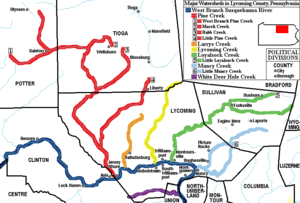
Pine Creek starts in Potter County, about 5 miles (8 km) (8 km) southeast of Ulysses. It flows southeast for about 16 miles (26 km) (26 km) to Galeton. Here, it meets its first big helper stream, the West Branch Pine Creek.
Then, Pine Creek flows east for about 12 miles (19 km) (19 km) into Tioga County. It reaches the village of Ansonia. In Ansonia, it gets water from its second major helper stream, Marsh Creek. After this, Pine Creek turns south again and flows for about 16 miles (26 km) (26 km). This part is the beginning of the famous Pine Creek Gorge. This gorge is like a deep valley, about 1,000 feet (300 m) (300 m) deep in some places!
At the village of Blackwell, Pine Creek meets its third big helper stream, Babb Creek. It keeps flowing southwest for about 14 miles (23 km) (23 km) and enters Lycoming County. Here, it turns southeast and flows for another 28 miles (45 km) (45 km) until it reaches its end.
Near Waterville, Pine Creek gets water from its fourth major helper stream, Little Pine Creek. Pine Creek then continues south. It even forms part of the border between Lycoming and Clinton counties.
Pine Creek finally joins the West Branch Susquehanna River at this border. This meeting point is between the towns of Avis (in Clinton County) and Jersey Shore (in Lycoming County).
The place where Pine Creek starts is very high up, at about 2,420 feet (740 m) (738 m) above sea level. Where it ends, at its mouth, it is much lower, at about 520 feet (160 m) (160 m). This big drop in height, about 1,900 feet (580 m) (580 m), means the water flows downhill quite a bit.
Pine Creek's Watershed
A watershed is like a giant bowl where all the rain and snow melt drains into one main river or stream. Pine Creek's watershed is huge, covering about 979 square miles (2,540 km2) (2,540 km²). This makes it the largest watershed of all the streams that flow into the West Branch Susquehanna River.
Fun Activities and Recreation
Pine Creek and the Pine Creek Gorge are very popular places for outdoor fun! The gorge is so impressive that it's often called the "Grand Canyon of Pennsylvania."
- Hiking: The West Rim Trail is a 30-mile-long (48 km) hiking path. It runs along the western edge of the Pine Creek Gorge, offering amazing views.
- Biking and Walking: The Pine Creek Rail Trail is a flat path that follows the creek through the gorge. It goes from Ansonia all the way to Jersey Shore. This trail used to be a railroad line. The last train ran through the gorge in 1988. Now, it's a perfect place for biking, walking, and enjoying nature.
A Bit of History
An interesting part of Pine Creek's history involves a group called the Fair Play Men. These were settlers who lived in the West Branch Susquehanna River valley between 1773 and 1785. They were living on land claimed by Native Americans, so the government couldn't help them.
Because of this, they created their own rules and system, called the Fair Play System. They elected three leaders who made decisions about land and other issues. In an amazing twist of history, on July 4, 1776, the Fair Play Men wrote their own special declaration of independence from Britain. They did this under a tree called the "Tiadaghton Elm," which was on the west bank of Pine Creek, very close to where it meets the West Branch Susquehanna River.
Bridges Over Pine Creek
Several bridges cross Pine Creek, helping people get from one side to the other.
- The Bridge in Porter Township was built in 1889.
- The Bridge in Brown Township was built in 1890.
- The English Center Suspension Bridge was built in 1891.
 | George Robert Carruthers |
 | Patricia Bath |
 | Jan Ernst Matzeliger |
 | Alexander Miles |


