Tioga County, Pennsylvania facts for kids
Quick facts for kids
Tioga County
|
|
|---|---|
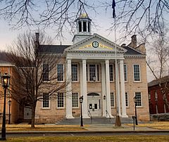
Tioga County Courthouse
|
|
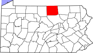
Location within the U.S. state of Pennsylvania
|
|
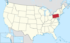 Pennsylvania's location within the U.S. |
|
| Country | |
| State | |
| Founded | October 13, 1812 |
| Named for | Tioga River |
| Seat | Wellsboro |
| Largest borough | Mansfield |
| Area | |
| • Total | 1,137 sq mi (2,940 km2) |
| • Land | 1,134 sq mi (2,940 km2) |
| • Water | 3.2 sq mi (8 km2) 0.3%% |
| Population
(2020)
|
|
| • Total | 41,045 |
| • Density | 36/sq mi (14/km2) |
| Time zone | UTC−5 (Eastern) |
| • Summer (DST) | UTC−4 (EDT) |
| Congressional district | 15th |
Tioga County is a county located in the state of Pennsylvania. In 2020, about 41,045 people lived there. Its main town, or county seat, is Wellsboro.
The county was officially created on March 26, 1804. It was formed from a part of Lycoming County. Later, it was fully organized in 1812. The county gets its name from the Tioga River. Tioga County is part of the North Central Pennsylvania area of the state.
Contents
History of Tioga County
People from New England and western New York first settled Tioga County. These early settlers were often called "Yankees." They were descendants of English Puritans who came to America long ago.
After the Revolutionary War, many New Englanders moved over the Allegheny Mountains. They followed a rough wagon road to the Tioga River. Because of this, Tioga County felt more like upstate New York than eastern Pennsylvania.
Developers and land sellers helped set up roads and post offices. They built public buildings and invited more people to move to the area. The culture of New England strongly influenced this part of Pennsylvania.
Later, in the late 1800s and early 1900s, more immigrants arrived. People from Ireland, Germany, and eastern Europe came to work in the coal mines. Many of them were Roman Catholic, which added to the different religions in the county.
Geography of Tioga County
Tioga County covers a total area of about 1,137 square miles. Most of this, 1,134 square miles, is land. Only a small part, about 3.2 square miles, is water. It is one of the largest counties in Pennsylvania by land area.
The county has a warm-summer humid continental climate. This means it has warm summers and cold winters. In Wellsboro, the average temperature in January is about 22.8°F. In July, it's around 68.2°F.
Neighboring Counties
Tioga County shares borders with these other counties:
- Steuben County, New York (north)
- Chemung County, New York (northeast)
- Bradford County (east)
- Lycoming County (south)
- Potter County (west)
Population Information
| Historical population | |||
|---|---|---|---|
| Census | Pop. | %± | |
| 1810 | 1,687 | — | |
| 1820 | 4,021 | 138.4% | |
| 1830 | 8,978 | 123.3% | |
| 1840 | 15,498 | 72.6% | |
| 1850 | 23,987 | 54.8% | |
| 1860 | 31,044 | 29.4% | |
| 1870 | 35,097 | 13.1% | |
| 1880 | 45,814 | 30.5% | |
| 1890 | 52,313 | 14.2% | |
| 1900 | 49,086 | −6.2% | |
| 1910 | 42,829 | −12.7% | |
| 1920 | 37,118 | −13.3% | |
| 1930 | 31,871 | −14.1% | |
| 1940 | 35,004 | 9.8% | |
| 1950 | 35,474 | 1.3% | |
| 1960 | 36,614 | 3.2% | |
| 1970 | 39,691 | 8.4% | |
| 1980 | 40,973 | 3.2% | |
| 1990 | 41,126 | 0.4% | |
| 2000 | 41,372 | 0.6% | |
| 2010 | 41,981 | 1.5% | |
| 2020 | 41,045 | −2.2% | |
| U.S. Decennial Census 1790–1960 1900–1990 1990–2000 2010–2017 2010-2020 |
|||
In 2020, the population of Tioga County was 41,045 people.
2020 Census Details
| Race | Num. | Perc. |
|---|---|---|
| White (NH) | 38,257 | 93.2% |
| Black or African American (NH) | 321 | 0.8% |
| Native American (NH) | 73 | 0.17% |
| Asian (NH) | 189 | 0.46% |
| Pacific Islander (NH) | 7 | 0.02% |
| Other/Mixed (NH) | 1,558 | 3.8% |
| Hispanic or Latino | 640 | 1.56% |
Education in Tioga County
Tioga County has many schools and learning centers.
Colleges and Universities
- Mansfield University in Mansfield is part of the Pennsylvania State System of Higher Education.
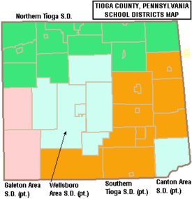
Public School Districts
- Canton Area School District (also in Bradford County and Lycoming County)
- Galeton Area School District (also in Potter County)
- Northern Tioga School District
- Southern Tioga School District (also in Lycoming County)
- Wellsboro Area School District
Private Schools
Here are some private schools in Tioga County:
- Covington Community DCC, Covington
- Irvin Comstock Seventh-Day Adventist School, Wellsboro
- Laurel Youth Services, Blossburg
- Lauries Bright Beginnings CCC, Millerton
- Mansfield Area Nursery School, Mansfield
- Maranatha Mission Learning Community Branch 20, Trout Run
- New Covenant Academy, Mansfield
- Presbyterian Child Development Center, Wellsboro
- Stony Fork Mennonite School, Wellsboro
- Trinity Lutheran School, Wellsboro
- Toddler University, Blossburg
- Toddler University, Trinity
- Wellsboro Montessori Children's Center, Wellsboro
- Wesley Academy, Elkland
Public Libraries
You can find these public libraries in Tioga County:
- Blossburg Memorial Library
- Elkland Area Community Library
- Green Free Library – Wellsboro
- Knoxville Public Library
- Mansfield Free Public Library
- Potter-Tioga County Lib System
- Westfield Public Library
Transportation
Public transportation in Tioga County is provided by BeST Transit.
Major Highways
These are some of the main roads that go through Tioga County:
 Future I‑99
 US 6
US 6 US 15
US 15
 US 15 Bus.
 PA 14
PA 14 PA 49
PA 49 PA 249
 PA 287
 PA 328
 PA 349
 PA 362
 PA 414
 PA 549
 PA 660
Recreation
Tioga County is home to three Pennsylvania state parks, offering great places to explore nature.
- Hills Creek State Park is located a few miles north of U.S. Route 6. It's between Wellsboro and Mansfield.
- Colton Point State Park and Leonard Harrison State Park are both part of the amazing Pine Creek Gorge. This area is often called the "Pennsylvania Grand Canyon." It was carved by Pine Creek.
Communities in Tioga County
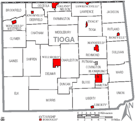
In Pennsylvania, there are different types of towns and areas. These include cities, boroughs, and townships. Here are the boroughs and townships in Tioga County:
Boroughs
Townships
- Bloss
- Brookfield
- Charleston
- Chatham
- Clymer
- Covington
- Deerfield
- Delmar
- Duncan
- Elk
- Farmington
- Gaines
- Hamilton
- Jackson
- Lawrence
- Liberty
- Middlebury
- Morris
- Nelson
- Osceola
- Putnam
- Richmond
- Rutland
- Shippen
- Sullivan
- Tioga
- Union
- Ward
- Westfield
Census-Designated Places
These are special areas defined by the U.S. Census Bureau for collecting population data. They are not official towns or cities.
Ghost Towns
Tioga County has some "ghost towns." These are places where people used to live but don't anymore. This often happened when industries like lumber or coal mining ended. For example, Leetonia was once a town built around a timber company. Other small places like Mardin and Olde Corner also disappeared. Fall Brook was a coal mining site, and Landrus started with a sawmill.
Town Population Ranking
Here's a list of the largest towns and places in Tioga County, based on the 2010 census:
† county seat
| Rank | City/Town/etc. | Municipal type | Population (2010 Census) |
|---|---|---|---|
| 1 | Mansfield | Borough | 3,625 |
| 2 | † Wellsboro | Borough | 3,263 |
| 3 | Elkland | Borough | 1,821 |
| 4 | Blossburg | Borough | 1,538 |
| 5 | Westfield | Borough | 1,064 |
| 6 | Tioga | Borough | 666 |
| 7 | Knoxville | Borough | 629 |
| 8 | Lawrenceville | Borough | 581 |
| 9 | Arnot | CDP | 332 |
| 10 | Millerton | CDP | 316 |
| 11 | Liberty | Borough | 249 |
| 12 | Roseville | Borough | 189 |
See also
 In Spanish: Condado de Tioga (Pensilvania) para niños
 | Charles R. Drew |
 | Benjamin Banneker |
 | Jane C. Wright |
 | Roger Arliner Young |


