Roseville, Pennsylvania facts for kids
Quick facts for kids
Roseville, Pennsylvania
|
|
|---|---|
|
Borough
|
|

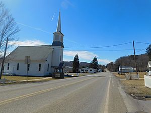
PA 549 southbound through Roseville.
|
|

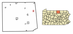
Location of Roseville in Tioga County, Pennsylvania.
|
|
| Country | United States |
| State | Pennsylvania |
| County | Tioga |
| Settled | 1806 |
| Incorporated (borough) | 1876 |
| Area | |
| • Total | 0.47 sq mi (1.23 km2) |
| • Land | 0.47 sq mi (1.23 km2) |
| • Water | 0.00 sq mi (0.00 km2) |
| Elevation | 1,342 ft (409 m) |
| Population
(2020)
|
|
| • Total | 178 |
| • Density | 374.74/sq mi (144.56/km2) |
| Time zone | Eastern (EST) |
| • Summer (DST) | EDT |
| Area code(s) | 570 |
| FIPS code | 42-66232 |
Roseville is a small town, called a borough, in Tioga County, Pennsylvania, United States. In 2020, about 177 people lived there. It is a quiet place with a rich history.
Contents
History of Roseville
Roseville was first settled in 1806 by a doctor named William Rose. He moved to Tioga County from Rutland, Vermont. Dr. Rose was a doctor for people in eastern Tioga and western Bradford Counties.
In 1822, Dr. Rose built a distillery, which made alcoholic drinks. Soon after, his son, William Rose Jr., opened a tavern. A tavern was a place where people could eat, drink, and stay the night. This tavern quickly became a very important place for business in Roseville. Later, a hotel was built to help travelers going between Mansfield and Elmira, New York.
In the late 1800s and early 1900s, Roseville had many businesses. These included a gristmill (which ground grain into flour), a cheese factory, and a paint plant. However, taverns along the main road remained the most popular businesses. In 1888, a big fire destroyed 23 buildings in Roseville. This fire ended the time when taverns were the main businesses.
Roseville used to have its own post office and a public school. The post office, called Rutland Post Office, closed in 1957. The public school closed in 1966. After that, Roseville's students went to school in Mansfield. Later, this school system became part of the Southern Tioga School District.
Geography of Roseville
Roseville is located in Pennsylvania. It is a small area of land, about 0.5 square miles (1.23 square kilometers). The borough is completely surrounded by Rutland Township. This means Rutland Township is all around Roseville.
Population Changes in Roseville
| Historical population | |||
|---|---|---|---|
| Census | Pop. | %± | |
| 1880 | 185 | — | |
| 1890 | 211 | 14.1% | |
| 1900 | 215 | 1.9% | |
| 1920 | 119 | — | |
| 1930 | 99 | −16.8% | |
| 1940 | 133 | 34.3% | |
| 1950 | 126 | −5.3% | |
| 1960 | 162 | 28.6% | |
| 1970 | 178 | 9.9% | |
| 1980 | 211 | 18.5% | |
| 1990 | 230 | 9.0% | |
| 2000 | 207 | −10.0% | |
| 2010 | 189 | −8.7% | |
| 2020 | 177 | −6.3% | |
| 2021 (est.) | 176 | −6.9% | |
| Sources: | |||
The number of people living in Roseville has changed over the years. In 2010, there were 189 people living in the borough. There were 75 households, which are groups of people living together. Most of these were families.
The population density was about 390 people per square mile (150 people per square kilometer). This means that for every square mile of land, there were about 390 people.
In 2010, about 28% of the people in Roseville were under 18 years old. About 9.2% were 65 years old or older. The average age of people in Roseville was 34 years.
Churches in Roseville
There are two churches in Roseville. They are the Roseville Methodist Church and the Independent Baptist Church.
See also
 In Spanish: Roseville (Pensilvania) para niños
 | Charles R. Drew |
 | Benjamin Banneker |
 | Jane C. Wright |
 | Roger Arliner Young |


