Steuben County, New York facts for kids
Quick facts for kids
Steuben County
|
|||
|---|---|---|---|

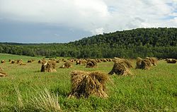
Farmland in rural Steuben County
|
|||
|
|||

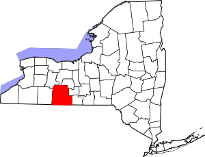
Location within the U.S. state of New York
|
|||
 New York's location within the U.S. |
|||
| Country | |||
| State | |||
| Founded | 1796 | ||
| Named for | Baron von Steuben | ||
| Seat | Bath | ||
| Largest city | Corning | ||
| Area | |||
| • Total | 1,404 sq mi (3,640 km2) | ||
| • Land | 1,391 sq mi (3,600 km2) | ||
| • Water | 14 sq mi (40 km2) 1.0% | ||
| Population
(2020)
|
|||
| • Total | 93,584 | ||
| • Density | 67.3/sq mi (26.0/km2) | ||
| Time zone | UTC−5 (Eastern) | ||
| • Summer (DST) | UTC−4 (EDT) | ||
| Congressional district | 23rd | ||
Steuben County is a county in New York. In 2020, about 93,584 people lived here. The main town, or county seat, is Bath.
The county is named after Baron von Steuben. He was a general from Prussia. He helped the American side during the American Revolutionary War. Steuben County is part of the Southern Tier region of New York.
Contents
History of Steuben County
Steuben County was created on March 8, 1796. It was formed from a much larger area called Ontario County. This land was part of the Phelps and Gorham Purchase.
Over time, parts of Steuben County were used to create other counties. In 1823, a piece of it became part of Yates County. Later, in 1854, another part helped form Schuyler County.
In its early days, Steuben County was connected to the Susquehanna River in Pennsylvania. This river led to the port of Baltimore. Goods like timber and farm products were sent downriver from towns like Addison and Hornellsville. Before the Erie Canal opened in 1825, it was hard to send goods to New York City.
Geography of Steuben County

Steuben County is in the southwest part of New York State. It is right next to the border with Pennsylvania. The county covers about 1,404 square miles. Most of this area, 1,391 square miles, is land. The rest, about 14 square miles, is water.
Counties near Steuben County
Steuben County shares borders with several other counties:
- Ontario County - to the north
- Yates County - to the northeast
- Schuyler County - to the east
- Chemung County - to the east
- Tioga County, Pennsylvania - to the south
- Potter County, Pennsylvania - to the southwest
- Allegany County - to the west
- Livingston County - to the northwest
Population and People
| Historical population | |||
|---|---|---|---|
| Census | Pop. | %± | |
| 1800 | 1,788 | — | |
| 1810 | 7,246 | 305.3% | |
| 1820 | 21,989 | 203.5% | |
| 1830 | 33,851 | 53.9% | |
| 1840 | 46,138 | 36.3% | |
| 1850 | 63,771 | 38.2% | |
| 1860 | 66,690 | 4.6% | |
| 1870 | 67,717 | 1.5% | |
| 1880 | 77,586 | 14.6% | |
| 1890 | 81,473 | 5.0% | |
| 1900 | 82,822 | 1.7% | |
| 1910 | 83,362 | 0.7% | |
| 1920 | 80,627 | −3.3% | |
| 1930 | 82,671 | 2.5% | |
| 1940 | 84,927 | 2.7% | |
| 1950 | 91,439 | 7.7% | |
| 1960 | 97,691 | 6.8% | |
| 1970 | 99,546 | 1.9% | |
| 1980 | 99,217 | −0.3% | |
| 1990 | 99,088 | −0.1% | |
| 2000 | 98,726 | −0.4% | |
| 2010 | 98,990 | 0.3% | |
| 2020 | 93,584 | −5.5% | |
| U.S. Decennial Census 1790-1960 1900-1990 1990-2000 2010-2020 |
|||
In 2000, there were 98,726 people living in Steuben County. The population density was about 71 people per square mile. Most people in the county were White (96.43%). There were also African American, Native American, and Asian residents. About 0.81% of the population was Hispanic or Latino.
The median age in the county was 38 years old. This means half the people were younger than 38 and half were older.
2020 Census Information
| Race | Num. | Perc. |
|---|---|---|
| White (NH) | 84,338 | 90.12% |
| Black or African American (NH) | 1,416 | 1.51% |
| Native American (NH) | 203 | 0.22% |
| Asian (NH) | 1,616 | 1.72% |
| Pacific Islander (NH) | 12 | 0.01% |
| Other/mixed (NH) | 4,281 | 4.6% |
| Hispanic or Latino | 1,718 | 1.83% |
Industries and Jobs
The biggest employer in Steuben County is Corning, Inc.. This company makes special glass and related products. You can also visit the nearby Corning Museum of Glass.
In Hammondsport, there is a wine industry. This town is also home to the Mercury Corporation, which makes custom products. The Glenn H. Curtiss Museum, an aviation museum, is also in Hammondsport.
Education
Steuben County has one college: Corning Community College. Other colleges like Alfred University and Elmira College are close by.
Here are some of the school districts in the county:
- Addison Central School District
- Alfred-Almond Central School District
- Andover Central School District
- Arkport Central School District
- Avoca Central School District
- Bath Central School District
- Bradford Central School District
- Canaseraga Central School District
- Campbell-Savona Central School District
- Canisteo-Greenwood Central School District
- Corning City School District
- Dansville Central School District
- Elmira City School District
- Hammondsport Central School District
- Hornell City School District
- Jasper-Troupsburg Central School District
- Naples Central School District
- Penn Yan Central School District
- Prattsburgh Central School District
- Wayland-Cohocton Central School District
- Whitesville Central School District
Transportation
Major Roads
Many important roads run through Steuben County:
 Interstate 86
 New York State Route 17
 Interstate 99
 U.S. Route 15
 Interstate 390
 New York State Route 15
 New York State Route 21
 New York State Route 36
 New York State Route 414
 New York State Route 415
 New York State Route 417
Airports
Steuben County has two public airports:
Public Buses
Local bus service is available through Hornell Area Transit.
Communities in Steuben County
Larger Towns and Villages
| # | Location | Population | Type | Area |
|---|---|---|---|---|
| 1 | Corning | 11,183 | City | Southeast |
| 2 | Hornell | 8,563 | City | West |
| 3 | †Bath | 5,786 | Village | Northeast |
| 4 | Gang Mills | 4,185 | CDP | Southeast |
| 5 | Canisteo | 2,270 | Village | West |
| 6 | Wayland | 1,865 | Village | Northwest |
| 7 | Painted Post | 1,809 | Village | Southeast |
| 8 | Addison | 1,763 | Village | Southeast |
| 9 | South Corning | 1,145 | Village | Southeast |
| 10 | Avoca | 946 | Village | Northwest |
| 11 | Arkport | 844 | Village | West |
| 12 | Cohocton | 838 | Village | Northwest |
| 13 | Savona | 827 | Village | Northeast |
| 14 | North Hornell | 778 | Village | West |
| 15 | Campbell | 713 | CDP | Southeast |
| 16 | Hammondsport | 661 | Village | Northeast |
| 17 | ††Prattsburgh | 656 | CDP | Northeast |
| 18 | Coopers Plains | 598 | CDP | Southeast |
| 19 | Riverside | 497 | Village | Southeast |
| 20 | ‡Almond | 466 | Village | West |
† - County seat
†† - Former village
‡ - Not completely in this county
Towns
Hamlets
Notable People from Steuben County
Here are some well-known people who were born in Steuben County:
- Stanley C. Armstrong (1888–1950)
- Josiah H. Bonney (1817–1887)
- Olive Byrne (1904–1990)
- Edward Conner (1829–1900)
- Glenn H. Curtiss (1878–1930), a pioneer in aviation
- Jasper Humphrey (1812–1892)
- Artemas Martin (1835–1918), a mathematician
- Selwyn N. Owen (1836–1916), a lawyer
- James A. Parsons (c.1868–1945)
- Omar L. Rosenkrans (1843–1926)
- Eric M. Smith (born 1980)
- Peter Truax (1828–1909), a person known for charity
See also
 In Spanish: Condado de Steuben (Nueva York) para niños
 | Tommie Smith |
 | Simone Manuel |
 | Shani Davis |
 | Simone Biles |
 | Alice Coachman |


