
Hornell, New York facts for kids
Quick facts for kids
Hornell
|
|
|---|---|

Downtown Hornell
|
|
| Nickname(s):
Maple City,
|
|

Hornell, New York
Location in New York
|
|
| Country | United States |
| State | New York |
| County | Steuben |
| First settled | 1790 |
| Incorporated (Town of Hornellsville) | 1820 |
| Incorporated (Village of Hornellsville) | 1852 |
| Incorporated (City of Hornellsville/Hornell) | 1888/1906 |
| Government | |
| • Type | (Mayor-Council) |
| Area | |
| • Total | 3.28 sq mi (8.49 km2) |
| • Land | 3.28 sq mi (8.49 km2) |
| • Water | 0.00 sq mi (0.00 km2) |
| Elevation | 1,161 ft (354 m) |
| Population
(2020)
|
|
| • Total | 8,259 |
| • Density | 2,519.98/sq mi (973.08/km2) |
| Time zone | UTC−5 (Eastern (EST)) |
| • Summer (DST) | UTC−4 (EDT) |
| ZIP Code |
14843
|
| Area code(s) | 607 |
| FIPS code | 36-35672 |
| GNIS feature ID | 0975771 |
Hornell is a city located in Steuben County, New York, in the United States. In 2020, about 8,259 people lived there. The city gets its name from the Hornell family, who were among the first people to settle in the area.
The City of Hornell is surrounded by the Town of Hornellsville. It is about 55 miles (88 km) south of Rochester. Hornell is also close to the western edge of Steuben County.
Hornell is often called the "Maple City." This nickname comes from the many large maple trees that used to grow all over the town. These trees also covered the hills around the Canisteo Valley. Hornell residents love to celebrate Saint Patrick's Day with one of the biggest parades and parties in the area. Many people come out to enjoy the spring weather and show off their green outfits.
Contents
History of Hornell

The area that is now Hornell was first settled in 1790. It was known as "Upper Canisteo" to tell it apart from the community of Canisteo, which was called "Lower Canisteo." The Crosby family were the very first settlers in what would become Hornell.
In 1820, the area officially became a town called "Hornellsville." This name came from an early settler named George Hornell Jr., who built the first gristmill (a mill for grinding grain) there. The City of Hornell was officially created in 1888 as the "City of Hornellsville." Before that, it was organized as the "Village of Hornellsville" in 1852. The name was later changed to Hornell in 1906.
In 1936, a major flood caused parts of the city to go underwater. Because of this, a system of levees (walls built to prevent flooding) was created to protect the city from future floods.
In 1950, Hornell had a population of just over 15,000 people. The city's current mayor is John Buckley, who is a Republican.
Several important buildings in Hornell are listed on the National Register of Historic Places. These include the Hornell Armory, Hornell Public Library, Adsit House, Lincoln School, St. Ann's Federation Building, and the United States Post Office.
Hornell and Railroads

Hornell was once a very important place for railroads. Several train lines passed through or started in Hornell. The companies that ran these railroads often changed their names or routes over time.
- The main Erie Railroad line connected New York City to Dunkirk, New York.
- Erie's Buffalo line connected Hornell to Buffalo, New York. Hornell became a key meeting point where these two main Erie lines connected.
- Another line ran northeast from Hornell to Geneva, New York. This line was later used by the Pittsburg, Shawmut and Northern Railroad.
- The Hornellsville Electric Railway Company and Hornellsville & Canisteo Railway Company provided trolley service. These trolleys ran to North Hornell, Canisteo, and within the city itself. They connected the different train stations from 1892 until 1926.
The most important railroad for Hornell was the New York and Erie Railroad, often called the Erie. It arrived in Hornell in 1850 and started public service on May 14, 1851. Important people like President Millard Fillmore and Secretary of State Daniel Webster rode through Hornell on the first train.
Hornell was a central spot on the Erie line. This made it a great place for the railroad's repair yards. In 1882, a guide to the Erie Railroad mentioned that Hornell had many side-tracks, engine-houses, and repair-shops. This was because the city was a dividing point for different parts of the Erie Railway. It also noted that Hornell had banks, newspapers, a library, churches, and a population of about 9,000 people. Trains going to Buffalo or Niagara Falls would separate here from those going further west.
In 1895, the Erie built a huge barn in Hornell to hold the large number of cattle being shipped east on its trains.
Hornell During the Railroad Era (1860–1960)

For about 100 years, Hornell was a very busy and successful city. Its steam engine shop handled repairs for the entire Erie line. The train station was the most important place in town. Today, it is the Hornell Erie Depot Museum.
Broadway was a wide street with many stores and theaters. Canisteo Street had Hornell's largest hotel, the New Sherwood. The city's main park, Union Park, was also there, along with the high school. Main Street had more businesses, including the Hornell Theater and music stores. East of Main Street was Hornell's Carnegie Library (now the Hornell Public Library), a large grocery store, and the YMCA with the city's only public swimming pool. The Erie repair shops were also in this area.
Hornell After the Railroads (1960–Present)
After 1960, Hornell faced challenges. The population became half of what it was in 1960 and continued to decrease. Passenger train service ended completely by 1970. The old train station was later fixed up and became the Hornell Erie Depot Museum in 2006.
The railroad industry faced tough times as more and more freight was moved by trucks. In 1960, the Erie merged with another railroad to form the Erie Lackawanna. Diesel engines, which needed less repair than steam engines, meant that many railroad workers were laid off. In 1972, a flood from Hurricane Agnes damaged about 200 miles (320 km) of railroad tracks near the Canisteo River. This made it impossible to use the train line southeast of Hornell. The Erie Lackawanna company soon went out of business.

The former Erie repair shops were closed for several years. However, they later reopened to work on diesel engines and do bodywork and painting. Today, these shops are a major employer in Hornell. They are operated by Alstom, a company that builds train parts, railway cars, and passenger locomotives. Train car bodies are shipped from Brazil and put together in Hornell. Alstom has won big contracts, including one to fix up PATCO Speedline's light rail trains and another to build new high-speed trains for Amtrak. In 2021, they won a $1.8 billion contract to build new passenger railcars, which is expected to create 250 new jobs.
Highway Construction
Route 36 Arterial
Hornell's main streets changed a lot around 1972 when the New York Route 36 arterial highway was built. Before this, Route 36, which was Hornell's main north-south road, went along Seneca Street and Canisteo Street. These streets were not wide enough for all the cars and trucks that started using them as railroads declined. Canisteo Street also had a very narrow spot where it went under the Erie Railroad tracks.
The city decided to build a new, wider highway called an arterial. This new road required tearing down 245 houses and many businesses. It also divided the city and replaced Hornell's Union Park. The new four-lane road continued to Canisteo. This change had a big impact on downtown Hornell. Many parts of the south end of downtown were either destroyed or lost their businesses. Seneca Street and Broadway, which used to be busy commercial streets, became quiet side streets.
The Southern Tier Expressway (Interstate 86)
In the 1960s, it was decided to make the western part of New York Route 17 into a faster expressway. This expressway was routed through the Hornell area because it was thought to have more potential for growth. Interstate 86 runs across New York's Southern Tier. It crosses New York State Route 36 between Hornell and Arkport. Today, Interstate 86 is Hornell's main highway.
Geography
Hornell is located at 42.3244 degrees North latitude and 77.6603 degrees West longitude. The city is about 1,160 feet (354 meters) above sea level.
According to the United States Census Bureau, the city covers a total area of 2.7 square miles (8.49 square kilometers), and all of it is land.

Hornell is situated on the Canisteo River and is surrounded by the lower hills of the Allegheny Mountains.
Population Changes
| Historical population | |||
|---|---|---|---|
| Census | Pop. | %± | |
| 1870 | 4,552 | — | |
| 1880 | 8,195 | 80.0% | |
| 1890 | 10,996 | 34.2% | |
| 1900 | 11,918 | 8.4% | |
| 1910 | 13,617 | 14.3% | |
| 1920 | 15,025 | 10.3% | |
| 1930 | 16,250 | 8.2% | |
| 1940 | 15,649 | −3.7% | |
| 1950 | 15,049 | −3.8% | |
| 1960 | 13,907 | −7.6% | |
| 1970 | 12,144 | −12.7% | |
| 1980 | 10,234 | −15.7% | |
| 1990 | 9,877 | −3.5% | |
| 2000 | 9,019 | −8.7% | |
| 2010 | 8,563 | −5.1% | |
| 2020 | 8,259 | −3.6% | |
| U.S. Decennial Census | |||
In 2000, there were 9,019 people living in Hornell. The population density was about 3,309 people per square mile (1,278 people per square kilometer).
About 27.7% of the population was under 18 years old. The median age in the city was 35 years. This means half the people were younger than 35 and half were older.
Parks and Recreation
Hornell has several parks where people can enjoy outdoor activities:
- Maple City Park is next to Hornell High School. It has tennis courts, a baseball field, a softball field, basketball courts, a playground, a running track, and a turf field for football and soccer. It is home to the Hornell Dodgers baseball team and the Hornell Red Raider sports teams. The annual "Music Under the Stars" drum and bugle corps event also happens here.
- Veterans Memorial Park at James Street (also called James St. Park) has many sports fields, picnic areas, the city pool, and several playgrounds. The city's Fourth of July celebrations, including fireworks, are held at this park.
- Michael C. Fucci Memorial Park at Shawmut is where the Hornell skate park is located. Many youth football and baseball games are played on its fields.
Education
Hornell has both public and private schools:
- Hornell High School (public, for grades 7–12)
- Intermediate School (public, for grades 3–6)
- North Hornell School (public, for PreK–2): This school is in the village of North Hornell, but it is part of the Hornell City School District.
- Columbian School (public, Head Start program): This building also houses the school district's main offices.
- St. Ann's Academy (private, for PreK–6): This is an independent Catholic school that opened in 2012.
The current Superintendent of Schools is Jeremy Polatti.

Transportation
Hornell has several ways to get around:
- Buses: Hornell Area Transit buses serve the city.
- Highways: New York State Route 21 and New York State Route 36 pass through Hornell. The city is also just south of the Southern Tier Expressway (Interstate 86 / New York State Route 17). Other county roads also lead into the city.
- Railroads: The city is on Norfolk Southern's Southern Tier Line and is the eastern end of the Western New York and Pennsylvania Railroad.
- Airport: Hornell Municipal Airport (KHTF) is located a few miles north of the city.
Notable People
Many interesting people have come from Hornell, including:
- John William Barber (1920–2007), a jazz tuba player
- Gene Burns (1940–2013), a talk radio host
- Bob Crane (1928–1978), a radio broadcaster
- Bill Dugan (born 1959), a professional football player
- Frank Kelly Freas (1922–2005), a science fiction artist
- John Keel (1930–2009), an author
- Bob Morton (1934–2015), a politician from Washington state
- Thomas Murphy (1915–2006), former CEO of General Motors
- Iddo Netanyahu (born 1952), an Israeli doctor, author, and playwright
- Bill Pullman (born 1953), a famous actor
- Vice Adm. Lyndon Spencer (1898–1981), a U.S. Coast Guard officer
- M. Louise Stowell (1861–1930), an artist
- Mike Waufle (born 1954), a professional football coach
- James A. Wetmore (1863–1940), a US acting Supervising Architect
Media
Hornell has local media to keep its residents informed:
- The Evening Tribune (a local newspaper)
- Radio
- WLEA - AM 1480
- WCKR - FM 92.1
- WKPQ - FM 105.3
Images for kids
-
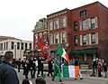
The 2011 Saint Patrick's Day parade in Hornell.

See also
 In Spanish: Hornell para niños
