Arkport, New York facts for kids
Quick facts for kids
Arkport, New York
|
|
|---|---|
|
Village
|
|

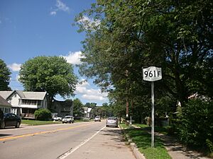
NY 961F in Arkport
|
|
| Country | United States |
| State | New York |
| County | Steuben |
| Area | |
| • Total | 0.69 sq mi (1.80 km2) |
| • Land | 0.69 sq mi (1.80 km2) |
| • Water | 0.00 sq mi (0.00 km2) |
| Elevation | 1,184 ft (361 m) |
| Population
(2020)
|
|
| • Total | 745 |
| • Density | 1,073.49/sq mi (414.31/km2) |
| Time zone | UTC-5 (Eastern (EST)) |
| • Summer (DST) | UTC-4 (EDT) |
| ZIP code |
14807
|
| Area code(s) | 607 |
| FIPS code | 36-02583 |
| GNIS feature ID | 0942554 |
Arkport is a small village in Steuben County, New York, United States. It is part of the town of Hornellsville. The village is located just north of the city of Hornell. In 2020, about 745 people lived there. The village got its name because people used special boats called "arks" to ship products from here a long time ago. The postal code for Arkport is 14807.
The Hornell Municipal Airport (HTF) is located right next to the village, to its south.
Contents
History
A Look Back at Arkport's Past
Arkport was founded in 1797 by a person named Christopher Hurlbut. In the early days, the Canisteo River was very important for shipping goods. Farmers and traders used large, flat-bottomed boats called "arks" to send crops, animals, and timber down the river to Baltimore.
The part of the river that boats could travel on ended right here in Arkport. This is why the village was named "Ark-port." Using arks to move goods continued until 1825. That's when the Erie Canal was built. Shipping goods by canal became much cheaper and easier. The Post Office building that is still there today was built in 1890.
Geography
Where is Arkport Located?
Arkport is located at coordinates 42 degrees, 23 minutes, 36 seconds North and 77 degrees, 41 minutes, 46 seconds West.
The United States Census Bureau says the village covers about 0.7 square miles (1.8 square kilometers) of land. There is no water area within the village limits.
The village sits on the eastern side of the Canisteo River.
Roads and Transportation
New York State Route 36 runs through the village from north to south. The Southern Tier Expressway is located between Arkport and Hornell. County Roads 48 and 67 also lead into the village.
Demographics
How Many People Live in Arkport?
| Historical population | |||
|---|---|---|---|
| Census | Pop. | %± | |
| 1840 | 175 | — | |
| 1860 | 250 | — | |
| 1920 | 463 | — | |
| 1930 | 575 | 24.2% | |
| 1940 | 618 | 7.5% | |
| 1950 | 701 | 13.4% | |
| 1960 | 837 | 19.4% | |
| 1970 | 984 | 17.6% | |
| 1980 | 811 | −17.6% | |
| 1990 | 770 | −5.1% | |
| 2000 | 832 | 8.1% | |
| 2010 | 844 | 1.4% | |
| 2020 | 745 | −11.7% | |
| U.S. Decennial Census | |||
In the year 2000, there were 832 people living in Arkport. These people lived in 348 households, and 231 of those were families. The village had about 1,210 people per square mile.
About 29% of the households had children under 18 living with them. More than half (51%) of the households were married couples living together. About 30% of households were single people living alone.
The average age of people in Arkport in 2000 was 42 years old. About 26% of the population was under 18. About 22% of the population was 65 years old or older.
See also
 In Spanish: Arkport para niños
 | Janet Taylor Pickett |
 | Synthia Saint James |
 | Howardena Pindell |
 | Faith Ringgold |


