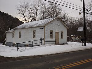
Hartsville, New York facts for kids
Quick facts for kids
Hartsville, New York
|
|
|---|---|

Town Hall
|
|
| Country | United States |
| State | New York |
| County | Steuben |
| Area | |
| • Total | 36.20 sq mi (93.75 km2) |
| • Land | 36.14 sq mi (93.61 km2) |
| • Water | 0.06 sq mi (0.15 km2) |
| Elevation | 2,116 ft (645 m) |
| Population
(2020)
|
|
| • Total | 561 |
| • Estimate
(2021)
|
554 |
| • Density | 16.43/sq mi (6.35/km2) |
| Time zone | UTC-5 (Eastern (EST)) |
| • Summer (DST) | UTC-4 (EDT) |
| FIPS code | 36-32567 |
| GNIS feature ID | 0979055 |
Hartsville is a small town located in Steuben County, New York, in the United States. In 2020, about 561 people lived there. The town was named after Reuben Hart, who was an important early settler in the area.
Hartsville is found on the western edge of Steuben County. It is located south of the city of Hornell.
Contents
History of Hartsville
The first people to settle permanently in Hartsville arrived around 1810.
At first, many people in the town worked in the lumber industry, cutting down trees. Over time, as more land was cleared, they started raising dairy cows instead.
The town of Hartsville was officially created in 1844. It was formed from a part of the Town of Hornellsville.
Geography of Hartsville
Hartsville covers a total area of about 36.2 square miles (93.75 square kilometers). Most of this area is land, with only a very small part being water.
The western border of Hartsville is also the border for Allegany County.
Nearby Towns and Areas
To the west of Hartsville is the Town of Alfred, which is in Allegany County. To the north, you'll find the Town of Hornellsville. The Town of Greenwood is located to the south. Hartsville also shares its eastern border with the Town of Canisteo.
Population Information
| Historical population | |||
|---|---|---|---|
| Census | Pop. | %± | |
| 1850 | 854 | — | |
| 1860 | 1,154 | 35.1% | |
| 1870 | 993 | −14.0% | |
| 1880 | 1,015 | 2.2% | |
| 1890 | 757 | −25.4% | |
| 1900 | 787 | 4.0% | |
| 1910 | 651 | −17.3% | |
| 1920 | 545 | −16.3% | |
| 1930 | 470 | −13.8% | |
| 1940 | 498 | 6.0% | |
| 1950 | 518 | 4.0% | |
| 1960 | 479 | −7.5% | |
| 1970 | 467 | −2.5% | |
| 1980 | 509 | 9.0% | |
| 1990 | 546 | 7.3% | |
| 2000 | 585 | 7.1% | |
| 2010 | 609 | 4.1% | |
| 2020 | 561 | −7.9% | |
| 2021 (est.) | 554 | −9.0% | |
| U.S. Decennial Census | |||
According to the 2020 census, there were 561 people living in Hartsville. The population density was about 16.43 people per square mile.
In 2000, there were 585 people in the town. About 28% of the households had children under 18 living there. Most households were married couples living together.
The median age in the town was 40 years old. This means half the people were younger than 40, and half were older.
Communities and Places in Hartsville
- Hartsville – This is the main hamlet (a small community) in the town. It is located near the center of the town on County Road 28. It was also known as "Hartsville Center" in the past.
- Purdy Creek – This is a stream that flows through the town and the hamlet of Hartsville. It was named after an early settler. Eventually, this creek flows into the Canisteo River.
- Webb Hollow – This is a valley located northwest of the Hartsville hamlet.
See also
 In Spanish: Hartsville (Nueva York) para niños
 | Janet Taylor Pickett |
 | Synthia Saint James |
 | Howardena Pindell |
 | Faith Ringgold |


