Erwin, New York facts for kids
Quick facts for kids
Erwin, New York
|
|
|---|---|

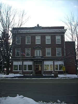
The Erwin town hall in Painted Post
|
|
| Country | United States |
| State | New York |
| County | Steuben |
| Area | |
| • Total | 39.16 sq mi (101.42 km2) |
| • Land | 38.66 sq mi (100.12 km2) |
| • Water | 0.50 sq mi (1.30 km2) |
| Elevation | 1,017 ft (310 m) |
| Population
(2020)
|
|
| • Total | 8,090 |
| • Estimate
(2021)
|
8,001 |
| • Density | 216.53/sq mi (83.60/km2) |
| Time zone | UTC-5 (Eastern (EST)) |
| • Summer (DST) | UTC-4 (EDT) |
| FIPS code | 36-24647 |
| GNIS feature ID | 0978943 |
Erwin is a town located in Steuben County, New York, United States. In 2020, about 8,090 people lived here. The town is named after an early settler who became its first leader. Erwin is in the southeastern part of Steuben County, just west of the city of Corning.
Contents
History of Erwin Town
The first permanent settlers arrived in the Erwin area around 1786. The name "Erwin" was first recorded in the United States census in 1790. The town of Erwin was officially formed in 1826. It was created from what was then called the "Town of Painted Post," which is now known as the town of Corning.
In 1837, part of Erwin was used to create the town of Lindley. However, Erwin later grew bigger in 1856 when it gained some land from the town of Corning.
The Mystery of the Painted Post
The "painted post" was a wooden post found in the southern part of Steuben County. People are still not sure why it was there or who put it there. It remains a local mystery.
Geography and Rivers
Erwin covers a total area of about 39.2 square miles (101.42 square kilometers). Most of this area, about 38.7 square miles (100.12 square kilometers), is land. The remaining 0.5 square miles (1.30 square kilometers) is water.
Several major roads pass through the town. These include Interstate 99/U.S. Route 15, New York State Route 414, New York State Route 417, and Interstate 86, also known as the Southern Tier Expressway.
Three important rivers meet near Erwin. The Tioga River joins the Cohocton River near Painted Post to form the Chemung River. The Chemung River then flows eastward. The Canisteo River also flows into the Tioga River close to the village of Erwins.
Population Changes Over Time
| Historical population | |||
|---|---|---|---|
| Census | Pop. | %± | |
| 1830 | 795 | — | |
| 1840 | 785 | −1.3% | |
| 1850 | 1,435 | 82.8% | |
| 1860 | 1,859 | 29.5% | |
| 1870 | 1,977 | 6.3% | |
| 1880 | 2,005 | 1.4% | |
| 1890 | 1,884 | −6.0% | |
| 1900 | 1,851 | −1.8% | |
| 1910 | 2,211 | 19.4% | |
| 1920 | 3,086 | 39.6% | |
| 1930 | 3,518 | 14.0% | |
| 1940 | 3,716 | 5.6% | |
| 1950 | 4,393 | 18.2% | |
| 1960 | 5,829 | 32.7% | |
| 1970 | 6,275 | 7.7% | |
| 1980 | 6,445 | 2.7% | |
| 1990 | 6,763 | 4.9% | |
| 2000 | 7,227 | 6.9% | |
| 2010 | 8,037 | 11.2% | |
| 2020 | 8,090 | 0.7% | |
| 2021 (est.) | 8,001 | −0.4% | |
| U.S. Decennial Census | |||
The population of Erwin has grown steadily over many years. In 1830, there were 795 people living in the town. By 2020, the population had increased to 8,090 people. This shows how the town has developed and become home to more families over time.
Places in the Town of Erwin
- Coopers Plains – This is a small community, called a hamlet, located in the northern part of the town.
- Corning-Painted Post Airport (7N1) – A small airport found west of Painted Post.
- Erwin Wildlife Management Area – This is a special area set aside to protect nature and wildlife. It's in the northwest part of the town.
- Erwins – Another hamlet located in the eastern part of the town, along New York State Route 417.
- Gang Mills – A hamlet southwest of the city of Corning, located on US Route 15.
- Painted Post – This is a village within the town of Erwin, located on New York State Route 415.
See also
 In Spanish: Erwin (Nueva York) para niños
 | Selma Burke |
 | Pauline Powell Burns |
 | Frederick J. Brown |
 | Robert Blackburn |


