Lindley, New York facts for kids
Quick facts for kids
Lindley, New York
|
|
|---|---|

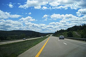
Southbound I-99 in Lindley
|
|
| Country | United States |
| State | New York |
| County | Steuben |
| Area | |
| • Total | 37.87 sq mi (98.08 km2) |
| • Land | 37.60 sq mi (97.38 km2) |
| • Water | 0.27 sq mi (0.70 km2) |
| Elevation | 1,224 ft (373 m) |
| Population
(2020)
|
|
| • Total | 1,816 |
| • Estimate
(2021)
|
1,794 |
| • Density | 51.55/sq mi (19.90/km2) |
| Time zone | UTC-5 (Eastern (EST)) |
| • Summer (DST) | UTC-4 (EDT) |
| ZIP code |
14858
|
| Area code(s) | 607 |
| FIPS code | 36-42576 |
| GNIS feature ID | 0979153 |
Lindley is a small town located in the southern part of Steuben County, New York. In 2020, about 1,816 people lived there. The town was named after an early settler, Eleazer Lindsley. You can find Lindley south of the city of Corning.
Contents
History of Lindley
The town of Lindley was officially created in 1837. It was formed from a part of the nearby town of Erwin.
Geography of Lindley
Lindley covers a total area of about 37.9 square miles (98.08 square kilometers). Most of this area, about 37.5 square miles (97.38 square kilometers), is land. The rest, about 0.3 square miles (0.70 square kilometers), is water.
The southern edge of the town is the border with Tioga County in Pennsylvania. Important roads like Interstate 99 and U.S. Route 15 run through the town from north to south. The Tioga River also flows through Lindley in the same direction.
Population and People
| Historical population | |||
|---|---|---|---|
| Census | Pop. | %± | |
| 1840 | 638 | — | |
| 1850 | 686 | 7.5% | |
| 1860 | 886 | 29.2% | |
| 1870 | 1,251 | 41.2% | |
| 1880 | 1,563 | 24.9% | |
| 1890 | 1,537 | −1.7% | |
| 1900 | 1,306 | −15.0% | |
| 1910 | 1,153 | −11.7% | |
| 1920 | 1,024 | −11.2% | |
| 1930 | 945 | −7.7% | |
| 1940 | 961 | 1.7% | |
| 1950 | 1,043 | 8.5% | |
| 1960 | 1,313 | 25.9% | |
| 1970 | 1,414 | 7.7% | |
| 1980 | 1,831 | 29.5% | |
| 1990 | 1,862 | 1.7% | |
| 2000 | 1,913 | 2.7% | |
| 2010 | 1,967 | 2.8% | |
| 2020 | 1,816 | −7.7% | |
| 2021 (est.) | 1,794 | −8.8% | |
| U.S. Decennial Census | |||
Based on the census from 2000, there were 1,913 people living in Lindley. These people lived in 697 households, and 545 of these were families. The population density was about 50.9 people per square mile (19.90 people per square kilometer).
About 35.9% of households had children under 18 living with them. Most households (63.3%) were married couples. About 17.2% of all households were single people living alone.
The people in Lindley were spread out by age. About 27.6% were under 18 years old. Around 9.6% were 65 years or older. The average age in the town was 35 years.
Communities in Lindley
The Town of Lindley includes a few smaller communities or hamlets:
- East Lindley – This hamlet is located near the eastern border of the town. It is found on County Road 120 and near Tannery Creek.
- Lawrenceville – This hamlet is on the southern border of the town. It is part of a larger community that continues into Pennsylvania.
- Lindley – This is the main hamlet of Lindley. It is near the center of the town, along US Route 15 and the Tioga River.
- Presho – This hamlet is in the northern part of the town. It is also on US Route 15, but on the west side of the Tioga River.
See also
 In Spanish: Lindley (Nueva York) para niños
 | Dorothy Vaughan |
 | Charles Henry Turner |
 | Hildrus Poindexter |
 | Henry Cecil McBay |


